Rainsville elevation
Rainsville (Alabama, DeKalb County), United States elevation is 395 meters and Rainsville elevation in feet is 1296 ft above sea level [src 1]. Rainsville is a populated place (feature code) with elevation that is 116 meters (381 ft) bigger than average city elevation in United States.
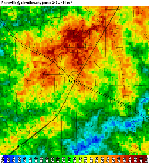
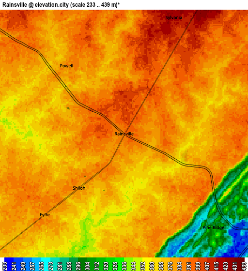
Below is the Elevation map of Rainsville, which displays elevation range with different colors. Scale of the first map is from 349 to 411 m (1145 to 1348 ft) with average elevation of 381.5 meters (=1252 ft) [note 1]
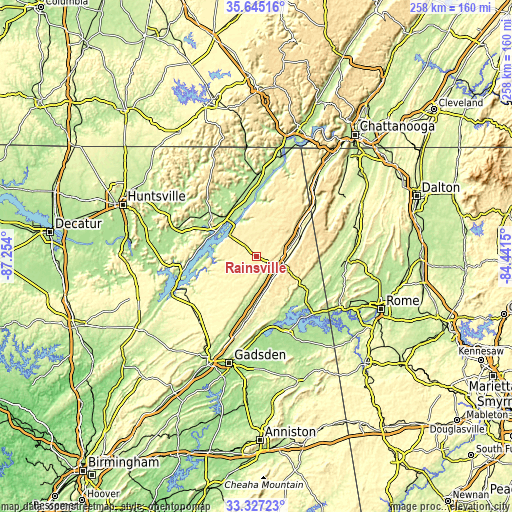
These maps also provides idea of topography and contour of this city, they are displayed at different zoom levels. More info about maps, scale and edge coordinates you can find below images.
| \ | Map #1 | Map #2 | Topo.Map |
| Scale [m] | 349..411 m | 233..439 m | × |
| Scale [ft] | 1145..1348 ft | 764..1440 ft | × |
| Average | 381.5 m = 1252 ft | 372.8 m = 1223 ft | × |
| Width | 8.05 km = 5 mi | 16.11 km = 10 mi | 257.7 km = 160.1 mi |
| Height | 8.05 km = 5 mi | 16.11 km = 10 mi | 257.7 km = 160.1 mi |
| ↑Max Latitude | 34.530461° | 34.566656° | 35.64516° |
| Latitude at center | 34.49425° | 34.49425° | 34.49425° |
| ↓Min Latitude | 34.458023° | 34.421781° | 33.32723° |
| ← Min Longitude | -85.891695° | -85.935641° | -87.254° |
| Longitude center | -85.84775° | -85.84775° | -85.84775° |
| →Max Longitude | -85.803805° | -85.759859° | -84.4415° |
Nearby cities:
Cities around Rainsville sort by population:
• Albertville elevation 323 m
41.6 km,  232°
232°
• Scottsboro 196 m
26.1 km,  319°
319°
• Fort Payne 278 m
13 km,  115°
115°
• Centre 201 m
41.1 km,  157°
157°
• Henagar 446 m
17.3 km,  25°
25°
• Stevenson 192 m
41.6 km,  1°
1°
• Collinsville 219 m
25.6 km,  182°
182°
• Sylvania 421 m
8.2 km,  23°
23°
• Crossville 346 m
26.6 km,  210°
210°
• Cedar Bluff 177 m
37.6 km,  144°
144°
• Fyffe 381 m
7.4 km,  224°
224°
• Leesburg 175 m
35.8 km,  167°
167°
Multilingual:
 En español:
Rainsville elevación 395 m.
 En France:
Rainsville élévation 395 m.
 Auf Deutsch:
Rainsville höhe über dem Meeresspiegel ist 395 m.

Sources and notes:
- [note 1] Map square and city borders are not equal. Map elevation data is calculated only from area inside that square.
- [src 1] Elevation data from geonames database provided with same terms of usage.
- [src 2] The elevation map of Rainsville is generated using elevation data from NASA's 3 arcsec (90m) resolution SRTM data.
- [src 3] Base (background) map © OpenStreetMap contributors tiles are generated by Geofabrik and OpenTopoMap.
Copyright & License:
This Rainsville Elevation Map is licensed under CC BY-SA. You may reuse any part from this page, if you give a proper credit by linking to this URL:
 More info on terms of use page.