Lake View elevation
Lake View (Alabama, Tuscaloosa County), United States elevation is 147 meters and Lake View elevation in feet is 482 ft above sea level [src 1]. Lake View is a populated place (feature code) with elevation that is 132 meters (433 ft) smaller than average city elevation in United States.
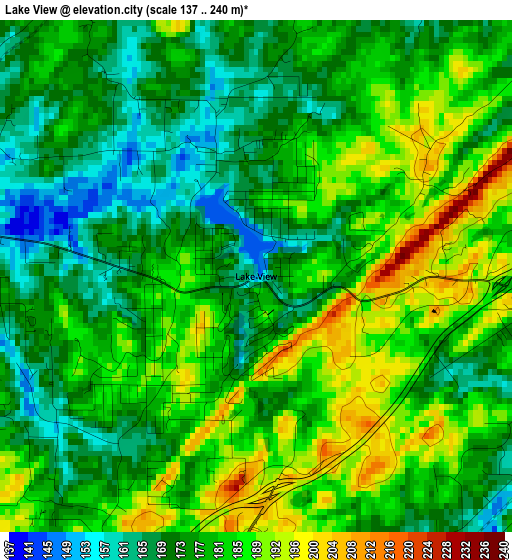
Below is the Elevation map of Lake View, which displays elevation range with different colors. Scale of the first map is from 137 to 240 m (449 to 787 ft) with average elevation of 178.4 meters (=585 ft) [note 1]
These maps also provides idea of topography and contour of this city, they are displayed at different zoom levels. More info about maps, scale and edge coordinates you can find below images.
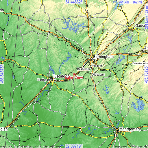
| \ | Map #1 | Topo.Map |
| Scale [m] | 137..240 m | × |
| Scale [ft] | 449..787 ft | × |
| Average | 178.4 m = 585 ft | × |
| Width | 8.17 km = 5.1 mi | 261.4 km = 162.4 mi |
| Height | 8.17 km = 5.1 mi | 261.4 km = 162.4 mi |
| ↑Max Latitude | 33.3174° | 34.44832° |
| Latitude at center | 33.28067° | 33.28067° |
| ↓Min Latitude | 33.243924° | 32.09719° |
| ← Min Longitude | -87.181445° | -88.54375° |
| Longitude center | -87.1375° | -87.1375° |
| →Max Longitude | -87.093555° | -85.73125° |
Nearby cities:
Cities around Lake View sort by population:
• Bessemer elevation 161 m
21.7 km,  51°
51°
• Hueytown 186 m
23 km,  34°
34°
• Brighton 161 m
24.6 km, 45°
• Lipscomb 168 m
25.4 km, 50°
• Concord 186 m
23 km, 25°
• Brookwood 184 m
17.3 km,  260°
260°
• Coaling 125 m
23.3 km,  234°
234°
• Woodstock 170 m
8.3 km,  188°
188°
• Vance 156 m
14.8 km,  217°
217°
• Rock Creek 187 m
22.5 km,  13°
13°
• West Blocton 156 m
18.1 km,  176°
176°
• North Bibb 176 m
8.6 km, 189°
Multilingual:
 En español:
Lake View elevación 147 m.
 En France:
Lake View élévation 147 m.
 Auf Deutsch:
Lake View höhe über dem Meeresspiegel ist 147 m.

Sources and notes:
- [note 1] Map square and city borders are not equal. Map elevation data is calculated only from area inside that square.
- [src 1] Elevation data from geonames database provided with same terms of usage.
- [src 2] The elevation map of Lake View is generated using elevation data from NASA's 3 arcsec (90m) resolution SRTM data.
- [src 3] Base (background) map © OpenStreetMap contributors tiles are generated by Geofabrik and OpenTopoMap.
Copyright & License:
This Lake View Elevation Map is licensed under CC BY-SA. You may reuse any part from this page, if you give a proper credit by linking to this URL:
 More info on terms of use page.