Dothan elevation
Dothan (Alabama, Houston County), United States elevation is 102 meters and Dothan elevation in feet is 335 ft above sea level [src 1]. Dothan is a seat of a second-order administrative division (feature code) with elevation that is 177 meters (581 ft) smaller than average city elevation in United States.
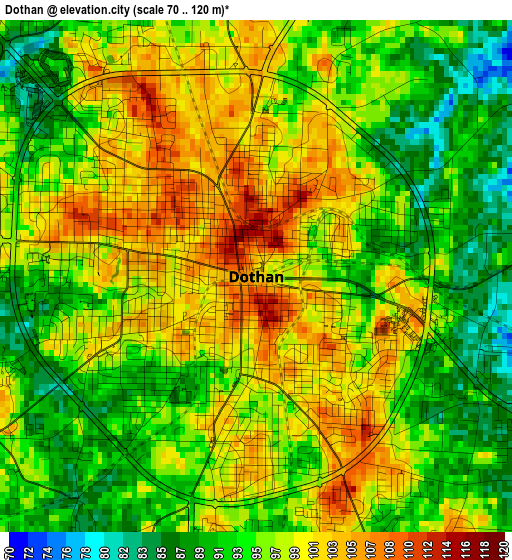
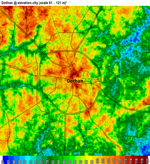
Below is the Elevation map of Dothan, which displays elevation range with different colors. Scale of the first map is from 70 to 120 m (230 to 394 ft) with average elevation of 96 meters (=315 ft) [note 1]
These maps also provides idea of topography and contour of this city, they are displayed at different zoom levels. More info about maps, scale and edge coordinates you can find below images.
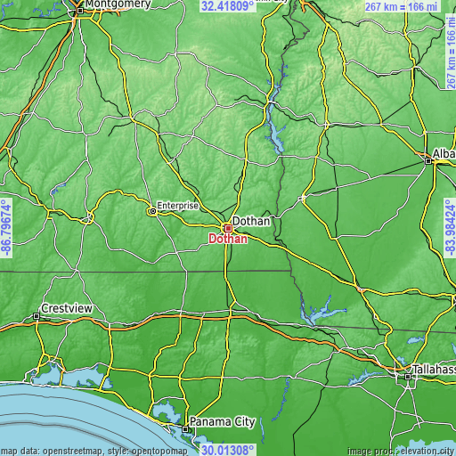
| \ | Map #1 | Map #2 | Topo.Map |
| Scale [m] | 70..120 m | 61..121 m | × |
| Scale [ft] | 230..394 ft | 200..397 ft | × |
| Average | 96 m = 315 ft | 91.6 m = 301 ft | × |
| Width | 8.36 km = 5.2 mi | 16.71 km = 10.4 mi | 267.4 km = 166.2 mi |
| Height | 8.36 km = 5.2 mi | 16.71 km = 10.4 mi | 267.4 km = 166.2 mi |
| ↑Max Latitude | 31.260803° | 31.29836° | 32.41809° |
| Latitude at center | 31.22323° | 31.22323° | 31.22323° |
| ↓Min Latitude | 31.185643° | 31.14804° | 30.01308° |
| ← Min Longitude | -85.434435° | -85.478381° | -86.79674° |
| Longitude center | -85.39049° | -85.39049° | -85.39049° |
| →Max Longitude | -85.346545° | -85.302599° | -83.98424° |
Nearby cities:
Cities around Dothan sort by population:
• Headland elevation 121 m
15 km,  17°
17°
• Taylor 103 m
9.8 km,  228°
228°
• Midland City 123 m
14.5 km,  317°
317°
• Kinsey 95 m
9.5 km,  27°
27°
• Ashford 79 m
15.3 km,  106°
106°
• Cowarts 104 m
8.6 km, 107°
• Slocomb 92 m
23.2 km,  236°
236°
• Newton 104 m
23.9 km,  301°
301°
• Rehobeth 80 m
12.6 km,  207°
207°
• Malvern 88 m
15.4 km, 232°
• Webb 88 m
11.9 km,  69°
69°
• Cottonwood 56 m
21 km,  157°
157°
Multilingual:
 En español:
Dothan elevación 102 m.
 En France:
Dothan élévation 102 m.


Sources and notes:
- [note 1] Map square and city borders are not equal. Map elevation data is calculated only from area inside that square.
- [src 1] Elevation data from geonames database provided with same terms of usage.
- [src 2] The elevation map of Dothan is generated using elevation data from NASA's 3 arcsec (90m) resolution SRTM data.
- [src 3] Base (background) map © OpenStreetMap contributors tiles are generated by Geofabrik and OpenTopoMap.
Copyright & License:
This Dothan Elevation Map is licensed under CC BY-SA. You may reuse any part from this page, if you give a proper credit by linking to this URL:
 More info on terms of use page.