Daphne elevation
Daphne (Alabama, Baldwin County), United States elevation is 56 meters and Daphne elevation in feet is 184 ft above sea level [src 1]. Daphne is a populated place (feature code) with elevation that is 223 meters (732 ft) smaller than average city elevation in United States.
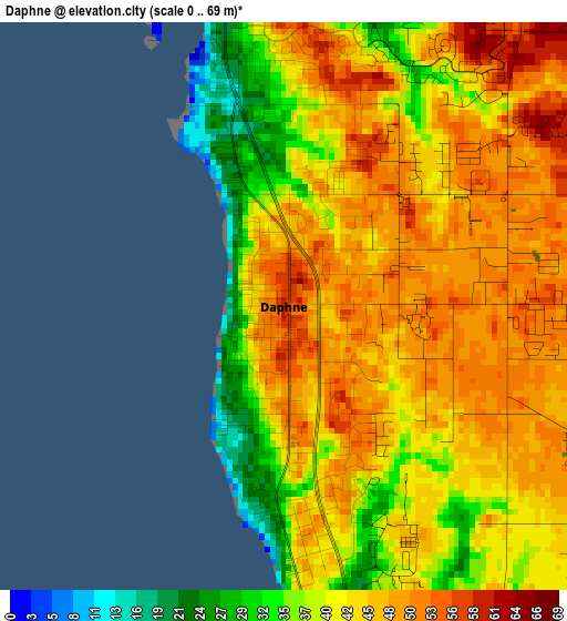
Below is the Elevation map of Daphne, which displays elevation range with different colors. Scale of the first map is from 0 to 69 m (0 to 226 ft) with average elevation of 43.5 meters (=143 ft) [note 1]
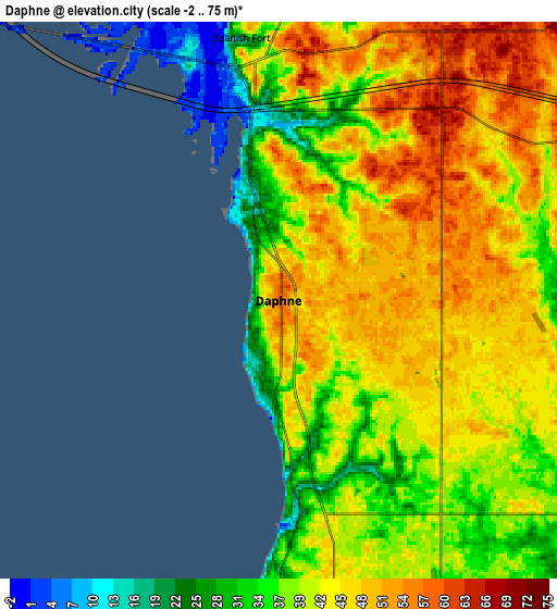
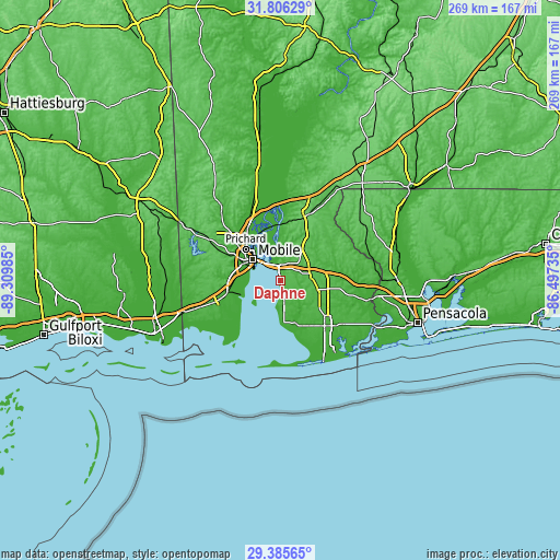
These maps also provides idea of topography and contour of this city, they are displayed at different zoom levels. More info about maps, scale and edge coordinates you can find below images.
| \ | Map #1 | Map #2 | Topo.Map |
| Scale [m] | 0..69 m | -2..75 m | × |
| Scale [ft] | 0..226 ft | -7..246 ft | × |
| Average | 43.5 m = 143 ft | 42.4 m = 139 ft | × |
| Width | 8.41 km = 5.2 mi | 16.82 km = 10.5 mi | 269.1 km = 167.2 mi |
| Height | 8.41 km = 5.2 mi | 16.82 km = 10.5 mi | 269.2 km = 167.3 mi |
| ↑Max Latitude | 30.641347° | 30.679149° | 31.80629° |
| Latitude at center | 30.60353° | 30.60353° | 30.60353° |
| ↓Min Latitude | 30.565698° | 30.527852° | 29.38565° |
| ← Min Longitude | -87.947545° | -87.991491° | -89.30985° |
| Longitude center | -87.9036° | -87.9036° | -87.9036° |
| →Max Longitude | -87.859655° | -87.815709° | -86.49735° |
Nearby cities:
Cities around Daphne sort by population:
• Mobile elevation 12 m
16.7 km,  307°
307°
• Prichard 14 m
22.5 km, 311°
• Fairhope 42 m
9 km,  179°
179°
• Tillmans Corner 28 m
25.6 km,  266°
266°
• Saraland 9 m
28.9 km,  326°
326°
• Spanish Fort 19 m
8 km,  351°
351°
• Theodore 22 m
26.7 km,  256°
256°
• Chickasaw 14 m
24.2 km,  317°
317°
• Robertsdale 49 m
19.2 km,  106°
106°
• Point Clear 10 m
14.5 km,  185°
185°
• Loxley 56 m
14.5 km,  83°
83°
• Summerdale 39 m
23.4 km,  123°
123°
Multilingual:
 En español:
Daphne elevación 56 m.
 En France:
Daphne élévation 56 m.


Sources and notes:
- [note 1] Map square and city borders are not equal. Map elevation data is calculated only from area inside that square.
- [src 1] Elevation data from geonames database provided with same terms of usage.
- [src 2] The elevation map of Daphne is generated using elevation data from NASA's 3 arcsec (90m) resolution SRTM data.
- [src 3] Base (background) map © OpenStreetMap contributors tiles are generated by Geofabrik and OpenTopoMap.
Copyright & License:
This Daphne Elevation Map is licensed under CC BY-SA. You may reuse any part from this page, if you give a proper credit by linking to this URL:
 More info on terms of use page.