Bytkiv elevation
Bytkiv (Ivano-Frankivsk), Ukraine elevation is 516 meters and Bytkiv elevation in feet is 1693 ft above sea level [src 1]. Bytkiv is a populated place (feature code) with elevation that is 359 meters (1178 ft) bigger than average city elevation in Ukraine.
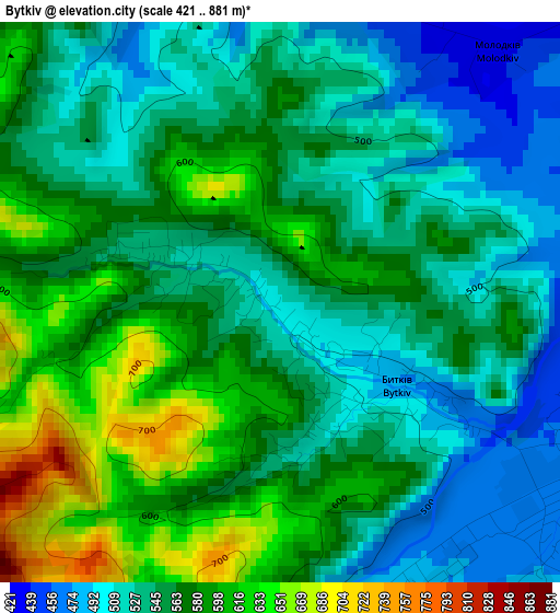
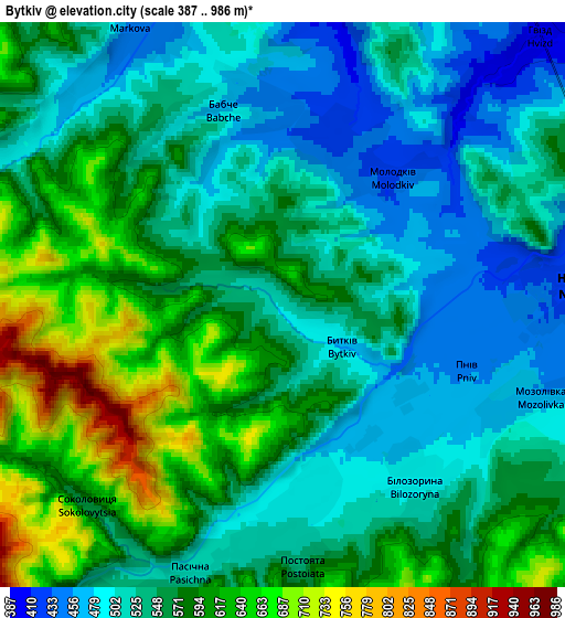
Below is the Elevation map of Bytkiv, which displays elevation range with different colors. Scale of the first map is from 421 to 881 m (1381 to 2890 ft) with average elevation of 556.8 meters (=1827 ft) [note 1]
These maps also provides idea of topography and contour of this city, they are displayed at different zoom levels. More info about maps, scale and edge coordinates you can find below images.
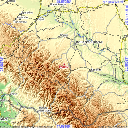
| \ | Map #1 | Map #2 | Topo.Map |
| Scale [m] | 421..881 m | 387..986 m | × |
| Scale [ft] | 1381..2890 ft | 1270..3235 ft | × |
| Average | 556.8 m = 1827 ft | 556.9 m = 1827 ft | × |
| Width | 6.46 km = 4 mi | 12.92 km = 8 mi | 206.7 km = 128.4 mi |
| Height | 6.46 km = 4 mi | 12.92 km = 8 mi | 206.7 km = 128.4 mi |
| ↑Max Latitude | 48.658716° | 48.687736° | 49.55056° |
| Latitude at center | 48.62968° | 48.62968° | 48.62968° |
| ↓Min Latitude | 48.600627° | 48.571558° | 47.69169° |
| ← Min Longitude | 24.430035° | 24.386089° | 23.06773° |
| Longitude center | 24.47398° | 24.47398° | 24.47398° |
| →Max Longitude | 24.517925° | 24.561871° | 25.88023° |
Nearby cities:
Cities around Bytkiv sort by population:
• Nadvirna elevation 428 m
7 km,  85°
85°
• Delyatyn 423 m
16.2 km,  136°
136°
• Kosmach 479 m
15.6 km,  329°
329°
• Pasichna 538 m
7.2 km,  206°
206°
• Pniv 451 m
4.2 km,  108°
108°
• Zarichchya 433 m
17.6 km,  133°
133°
• Solotvyn 428 m
8.9 km, 334°
• Manyava 534 m
7.8 km,  291°
291°
• Hvizd 399 m
8.3 km,  42°
42°
• Krasna 452 m
17.7 km, 109°
• Porohy 548 m
16.8 km, 292°
• Markova 461 m
6.8 km,  319°
319°
Multilingual:
 En español:
Bytkiv elevación 516 m.
 En France:
Bytkiv élévation 516 m.


Sources and notes:
- [note 1] Map square and city borders are not equal. Map elevation data is calculated only from area inside that square.
- [src 1] Elevation data from geonames database provided with same terms of usage.
- [src 2] The elevation map of Bytkiv is generated using elevation data from NASA's 3 arcsec (90m) resolution SRTM data.
- [src 3] Base (background) map © OpenStreetMap contributors tiles are generated by Geofabrik and OpenTopoMap.
Copyright & License:
This Bytkiv Elevation Map is licensed under CC BY-SA. You may reuse any part from this page, if you give a proper credit by linking to this URL:
 More info on terms of use page.