Zarichchya elevation
Zarichchya (Ivano-Frankivsk), Ukraine elevation is 433 meters and Zarichchya elevation in feet is 1421 ft above sea level [src 1]. Zarichchya is a populated place (feature code) with elevation that is 276 meters (906 ft) bigger than average city elevation in Ukraine.
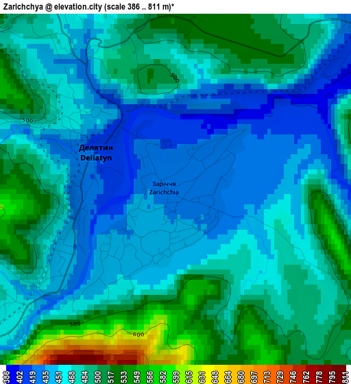
Below is the Elevation map of Zarichchya, which displays elevation range with different colors. Scale of the first map is from 386 to 811 m (1266 to 2661 ft) with average elevation of 476.4 meters (=1563 ft) [note 1]
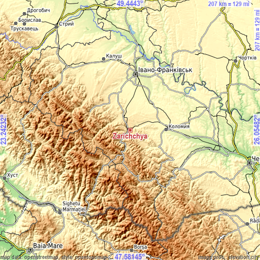
These maps also provides idea of topography and contour of this city, they are displayed at different zoom levels. More info about maps, scale and edge coordinates you can find below images.
| \ | Map #1 | Map #2 | Topo.Map |
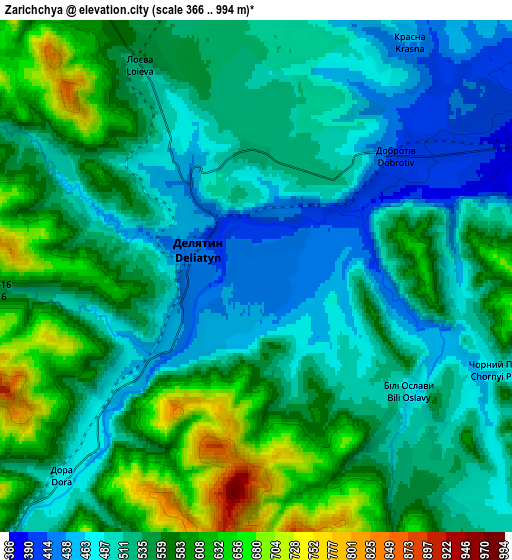
| Scale [m] | 386..811 m | 366..994 m | × |
| Scale [ft] | 1266..2661 ft | 1201..3261 ft | × |
| Average | 476.4 m = 1563 ft | 539.3 m = 1769 ft | × |
| Width | 6.47 km = 4 mi | 12.95 km = 8 mi | 207.1 km = 128.7 mi |
| Height | 6.47 km = 4 mi | 12.95 km = 8 mi | 207.1 km = 128.7 mi |
| ↑Max Latitude | 48.550538° | 48.57962° | 49.4443° |
| Latitude at center | 48.52144° | 48.52144° | 48.52144° |
| ↓Min Latitude | 48.492325° | 48.463193° | 47.58145° |
| ← Min Longitude | 24.604625° | 24.560679° | 23.24232° |
| Longitude center | 24.64857° | 24.64857° | 24.64857° |
| →Max Longitude | 24.692515° | 24.736461° | 26.05482° |
Nearby cities:
Cities around Zarichchya sort by population:
• Nadvirna elevation 428 m
13.9 km,  335°
335°
• Delyatyn 423 m
1.8 km,  277°
277°
• Lanchyn 379 m
8.9 km,  62°
62°
• Yaremche 521 m
10.4 km,  221°
221°
• Pechenizhyn 333 m
18.1 km,  92°
92°
• Pasichna 538 m
17 km,  289°
289°
• Pniv 451 m
13.9 km,  320°
320°
• Bili Oslavy 486 m
5.4 km,  134°
134°
• Bytkiv 516 m
17.6 km,  313°
313°
• Hvizd 399 m
19.6 km, 338°
• Sadzhavka 364 m
11.4 km, 64°
• Krasna 452 m
7.1 km,  32°
32°
Multilingual:
 En español:
Zarichchya elevación 433 m.
 En France:
Zarichchya élévation 433 m.
 Auf Deutsch:
Zarichchya höhe über dem Meeresspiegel ist 433 m.

Sources and notes:
- [note 1] Map square and city borders are not equal. Map elevation data is calculated only from area inside that square.
- [src 1] Elevation data from geonames database provided with same terms of usage.
- [src 2] The elevation map of Zarichchya is generated using elevation data from NASA's 3 arcsec (90m) resolution SRTM data.
- [src 3] Base (background) map © OpenStreetMap contributors tiles are generated by Geofabrik and OpenTopoMap.
Copyright & License:
This Zarichchya Elevation Map is licensed under CC BY-SA. You may reuse any part from this page, if you give a proper credit by linking to this URL:
 More info on terms of use page.