Chernivtsi elevation
Chernivtsi (Chernivtsi Oblast'), Ukraine elevation is 228 meters and Chernivtsi elevation in feet is 748 ft above sea level [src 1]. Chernivtsi is a seat of a first-order administrative division (feature code) with elevation that is 71 meters (233 ft) bigger than average city elevation in Ukraine.
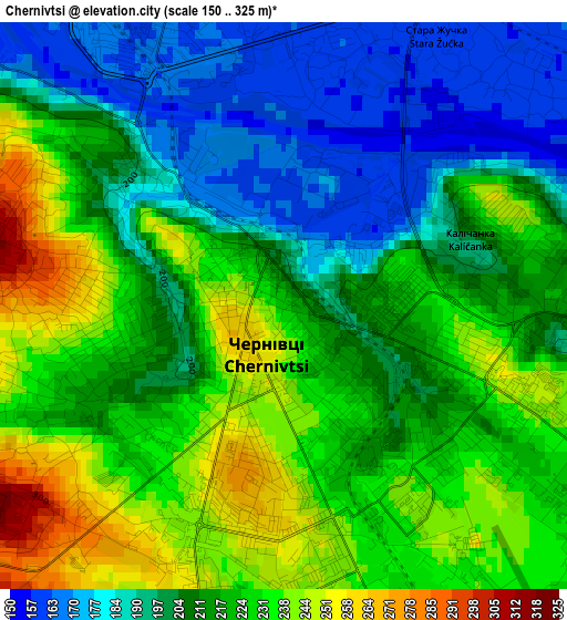
Below is the Elevation map of Chernivtsi, which displays elevation range with different colors. Scale of the first map is from 150 to 325 m (492 to 1066 ft) with average elevation of 214.1 meters (=702 ft) [note 1]
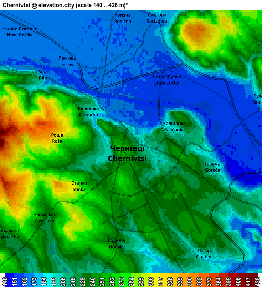
These maps also provides idea of topography and contour of this city, they are displayed at different zoom levels. More info about maps, scale and edge coordinates you can find below images.
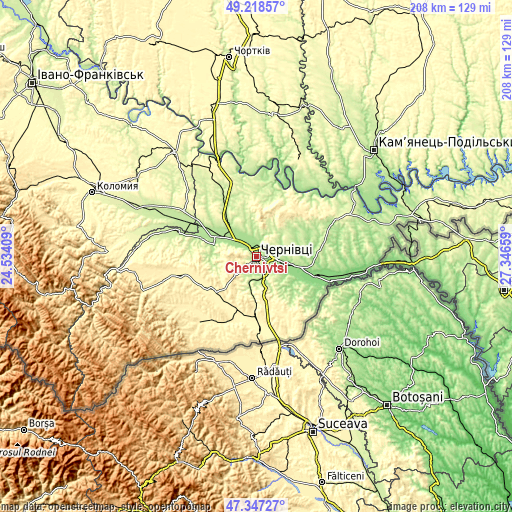
| \ | Map #1 | Map #2 | Topo.Map |
| Scale [m] | 150..325 m | 140..428 m | × |
| Scale [ft] | 492..1066 ft | 459..1404 ft | × |
| Average | 214.1 m = 702 ft | 220.7 m = 724 ft | × |
| Width | 6.5 km = 4 mi | 13 km = 8.1 mi | 208.1 km = 129.3 mi |
| Height | 6.5 km = 4 mi | 13 km = 8.1 mi | 208.1 km = 129.3 mi |
| ↑Max Latitude | 48.32072° | 48.349934° | 49.21857° |
| Latitude at center | 48.29149° | 48.29149° | 48.29149° |
| ↓Min Latitude | 48.262243° | 48.232979° | 47.34727° |
| ← Min Longitude | 25.896395° | 25.852449° | 24.53409° |
| Longitude center | 25.94034° | 25.94034° | 25.94034° |
| →Max Longitude | 25.984285° | 26.028231° | 27.34659° |
Nearby cities:
Cities around Chernivtsi sort by population:
• Hlyboka elevation 348 m
22.5 km,  182°
182°
• Zastavna 239 m
26.7 km,  344°
344°
• Novoselytsya 139 m
25.4 km,  108°
108°
• Marshintsy 134 m
27.3 km, 107°
• Luzhany 180 m
14.9 km,  303°
303°
• Boyany 163 m
13.9 km,  99°
99°
• Molodiya 240 m
9.7 km,  141°
141°
• Ropcha 344 m
22.7 km,  212°
212°
• Shypyntsi 182 m
17.2 km, 303°
• Voloka 246 m
11.1 km, 183°
• Storozhynets’ 368 m
21.6 km,  229°
229°
• Kitsman’ 217 m
21.2 km,  322°
322°
Multilingual:
 En español:
Chernivtsi elevación 228 m.
 En France:
Tchernivtsi élévation 228 m.
 Auf Deutsch:
Tschernowitz, Czernowitz höhe über dem Meeresspiegel ist 228 m.

Sources and notes:
- [note 1] Map square and city borders are not equal. Map elevation data is calculated only from area inside that square.
- [src 1] Elevation data from geonames database provided with same terms of usage.
- [src 2] The elevation map of Chernivtsi is generated using elevation data from NASA's 3 arcsec (90m) resolution SRTM data.
- [src 3] Base (background) map © OpenStreetMap contributors tiles are generated by Geofabrik and OpenTopoMap.
Copyright & License:
This Chernivtsi Elevation Map is licensed under CC BY-SA. You may reuse any part from this page, if you give a proper credit by linking to this URL:
 More info on terms of use page.