Dnipro elevation
Dnipro (Dnipropetrovsk, Dniprovs’ka Mis’ka Rada), Ukraine elevation is 100 meters and Dnipro elevation in feet is 328 ft above sea level [src 1]. Dnipro is a seat of a first-order administrative division (feature code) with elevation that is 57 meters (187 ft) smaller than average city elevation in Ukraine.
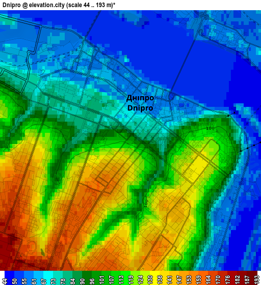
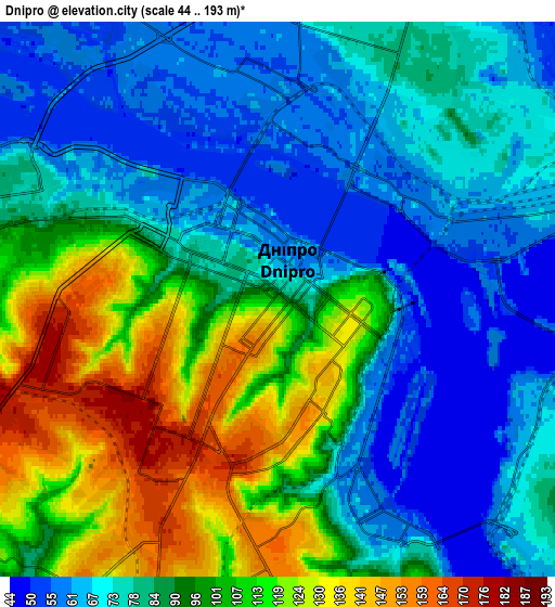
Below is the Elevation map of Dnipro, which displays elevation range with different colors. Scale of the first map is from 44 to 193 m (144 to 633 ft) with average elevation of 93.4 meters (=306 ft) [note 1]
These maps also provides idea of topography and contour of this city, they are displayed at different zoom levels. More info about maps, scale and edge coordinates you can find below images.
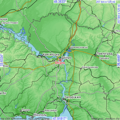
| \ | Map #1 | Map #2 | Topo.Map |
| Scale [m] | 44..193 m | 44..193 m | × |
| Scale [ft] | 144..633 ft | 144..633 ft | × |
| Average | 93.4 m = 306 ft | 89 m = 292 ft | × |
| Width | 6.48 km = 4 mi | 12.96 km = 8.1 mi | 207.4 km = 128.9 mi |
| Height | 6.48 km = 4 mi | 12.96 km = 8.1 mi | 207.4 km = 128.9 mi |
| ↑Max Latitude | 48.488434° | 48.517551° | 49.3833° |
| Latitude at center | 48.4593° | 48.4593° | 48.4593° |
| ↓Min Latitude | 48.430149° | 48.400982° | 47.51817° |
| ← Min Longitude | 34.994705° | 34.950759° | 33.6324° |
| Longitude center | 35.03865° | 35.03865° | 35.03865° |
| →Max Longitude | 35.082595° | 35.126541° | 36.4449° |
Nearby cities:
Cities around Dnipro sort by population:
• Kamianske elevation 94 m
32.7 km,  280°
280°
• Novomoskovs’k 58 m
25 km,  37°
37°
• Synel’nykove 171 m
38.6 km,  113°
113°
• Pidhorodne 56 m
13.8 km,  21°
21°
• Solone 105 m
30.5 km,  203°
203°
• Hubynykha 126 m
42.1 km, 22°
• Melioratyvne 72 m
33.6 km,  55°
55°
• Spas’ke 68 m
23.1 km,  2°
2°
• Partyzans’ke 61 m
22 km,  310°
310°
• Surs’ko-Mykhaylivka 65 m
31 km,  227°
227°
• Aviatorske 145 m
10.7 km,  162°
162°
• Kaydaki 134 m
11.1 km,  145°
145°
Multilingual:
 En español:
Dnipró elevación 100 m.
 En France:
Dnipro élévation 100 m.
 Auf Deutsch:
Dnipro höhe über dem Meeresspiegel ist 100 m.
 На русском:
Днепр, Екатеринослав, Днепропетровск, Jekatierinosław, Noworossijsk, Екатериносла́въ высота над уровнем моря 100 м
Sources and notes:
- [note 1] Map square and city borders are not equal. Map elevation data is calculated only from area inside that square.
- [src 1] Elevation data from geonames database provided with same terms of usage.
- [src 2] The elevation map of Dnipro is generated using elevation data from NASA's 3 arcsec (90m) resolution SRTM data.
- [src 3] Base (background) map © OpenStreetMap contributors tiles are generated by Geofabrik and OpenTopoMap.
Copyright & License:
This Dnipro Elevation Map is licensed under CC BY-SA. You may reuse any part from this page, if you give a proper credit by linking to this URL:
 More info on terms of use page.