Khodoriv elevation
Khodoriv (Lviv), Ukraine elevation is 265 meters and Khodoriv elevation in feet is 869 ft above sea level [src 1]. Khodoriv is a populated place (feature code) with elevation that is 108 meters (354 ft) bigger than average city elevation in Ukraine.
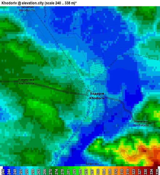
Below is the Elevation map of Khodoriv, which displays elevation range with different colors. Scale of the first map is from 240 to 338 m (787 to 1109 ft) with average elevation of 261.3 meters (=857 ft) [note 1]
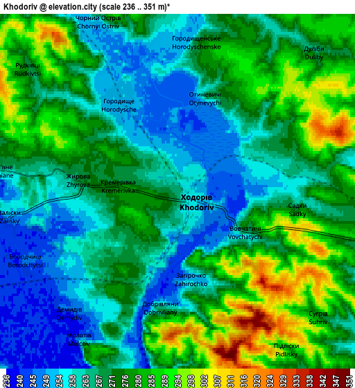
These maps also provides idea of topography and contour of this city, they are displayed at different zoom levels. More info about maps, scale and edge coordinates you can find below images.
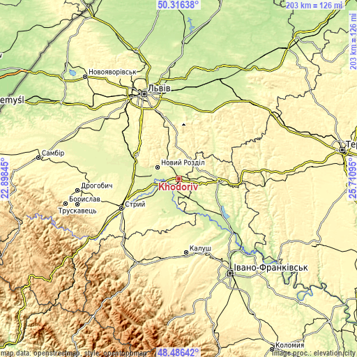
| \ | Map #1 | Map #2 | Topo.Map |
| Scale [m] | 240..338 m | 236..351 m | × |
| Scale [ft] | 787..1109 ft | 774..1152 ft | × |
| Average | 261.3 m = 857 ft | 270.7 m = 888 ft | × |
| Width | 6.36 km = 4 mi | 12.72 km = 7.9 mi | 203.5 km = 126.4 mi |
| Height | 6.36 km = 4 mi | 12.72 km = 7.9 mi | 203.5 km = 126.4 mi |
| ↑Max Latitude | 49.438514° | 49.467082° | 50.31638° |
| Latitude at center | 49.40993° | 49.40993° | 49.40993° |
| ↓Min Latitude | 49.381329° | 49.352711° | 48.48642° |
| ← Min Longitude | 24.260755° | 24.216809° | 22.89845° |
| Longitude center | 24.3047° | 24.3047° | 24.3047° |
| →Max Longitude | 24.348645° | 24.392591° | 25.71095° |
Nearby cities:
Cities around Khodoriv sort by population:
• Stryi elevation 296 m
36.4 km,  243°
243°
• Burshtyn 243 m
28.8 km,  125°
125°
• Mykolaiv 290 m
26.3 km,  298°
298°
• Rohatyn 255 m
22 km,  90°
90°
• Peremyshlyany 301 m
33.8 km,  32°
32°
• Bibrka 312 m
25.7 km,  357°
357°
• Rozvadiv 261 m
26.9 km,  292°
292°
• Rozdil 271 m
18.4 km, 288°
• Staroye Selo 302 m
34.4 km,  346°
346°
• Demnya 257 m
31.3 km, 304°
• Dzvinogrud 245 m
36.2 km, 353°
• Zhydachiv 261 m
12.1 km,  256°
256°
Multilingual:
 En español:
Jódoriv elevación 265 m.
 En France:
Khodoriv élévation 265 m.
 Auf Deutsch:
Chodoriw höhe über dem Meeresspiegel ist 265 m.

Sources and notes:
- [note 1] Map square and city borders are not equal. Map elevation data is calculated only from area inside that square.
- [src 1] Elevation data from geonames database provided with same terms of usage.
- [src 2] The elevation map of Khodoriv is generated using elevation data from NASA's 3 arcsec (90m) resolution SRTM data.
- [src 3] Base (background) map © OpenStreetMap contributors tiles are generated by Geofabrik and OpenTopoMap.
Copyright & License:
This Khodoriv Elevation Map is licensed under CC BY-SA. You may reuse any part from this page, if you give a proper credit by linking to this URL:
 More info on terms of use page.