Stryi elevation
Stryi (Lviv), Ukraine elevation is 296 meters and Stryi elevation in feet is 971 ft above sea level [src 1]. Stryi is a populated place (feature code) with elevation that is 139 meters (456 ft) bigger than average city elevation in Ukraine.
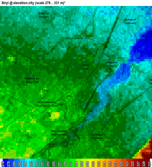
Below is the Elevation map of Stryi, which displays elevation range with different colors. Scale of the first map is from 276 to 331 m (906 to 1086 ft) with average elevation of 293.3 meters (=962 ft) [note 1]
These maps also provides idea of topography and contour of this city, they are displayed at different zoom levels. More info about maps, scale and edge coordinates you can find below images.
| \ | Map #1 | Map #2 | Topo.Map |
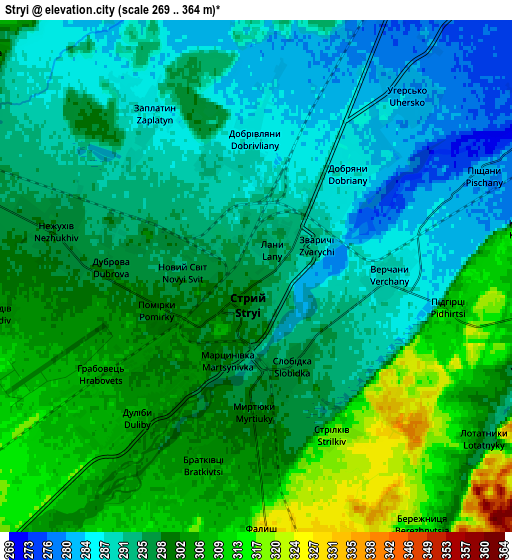
| Scale [m] | 276..331 m | 269..364 m | × |
| Scale [ft] | 906..1086 ft | 883..1194 ft | × |
| Average | 293.3 m = 962 ft | 297.1 m = 975 ft | × |
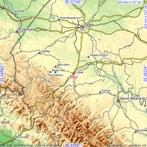
| Width | 6.38 km = 4 mi | 12.76 km = 7.9 mi | 204.1 km = 126.8 mi |
| Height | 6.38 km = 4 mi | 12.76 km = 7.9 mi | 204.1 km = 126.8 mi |
| ↑Max Latitude | 49.2909° | 49.319554° | 50.17143° |
| Latitude at center | 49.26223° | 49.26223° | 49.26223° |
| ↓Min Latitude | 49.233543° | 49.204839° | 48.33597° |
| ← Min Longitude | 23.812145° | 23.768199° | 22.44984° |
| Longitude center | 23.85609° | 23.85609° | 23.85609° |
| →Max Longitude | 23.900035° | 23.943981° | 25.26234° |
Nearby cities:
Cities around Stryi sort by population:
• Drohobych elevation 301 m
27.2 km,  290°
290°
• Truskavets’ 356 m
25.4 km,  274°
274°
• Stebnyk 314 m
21.5 km,  279°
279°
• Bolekhiv 365 m
21.8 km,  178°
178°
• Morshyn 337 m
11.8 km,  174°
174°
• Ulychne 339 m
15.2 km,  258°
258°
• Verkhnie Synevydne 379 m
26.2 km,  227°
227°
• Duliby 306 m
4.5 km,  220°
220°
• Medenychi 268 m
20.2 km,  337°
337°
• Rykhtychi 293 m
25.6 km,  302°
302°
• Rozdil 271 m
26.7 km,  33°
33°
• Zhydachiv 261 m
24.8 km,  56°
56°
Multilingual:
 En español:
Stryi elevación 296 m.
 En France:
Stryi élévation 296 m.


Sources and notes:
- [note 1] Map square and city borders are not equal. Map elevation data is calculated only from area inside that square.
- [src 1] Elevation data from geonames database provided with same terms of usage.
- [src 2] The elevation map of Stryi is generated using elevation data from NASA's 3 arcsec (90m) resolution SRTM data.
- [src 3] Base (background) map © OpenStreetMap contributors tiles are generated by Geofabrik and OpenTopoMap.
Copyright & License:
This Stryi Elevation Map is licensed under CC BY-SA. You may reuse any part from this page, if you give a proper credit by linking to this URL:
 More info on terms of use page.