Kremenchuk elevation
Kremenchuk (Poltava, Kremenchugskiy Rayon), Ukraine elevation is 66 meters and Kremenchuk elevation in feet is 217 ft above sea level [src 1]. Kremenchuk is a seat of a second-order administrative division (feature code) with elevation that is 91 meters (299 ft) smaller than average city elevation in Ukraine.
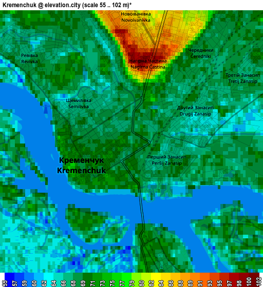
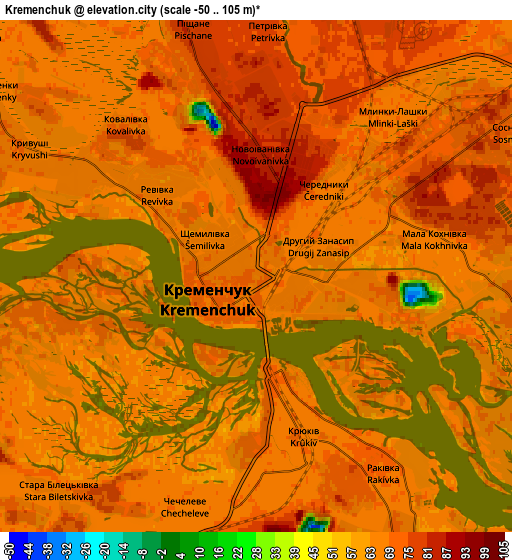
Below is the Elevation map of Kremenchuk, which displays elevation range with different colors. Scale of the first map is from 55 to 102 m (180 to 335 ft) with average elevation of 68.2 meters (=224 ft) [note 1]
These maps also provides idea of topography and contour of this city, they are displayed at different zoom levels. More info about maps, scale and edge coordinates you can find below images.
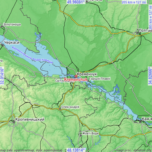
| \ | Map #1 | Map #2 | Topo.Map |
| Scale [m] | 55..102 m | -50..105 m | × |
| Scale [ft] | 180..335 ft | -164..344 ft | × |
| Average | 68.2 m = 224 ft | 68.5 m = 225 ft | × |
| Width | 6.4 km = 4 mi | 12.81 km = 8 mi | 204.9 km = 127.3 mi |
| Height | 6.4 km = 4 mi | 12.81 km = 8 mi | 204.9 km = 127.3 mi |
| ↑Max Latitude | 49.096803° | 49.125569° | 49.98081° |
| Latitude at center | 49.06802° | 49.06802° | 49.06802° |
| ↓Min Latitude | 49.03922° | 49.010404° | 48.13814° |
| ← Min Longitude | 33.376465° | 33.332519° | 32.01416° |
| Longitude center | 33.42041° | 33.42041° | 33.42041° |
| →Max Longitude | 33.464355° | 33.508301° | 34.82666° |
Nearby cities:
Cities around Kremenchuk sort by population:
• Oleksandriya elevation 106 m
49.6 km,  206°
206°
• Horishni Plavni 69 m
17 km,  112°
112°
• Svitlovods’k 68 m
13.2 km,  260°
260°
• Hlobyne 95 m
37.4 km,  341°
341°
• Chyhyryn 76 m
55.7 km,  271°
271°
• Hradyz’k 89 m
27.8 km,  311°
311°
• Pavlysh 106 m
17.4 km,  195°
195°
• Onufriyivka 101 m
18 km,  173°
173°
• Kamennyye Potoki 66 m
12.5 km,  141°
141°
• Pryyutivka 107 m
46.3 km, 213°
• Lutovynivka 82 m
40 km,  61°
61°
• Kozel’shchyna 86 m
35.2 km, 61°
Multilingual:
 En español:
Kremenchuk elevación 66 m.
 En France:
Krementchouk élévation 66 m.
 Auf Deutsch:
Krementschuk höhe über dem Meeresspiegel ist 66 m.

Sources and notes:
- [note 1] Map square and city borders are not equal. Map elevation data is calculated only from area inside that square.
- [src 1] Elevation data from geonames database provided with same terms of usage.
- [src 2] The elevation map of Kremenchuk is generated using elevation data from NASA's 3 arcsec (90m) resolution SRTM data.
- [src 3] Base (background) map © OpenStreetMap contributors tiles are generated by Geofabrik and OpenTopoMap.
Copyright & License:
This Kremenchuk Elevation Map is licensed under CC BY-SA. You may reuse any part from this page, if you give a proper credit by linking to this URL:
 More info on terms of use page.