Pavlysh elevation
Pavlysh (Kirovohrad), Ukraine elevation is 106 meters and Pavlysh elevation in feet is 348 ft above sea level [src 1]. Pavlysh is a populated place (feature code) with elevation that is 51 meters (167 ft) smaller than average city elevation in Ukraine.
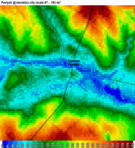
Below is the Elevation map of Pavlysh, which displays elevation range with different colors. Scale of the first map is from 87 to 183 m (285 to 600 ft) with average elevation of 126.1 meters (=414 ft) [note 1]
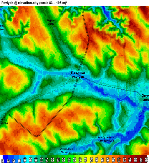
These maps also provides idea of topography and contour of this city, they are displayed at different zoom levels. More info about maps, scale and edge coordinates you can find below images.
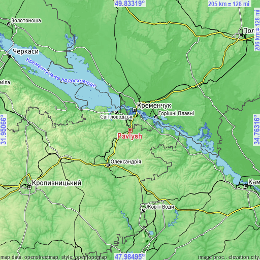
| \ | Map #1 | Map #2 | Topo.Map |
| Scale [m] | 87..183 m | 83..195 m | × |
| Scale [ft] | 285..600 ft | 272..640 ft | × |
| Average | 126.1 m = 414 ft | 133.6 m = 438 ft | × |
| Width | 6.42 km = 4 mi | 12.84 km = 8 mi | 205.5 km = 127.7 mi |
| Height | 6.42 km = 4 mi | 12.84 km = 8 mi | 205.5 km = 127.7 mi |
| ↑Max Latitude | 48.94649° | 48.975343° | 49.83319° |
| Latitude at center | 48.91762° | 48.91762° | 48.91762° |
| ↓Min Latitude | 48.888733° | 48.85983° | 47.98495° |
| ← Min Longitude | 33.312965° | 33.269019° | 31.95066° |
| Longitude center | 33.35691° | 33.35691° | 33.35691° |
| →Max Longitude | 33.400855° | 33.444801° | 34.76316° |
Nearby cities:
Cities around Pavlysh sort by population:
• Kremenchuk elevation 66 m
17.4 km,  15°
15°
• Oleksandriya 106 m
32.7 km,  212°
212°
• Horishni Plavni 69 m
22.8 km,  63°
63°
• Svitlovods’k 68 m
16.9 km,  329°
329°
• Hradyz’k 89 m
38.7 km,  335°
335°
• Oleksandriys’ke 145 m
44 km,  218°
218°
• Novyy Starodub 87 m
46.7 km,  196°
196°
• Onufriyivka 101 m
6.8 km,  99°
99°
• Kamennyye Potoki 66 m
14.2 km, 60°
• Pryyutivka 107 m
30.3 km, 223°
• Pantayivka 182 m
44 km,  231°
231°
• Lykhivka 72 m
48.7 km,  121°
121°
Multilingual:
 En español:
Pavlysh elevación 106 m.
 En France:
Pavlysh élévation 106 m.


Sources and notes:
- [note 1] Map square and city borders are not equal. Map elevation data is calculated only from area inside that square.
- [src 1] Elevation data from geonames database provided with same terms of usage.
- [src 2] The elevation map of Pavlysh is generated using elevation data from NASA's 3 arcsec (90m) resolution SRTM data.
- [src 3] Base (background) map © OpenStreetMap contributors tiles are generated by Geofabrik and OpenTopoMap.
Copyright & License:
This Pavlysh Elevation Map is licensed under CC BY-SA. You may reuse any part from this page, if you give a proper credit by linking to this URL:
 More info on terms of use page.