Poltavka elevation
Poltavka (Republic of Crimea, Krasnohvardiiske Raion), Ukraine elevation is 68 meters and Poltavka elevation in feet is 223 ft above sea level [src 1]. Poltavka is a seat of a third-order administrative division (feature code) with elevation that is 89 meters (292 ft) smaller than average city elevation in Ukraine.
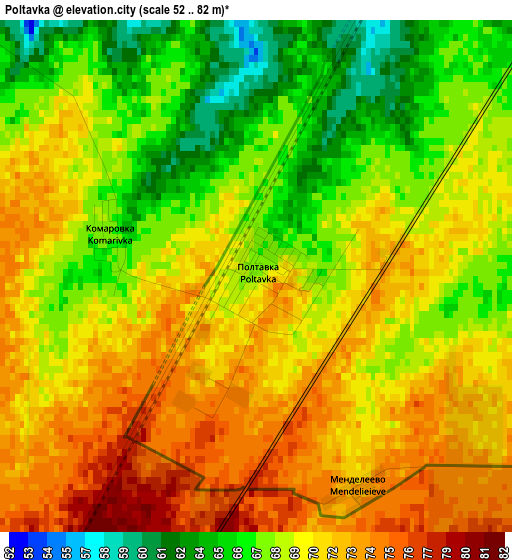
Below is the Elevation map of Poltavka, which displays elevation range with different colors. Scale of the first map is from 52 to 82 m (171 to 269 ft) with average elevation of 69.6 meters (=228 ft) [note 1]
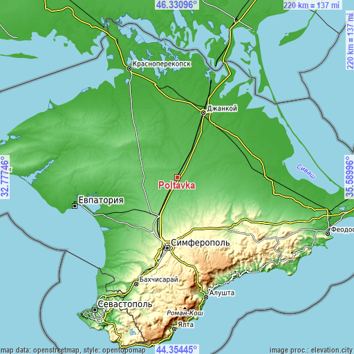
These maps also provides idea of topography and contour of this city, they are displayed at different zoom levels. More info about maps, scale and edge coordinates you can find below images.
| \ | Map #1 | Topo.Map |
| Scale [m] | 52..82 m | × |
| Scale [ft] | 171..269 ft | × |
| Average | 69.6 m = 228 ft | × |
| Width | 6.87 km = 4.3 mi | 219.8 km = 136.6 mi |
| Height | 6.87 km = 4.3 mi | 219.8 km = 136.6 mi |
| ↑Max Latitude | 45.382204° | 46.33096° |
| Latitude at center | 45.35133° | 45.35133° |
| ↓Min Latitude | 45.320439° | 44.35445° |
| ← Min Longitude | 34.139765° | 32.77746° |
| Longitude center | 34.18371° | 34.18371° |
| →Max Longitude | 34.227655° | 35.58996° |
Nearby cities:
Cities around Poltavka sort by population:
• Oktyabr’skoye elevation 90 m
7.9 km,  208°
208°
• Petrovka 42 m
18.2 km,  26°
26°
• Amurskoye 92 m
9.2 km, 208°
• Mar’yanovka 52 m
13.7 km,  39°
39°
• Pyatikhatka 61 m
6.4 km,  119°
119°
• Yantarnoye 53 m
9.7 km,  17°
17°
• Leninskoye 87 m
13.9 km,  228°
228°
• Rovnoye 55 m
13.2 km,  89°
89°
• Kotel’nikovo 68 m
12.4 km,  277°
277°
• Krasnoznamenka 85 m
16 km,  243°
243°
• Novoestoniya 51 m
17.1 km, 15°
• Nekrasovo 49 m
11.4 km, 44°
Multilingual:
 En español:
Poltavka elevación 68 m.
 En France:
Poltavka élévation 68 m.


Sources and notes:
- [note 1] Map square and city borders are not equal. Map elevation data is calculated only from area inside that square.
- [src 1] Elevation data from geonames database provided with same terms of usage.
- [src 2] The elevation map of Poltavka is generated using elevation data from NASA's 3 arcsec (90m) resolution SRTM data.
- [src 3] Base (background) map © OpenStreetMap contributors tiles are generated by Geofabrik and OpenTopoMap.
Copyright & License:
This Poltavka Elevation Map is licensed under CC BY-SA. You may reuse any part from this page, if you give a proper credit by linking to this URL:
 More info on terms of use page.