Nekrasovo elevation
Nekrasovo (Republic of Crimea, Krasnohvardiiske Raion), Ukraine elevation is 49 meters and Nekrasovo elevation in feet is 161 ft above sea level [src 1]. Nekrasovo is a populated place (feature code) with elevation that is 108 meters (354 ft) smaller than average city elevation in Ukraine.
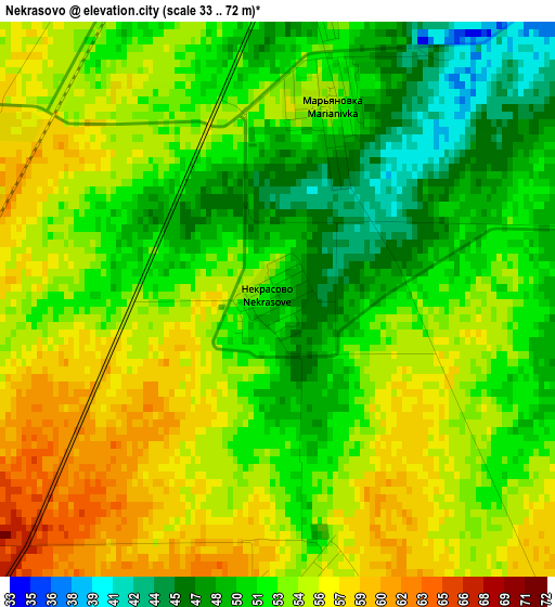
Below is the Elevation map of Nekrasovo, which displays elevation range with different colors. Scale of the first map is from 33 to 72 m (108 to 236 ft) with average elevation of 52.5 meters (=172 ft) [note 1]
These maps also provides idea of topography and contour of this city, they are displayed at different zoom levels. More info about maps, scale and edge coordinates you can find below images.
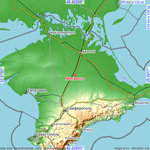
| \ | Map #1 | Topo.Map |
| Scale [m] | 33..72 m | × |
| Scale [ft] | 108..236 ft | × |
| Average | 52.5 m = 172 ft | × |
| Width | 6.86 km = 4.3 mi | 219.5 km = 136.4 mi |
| Height | 6.86 km = 4.3 mi | 219.5 km = 136.4 mi |
| ↑Max Latitude | 45.455365° | 46.40288° |
| Latitude at center | 45.42453° | 45.42453° |
| ↓Min Latitude | 45.393679° | 44.42893° |
| ← Min Longitude | 34.241505° | 32.8792° |
| Longitude center | 34.28545° | 34.28545° |
| →Max Longitude | 34.329395° | 35.6917° |
Nearby cities:
Cities around Nekrasovo sort by population:
• Krasnogvardeyskoye elevation 36 m
8.8 km,  8°
8°
• Petrovka 42 m
8.1 km,  1°
1°
• Voskhod 40 m
12.7 km,  41°
41°
• Mar’yanovka 52 m
2.5 km,  16°
16°
• Pyatikhatka 61 m
11.5 km,  191°
191°
• Yantarnoye 53 m
5.1 km,  282°
282°
• Vol’noye 41 m
15.8 km, 5°
• Klepinino 37 m
14 km,  325°
325°
• Poltavka 68 m
11.4 km,  224°
224°
• Rovnoye 55 m
9.7 km,  147°
147°
• Novopokrovka 40 m
12.9 km,  91°
91°
• Novoestoniya 51 m
9 km,  338°
338°
Multilingual:
 En español:
Nekrasovo elevación 49 m.
 En France:
Nekrasovo élévation 49 m.
 Auf Deutsch:
Nekrasovo höhe über dem Meeresspiegel ist 49 m.

Sources and notes:
- [note 1] Map square and city borders are not equal. Map elevation data is calculated only from area inside that square.
- [src 1] Elevation data from geonames database provided with same terms of usage.
- [src 2] The elevation map of Nekrasovo is generated using elevation data from NASA's 3 arcsec (90m) resolution SRTM data.
- [src 3] Base (background) map © OpenStreetMap contributors tiles are generated by Geofabrik and OpenTopoMap.
Copyright & License:
This Nekrasovo Elevation Map is licensed under CC BY-SA. You may reuse any part from this page, if you give a proper credit by linking to this URL:
 More info on terms of use page.