Olevs’k elevation
Olevs’k (Zhytomyr), Ukraine elevation is 180 meters and Olevs’k elevation in feet is 591 ft above sea level [src 1]. Olevs’k is a seat of a second-order administrative division (feature code) with elevation that is 23 meters (75 ft) bigger than average city elevation in Ukraine.
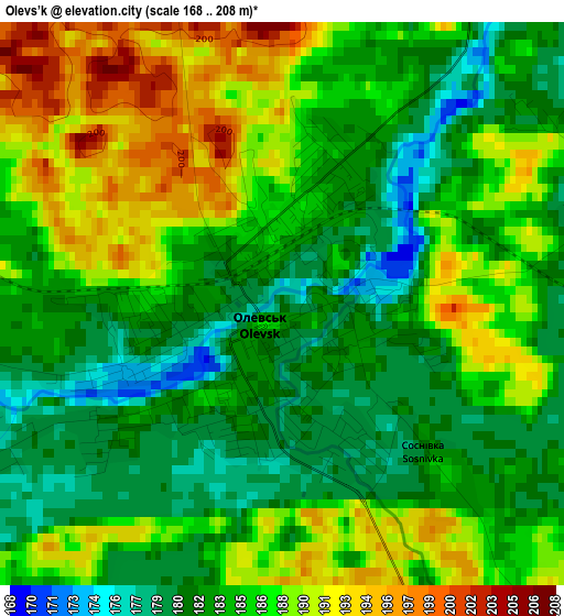
Below is the Elevation map of Olevs’k, which displays elevation range with different colors. Scale of the first map is from 168 to 208 m (551 to 682 ft) with average elevation of 185.3 meters (=608 ft) [note 1]
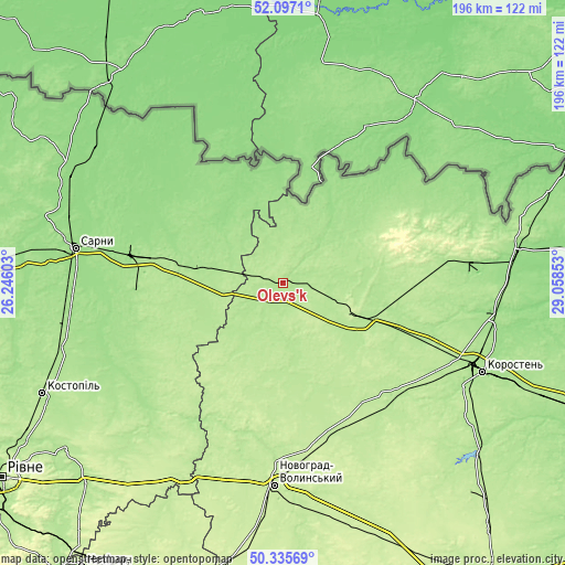
These maps also provides idea of topography and contour of this city, they are displayed at different zoom levels. More info about maps, scale and edge coordinates you can find below images.
| \ | Map #1 | Topo.Map |
| Scale [m] | 168..208 m | × |
| Scale [ft] | 551..682 ft | × |
| Average | 185.3 m = 608 ft | × |
| Width | 6.12 km = 3.8 mi | 195.9 km = 121.7 mi |
| Height | 6.12 km = 3.8 mi | 195.8 km = 121.7 mi |
| ↑Max Latitude | 51.252333° | 52.0971° |
| Latitude at center | 51.22482° | 51.22482° |
| ↓Min Latitude | 51.19729° | 50.33569° |
| ← Min Longitude | 27.608335° | 26.24603° |
| Longitude center | 27.65228° | 27.65228° |
| →Max Longitude | 27.696225° | 29.05853° |
Nearby cities:
Cities around Olevs’k sort by population:
• Korosten’ elevation 178 m
74.9 km,  113°
113°
• Novohrad-Volynskyi 218 m
70.2 km,  182°
182°
• Sarny 158 m
74.1 km,  279°
279°
• Ovruch 165 m
80.8 km,  82°
82°
• Rokytne 174 m
31.1 km, 281°
• Korets 214 m
75.9 km,  207°
207°
• Horodnytsya 196 m
52.1 km, 206°
• Luhyny 176 m
54.5 km, 106°
• Koloniya Zastav’ye 197 m
62.7 km,  223°
223°
• Novi Bilokorovychi 189 m
30.6 km, 113°
• Berezne 165 m
67.7 km,  248°
248°
• Yemil’chyne 201 m
40.5 km,  164°
164°
Multilingual:
 En español:
Olevs’k elevación 180 m.
 En France:
Olevs’k élévation 180 m.


Sources and notes:
- [note 1] Map square and city borders are not equal. Map elevation data is calculated only from area inside that square.
- [src 1] Elevation data from geonames database provided with same terms of usage.
- [src 2] The elevation map of Olevs’k is generated using elevation data from NASA's 3 arcsec (90m) resolution SRTM data.
- [src 3] Base (background) map © OpenStreetMap contributors tiles are generated by Geofabrik and OpenTopoMap.
Copyright & License:
This Olevs’k Elevation Map is licensed under CC BY-SA. You may reuse any part from this page, if you give a proper credit by linking to this URL:
 More info on terms of use page.