Korosten’ elevation
Korosten’ (Zhytomyr), Ukraine elevation is 178 meters and Korosten’ elevation in feet is 584 ft above sea level [src 1]. Korosten’ is a seat of a second-order administrative division (feature code) with elevation that is 21 meters (69 ft) bigger than average city elevation in Ukraine.
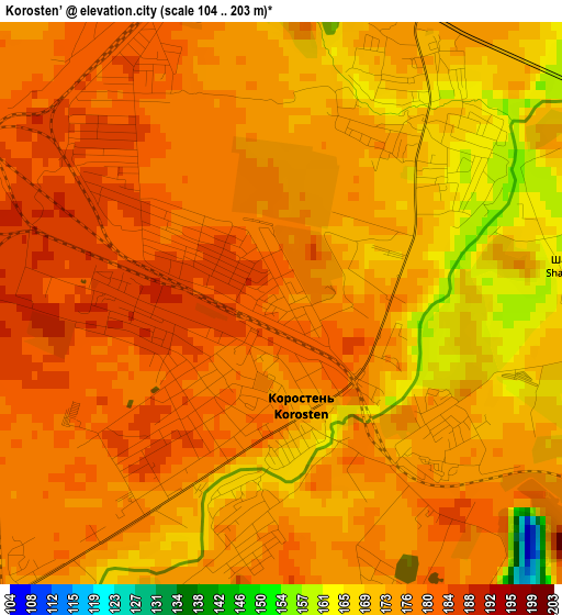
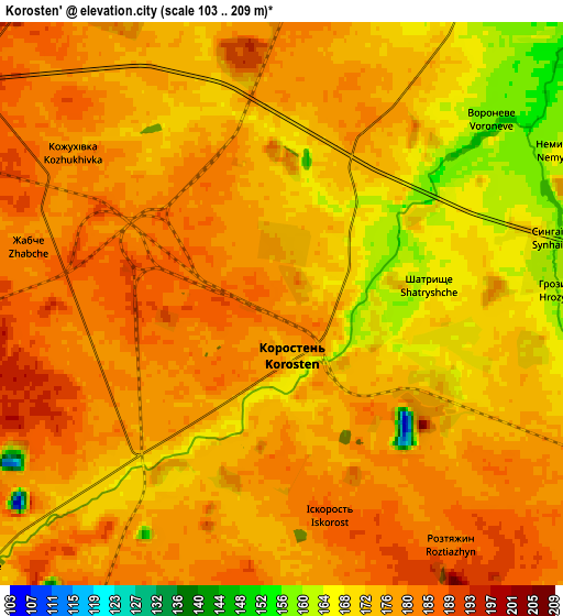
Below is the Elevation map of Korosten’, which displays elevation range with different colors. Scale of the first map is from 104 to 203 m (341 to 666 ft) with average elevation of 175.6 meters (=576 ft) [note 1]
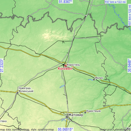
These maps also provides idea of topography and contour of this city, they are displayed at different zoom levels. More info about maps, scale and edge coordinates you can find below images.
| \ | Map #1 | Map #2 | Topo.Map |
| Scale [m] | 104..203 m | 103..209 m | × |
| Scale [ft] | 341..666 ft | 338..686 ft | × |
| Average | 175.6 m = 576 ft | 176.6 m = 579 ft | × |
| Width | 6.16 km = 3.8 mi | 12.31 km = 7.6 mi | 197 km = 122.4 mi |
| Height | 6.16 km = 3.8 mi | 12.31 km = 7.6 mi | 197 km = 122.4 mi |
| ↑Max Latitude | 50.987042° | 51.014697° | 51.8367° |
| Latitude at center | 50.95937° | 50.95937° | 50.95937° |
| ↓Min Latitude | 50.931682° | 50.903977° | 50.06515° |
| ← Min Longitude | 28.594605° | 28.550659° | 27.2323° |
| Longitude center | 28.63855° | 28.63855° | 28.63855° |
| →Max Longitude | 28.682495° | 28.726441° | 30.0448° |
Nearby cities:
Cities around Korosten’ sort by population:
• Malyn elevation 161 m
46.9 km,  116°
116°
• Ovruch 165 m
42.2 km,  15°
15°
• Cherniakhiv 226 m
56 km,  177°
177°
• Nova Borova 192 m
29.6 km, 180°
• Luhyny 176 m
21.5 km,  309°
309°
• Novi Bilokorovychi 189 m
44.4 km,  293°
293°
• Pershotravneve 186 m
50.8 km, 18°
• Narodychi 144 m
41.2 km,  48°
48°
• Chopovychi 168 m
26.2 km, 122°
• Holovyne 205 m
55.9 km,  166°
166°
• Yemil’chyne 201 m
59.1 km,  260°
260°
• Khoroshiv 206 m
42.5 km,  198°
198°
Multilingual:
 En español:
Korosten’ elevación 178 m.
 En France:
Korosten’ élévation 178 m.
 Auf Deutsch:
Korosten höhe über dem Meeresspiegel ist 178 m.

Sources and notes:
- [note 1] Map square and city borders are not equal. Map elevation data is calculated only from area inside that square.
- [src 1] Elevation data from geonames database provided with same terms of usage.
- [src 2] The elevation map of Korosten’ is generated using elevation data from NASA's 3 arcsec (90m) resolution SRTM data.
- [src 3] Base (background) map © OpenStreetMap contributors tiles are generated by Geofabrik and OpenTopoMap.
Copyright & License:
This Korosten’ Elevation Map is licensed under CC BY-SA. You may reuse any part from this page, if you give a proper credit by linking to this URL:
 More info on terms of use page.