Makariv Yar elevation
Makariv Yar (Luhansk), Ukraine elevation is 61 meters and Makariv Yar elevation in feet is 200 ft above sea level [src 1]. Makariv Yar is a populated place (feature code) with elevation that is 96 meters (315 ft) smaller than average city elevation in Ukraine.
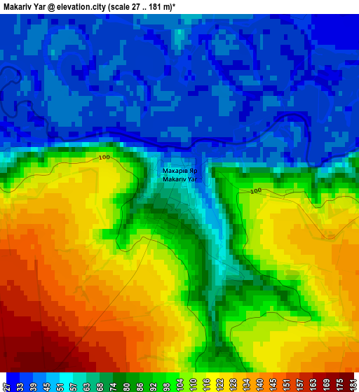
Below is the Elevation map of Makariv Yar, which displays elevation range with different colors. Scale of the first map is from 27 to 181 m (89 to 594 ft) with average elevation of 83.9 meters (=275 ft) [note 1]
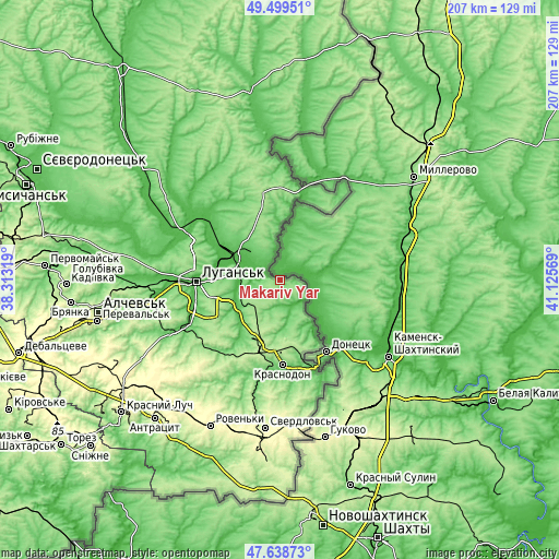
These maps also provides idea of topography and contour of this city, they are displayed at different zoom levels. More info about maps, scale and edge coordinates you can find below images.
| \ | Map #1 | Topo.Map |
| Scale [m] | 27..181 m | × |
| Scale [ft] | 89..594 ft | × |
| Average | 83.9 m = 275 ft | × |
| Width | 6.47 km = 4 mi | 206.9 km = 128.6 mi |
| Height | 6.47 km = 4 mi | 206.9 km = 128.6 mi |
| ↑Max Latitude | 48.606746° | 49.49951° |
| Latitude at center | 48.57768° | 48.57768° |
| ↓Min Latitude | 48.548597° | 47.63873° |
| ← Min Longitude | 39.675495° | 38.31319° |
| Longitude center | 39.71944° | 39.71944° |
| →Max Longitude | 39.763385° | 41.12569° |
Nearby cities:
Cities around Makariv Yar sort by population:
• Luhansk elevation 103 m
29.6 km,  267°
267°
• Sorokyne 143 m
31.8 km,  177°
177°
• Molodohvardiys’k 215 m
26.3 km,  190°
190°
• Lutuhyne 119 m
41.1 km,  242°
242°
• Shchastya 45 m
40.1 km,  296°
296°
• Stanytsya Luhans’ka 45 m
19.6 km, 295°
• Rozkishne 55 m
33.9 km,  253°
253°
• Teple 184 m
31.7 km,  201°
201°
• Uralo-Kavkaz 109 m
29.2 km,  167°
167°
• Simeykyne 199 m
31.1 km,  206°
206°
• Lenina 182 m
45.4 km, 248°
• Buran 172 m
31.8 km, 193°
Multilingual:
 En español:
Makariv Yar elevación 61 m.
 En France:
Makariv Yar élévation 61 m.
 Auf Deutsch:
Makariv Yar höhe über dem Meeresspiegel ist 61 m.
 На русском:
Makarov Yar, Пархоменко, Макаров Яр высота над уровнем моря 61 м
Sources and notes:
- [note 1] Map square and city borders are not equal. Map elevation data is calculated only from area inside that square.
- [src 1] Elevation data from geonames database provided with same terms of usage.
- [src 2] The elevation map of Makariv Yar is generated using elevation data from NASA's 3 arcsec (90m) resolution SRTM data.
- [src 3] Base (background) map © OpenStreetMap contributors tiles are generated by Geofabrik and OpenTopoMap.
Copyright & License:
This Makariv Yar Elevation Map is licensed under CC BY-SA. You may reuse any part from this page, if you give a proper credit by linking to this URL:
 More info on terms of use page.