Pavlohrad elevation
Pavlohrad (Dnipropetrovsk), Ukraine elevation is 70 meters and Pavlohrad elevation in feet is 230 ft above sea level [src 1]. Pavlohrad is a seat of a second-order administrative division (feature code) with elevation that is 87 meters (285 ft) smaller than average city elevation in Ukraine.
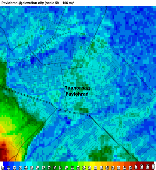
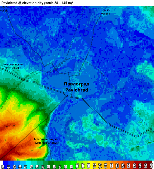
Below is the Elevation map of Pavlohrad, which displays elevation range with different colors. Scale of the first map is from 59 to 106 m (194 to 348 ft) with average elevation of 67.1 meters (=220 ft) [note 1]
These maps also provides idea of topography and contour of this city, they are displayed at different zoom levels. More info about maps, scale and edge coordinates you can find below images.
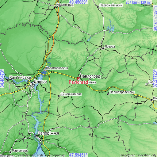
| \ | Map #1 | Map #2 | Topo.Map |
| Scale [m] | 59..106 m | 58..145 m | × |
| Scale [ft] | 194..348 ft | 190..476 ft | × |
| Average | 67.1 m = 220 ft | 72.6 m = 238 ft | × |
| Width | 6.47 km = 4 mi | 12.94 km = 8 mi | 207.1 km = 128.7 mi |
| Height | 6.47 km = 4 mi | 12.94 km = 8 mi | 207.1 km = 128.7 mi |
| ↑Max Latitude | 48.563351° | 48.592425° | 49.45689° |
| Latitude at center | 48.53426° | 48.53426° | 48.53426° |
| ↓Min Latitude | 48.505152° | 48.476028° | 47.59451° |
| ← Min Longitude | 35.827035° | 35.783089° | 34.46473° |
| Longitude center | 35.87098° | 35.87098° | 35.87098° |
| →Max Longitude | 35.914925° | 35.958871° | 37.27723° |
Nearby cities:
Cities around Pavlohrad sort by population:
• Novomoskovs’k elevation 58 m
47.4 km,  284°
284°
• Lozova 185 m
51.3 km,  39°
39°
• Synel’nykove 171 m
35.3 km,  227°
227°
• Pidhorodne 56 m
56.4 km,  274°
274°
• Petropavlivka 78 m
42.6 km,  101°
101°
• Panyutyne 172 m
53.7 km,  33°
33°
• Hubynykha 126 m
54.6 km,  304°
304°
• Melioratyvne 72 m
35.2 km,  287°
287°
• Aviatorske 145 m
61.1 km,  252°
252°
• Kaydaki 134 m
57.8 km, 252°
• Vasyl’kivka 77 m
38.1 km,  162°
162°
• Yur”yivka 77 m
25.1 km, 25°
Multilingual:
 En español:
Pavlohrad elevación 70 m.
 En France:
Pavlohrad élévation 70 m.
 Auf Deutsch:
Pawlohrad höhe über dem Meeresspiegel ist 70 m.

Sources and notes:
- [note 1] Map square and city borders are not equal. Map elevation data is calculated only from area inside that square.
- [src 1] Elevation data from geonames database provided with same terms of usage.
- [src 2] The elevation map of Pavlohrad is generated using elevation data from NASA's 3 arcsec (90m) resolution SRTM data.
- [src 3] Base (background) map © OpenStreetMap contributors tiles are generated by Geofabrik and OpenTopoMap.
Copyright & License:
This Pavlohrad Elevation Map is licensed under CC BY-SA. You may reuse any part from this page, if you give a proper credit by linking to this URL:
 More info on terms of use page.