Piskivka elevation
Piskivka (Kyiv), Ukraine elevation is 139 meters and Piskivka elevation in feet is 456 ft above sea level [src 1]. Piskivka is a populated place (feature code) with elevation that is 18 meters (59 ft) smaller than average city elevation in Ukraine.
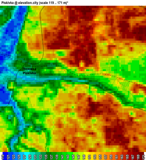
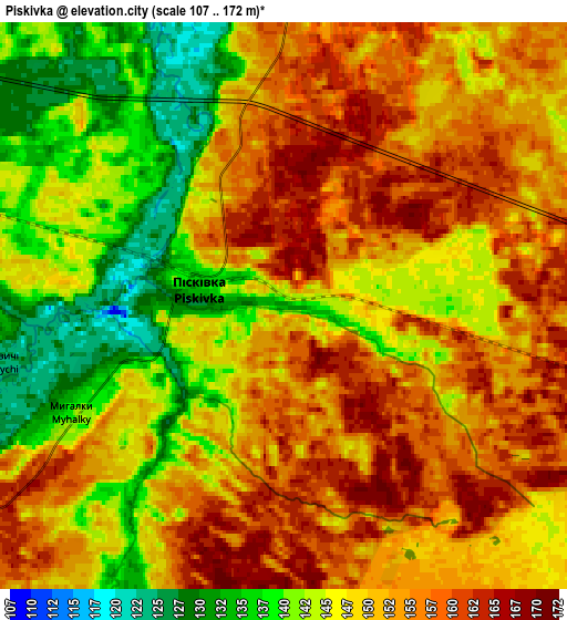
Below is the Elevation map of Piskivka, which displays elevation range with different colors. Scale of the first map is from 119 to 171 m (390 to 561 ft) with average elevation of 150 meters (=492 ft) [note 1]
These maps also provides idea of topography and contour of this city, they are displayed at different zoom levels. More info about maps, scale and edge coordinates you can find below images.
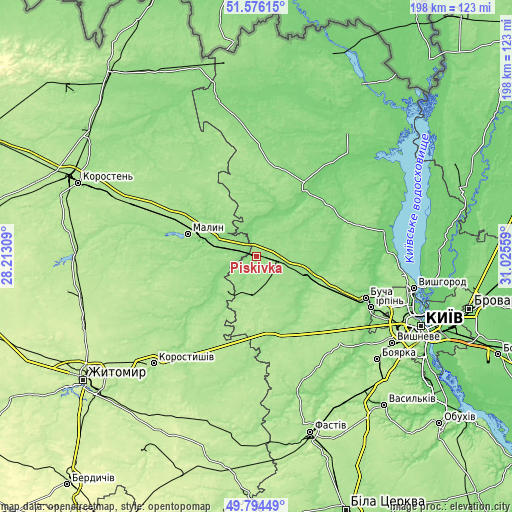
| \ | Map #1 | Map #2 | Topo.Map |
| Scale [m] | 119..171 m | 107..172 m | × |
| Scale [ft] | 390..561 ft | 351..564 ft | × |
| Average | 150 m = 492 ft | 149.2 m = 490 ft | × |
| Width | 6.19 km = 3.8 mi | 12.38 km = 7.7 mi | 198.1 km = 123.1 mi |
| Height | 6.19 km = 3.8 mi | 12.38 km = 7.7 mi | 198.1 km = 123.1 mi |
| ↑Max Latitude | 50.72161° | 50.749423° | 51.57615° |
| Latitude at center | 50.69378° | 50.69378° | 50.69378° |
| ↓Min Latitude | 50.665934° | 50.638071° | 49.79449° |
| ← Min Longitude | 29.575395° | 29.531449° | 28.21309° |
| Longitude center | 29.61934° | 29.61934° | 29.61934° |
| →Max Longitude | 29.663285° | 29.707231° | 31.02559° |
Nearby cities:
Cities around Piskivka sort by population:
• Malyn elevation 161 m
28.2 km,  288°
288°
• Radomyshl 163 m
35.2 km,  231°
231°
• Borodianka 139 m
21.9 km,  104°
104°
• Makariv 168 m
28.9 km,  152°
152°
• Ivankiv 138 m
33.4 km,  35°
35°
• Vorzel’ 166 m
41.2 km,  113°
113°
• Stavyshche 181 m
33.2 km,  191°
191°
• Klavdiyevo-Tarasove 168 m
30.2 km, 113°
• Katyuzhanka 139 m
38.5 km,  71°
71°
• Horodok 159 m
15.7 km, 225°
• Kodra 146 m
11.8 km,  201°
201°
• Bila Krynytsya 137 m
12.1 km,  240°
240°
Multilingual:
 En español:
Piskivka elevación 139 m.
 En France:
Piskivka élévation 139 m.
 Auf Deutsch:
Piskivka höhe über dem Meeresspiegel ist 139 m.

Sources and notes:
- [note 1] Map square and city borders are not equal. Map elevation data is calculated only from area inside that square.
- [src 1] Elevation data from geonames database provided with same terms of usage.
- [src 2] The elevation map of Piskivka is generated using elevation data from NASA's 3 arcsec (90m) resolution SRTM data.
- [src 3] Base (background) map © OpenStreetMap contributors tiles are generated by Geofabrik and OpenTopoMap.
Copyright & License:
This Piskivka Elevation Map is licensed under CC BY-SA. You may reuse any part from this page, if you give a proper credit by linking to this URL:
 More info on terms of use page.