Radomyshl elevation
Radomyshl (Zhytomyr, Radomyshl Raion), Ukraine elevation is 163 meters and Radomyshl elevation in feet is 535 ft above sea level [src 1]. Radomyshl is a seat of a second-order administrative division (feature code) with elevation that is 6 meters (20 ft) bigger than average city elevation in Ukraine.
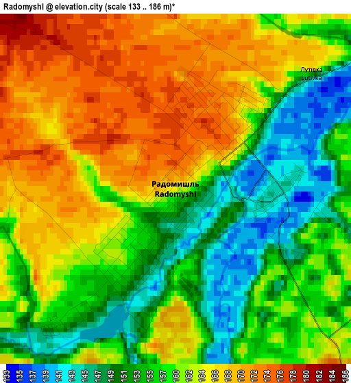
Below is the Elevation map of Radomyshl, which displays elevation range with different colors. Scale of the first map is from 133 to 186 m (436 to 610 ft) with average elevation of 160.4 meters (=526 ft) [note 1]
These maps also provides idea of topography and contour of this city, they are displayed at different zoom levels. More info about maps, scale and edge coordinates you can find below images.
| \ | Map #1 | Map #2 | Topo.Map |
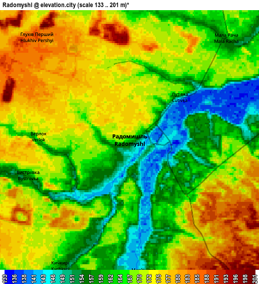
| Scale [m] | 133..186 m | 133..201 m | × |
| Scale [ft] | 436..610 ft | 436..659 ft | × |
| Average | 160.4 m = 526 ft | 168 m = 551 ft | × |
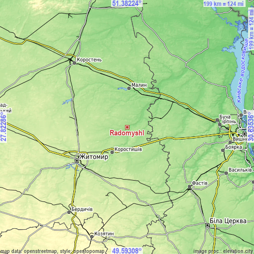
| Width | 6.22 km = 3.9 mi | 12.43 km = 7.7 mi | 198.9 km = 123.6 mi |
| Height | 6.22 km = 3.9 mi | 12.43 km = 7.7 mi | 198.9 km = 123.6 mi |
| ↑Max Latitude | 50.524077° | 50.552007° | 51.38224° |
| Latitude at center | 50.49613° | 50.49613° | 50.49613° |
| ↓Min Latitude | 50.468167° | 50.440187° | 49.59308° |
| ← Min Longitude | 29.185165° | 29.141219° | 27.82286° |
| Longitude center | 29.22911° | 29.22911° | 29.22911° |
| →Max Longitude | 29.273055° | 29.317001° | 30.63536° |
Nearby cities:
Cities around Radomyshl sort by population:
• Malyn elevation 161 m
30.7 km,  1°
1°
• Korostyshiv 180 m
23.4 km,  211°
211°
• Makariv 168 m
41.3 km,  94°
94°
• Cherniakhiv 226 m
39.8 km,  263°
263°
• Stavyshche 181 m
23.7 km,  116°
116°
• Piskivka 139 m
35.2 km,  51°
51°
• Brusyliv 166 m
31.6 km,  138°
138°
• Horodok 159 m
19.7 km,  56°
56°
• Chopovychi 168 m
42.2 km,  332°
332°
• Holovyne 205 m
28.7 km, 264°
• Kodra 146 m
25.7 km, 64°
• Bila Krynytsya 137 m
23.4 km, 46°
Multilingual:
 En español:
Radomyshl elevación 163 m.
 En France:
Radomyshl élévation 163 m.
 Auf Deutsch:
Radomyshl höhe über dem Meeresspiegel ist 163 m.

Sources and notes:
- [note 1] Map square and city borders are not equal. Map elevation data is calculated only from area inside that square.
- [src 1] Elevation data from geonames database provided with same terms of usage.
- [src 2] The elevation map of Radomyshl is generated using elevation data from NASA's 3 arcsec (90m) resolution SRTM data.
- [src 3] Base (background) map © OpenStreetMap contributors tiles are generated by Geofabrik and OpenTopoMap.
Copyright & License:
This Radomyshl Elevation Map is licensed under CC BY-SA. You may reuse any part from this page, if you give a proper credit by linking to this URL:
 More info on terms of use page.