Prymors’k elevation
Prymors’k (Zaporizhia, Prymorsk Raion), Ukraine elevation is 13 meters and Prymors’k elevation in feet is 43 ft above sea level [src 1]. Prymors’k is a seat of a second-order administrative division (feature code) with elevation that is 144 meters (472 ft) smaller than average city elevation in Ukraine.
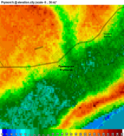
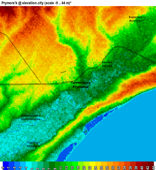
Below is the Elevation map of Prymors’k, which displays elevation range with different colors. Scale of the first map is from -9 to 36 m (-30 to 118 ft) with average elevation of 14.2 meters (=47 ft) [note 1]
These maps also provides idea of topography and contour of this city, they are displayed at different zoom levels. More info about maps, scale and edge coordinates you can find below images.
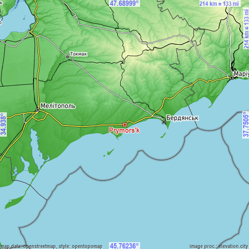
| \ | Map #1 | Map #2 | Topo.Map |
| Scale [m] | -9..36 m | -9..44 m | × |
| Scale [ft] | -30..118 ft | -30..144 ft | × |
| Average | 14.2 m = 47 ft | 14.4 m = 47 ft | × |
| Width | 6.7 km = 4.2 mi | 13.4 km = 8.3 mi | 214.3 km = 133.2 mi |
| Height | 6.7 km = 4.2 mi | 13.4 km = 8.3 mi | 214.3 km = 133.2 mi |
| ↑Max Latitude | 46.764901° | 46.794995° | 47.68999° |
| Latitude at center | 46.73479° | 46.73479° | 46.73479° |
| ↓Min Latitude | 46.704663° | 46.674518° | 45.76236° |
| ← Min Longitude | 36.300305° | 36.256359° | 34.938° |
| Longitude center | 36.34425° | 36.34425° | 36.34425° |
| →Max Longitude | 36.388195° | 36.432141° | 37.7505° |
Nearby cities:
Cities around Prymors’k sort by population:
• Berdyansk elevation 31 m
34.8 km,  84°
84°
• Kostyantynivka 7 m
70.8 km,  277°
277°
• Kuybysheve 201 m
73 km,  18°
18°
• Voznesenka 16 m
68.7 km, 282°
• Terpinnya 65 m
74.9 km,  290°
290°
• Osypenko 18 m
41.6 km,  61°
61°
• Rozivka 63 m
49.1 km,  297°
297°
• Urzuf 8 m
60.9 km,  70°
70°
• Novovasylivka 26 m
46.4 km, 283°
• Komysh-Zorya 230 m
71 km, 21°
• Chernihivka 105 m
53.5 km,  344°
344°
• Pryazovs’ke 21 m
53.5 km,  269°
269°
Multilingual:
 En español:
Prymors’k elevación 13 m.
 En France:
Prymors’k élévation 13 m.
 Auf Deutsch:
Prymors’k höhe über dem Meeresspiegel ist 13 m.
 На русском:
Primorsk, Primorskoye, Приморск высота над уровнем моря 13 м
Sources and notes:
- [note 1] Map square and city borders are not equal. Map elevation data is calculated only from area inside that square.
- [src 1] Elevation data from geonames database provided with same terms of usage.
- [src 2] The elevation map of Prymors’k is generated using elevation data from NASA's 3 arcsec (90m) resolution SRTM data.
- [src 3] Base (background) map © OpenStreetMap contributors tiles are generated by Geofabrik and OpenTopoMap.
Copyright & License:
This Prymors’k Elevation Map is licensed under CC BY-SA. You may reuse any part from this page, if you give a proper credit by linking to this URL:
 More info on terms of use page.