Silets’ elevation
Silets’ (Lviv), Ukraine elevation is 194 meters and Silets’ elevation in feet is 636 ft above sea level [src 1]. Silets’ is a populated place (feature code) with elevation that is 37 meters (121 ft) bigger than average city elevation in Ukraine.
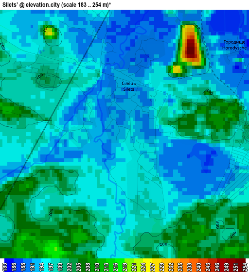
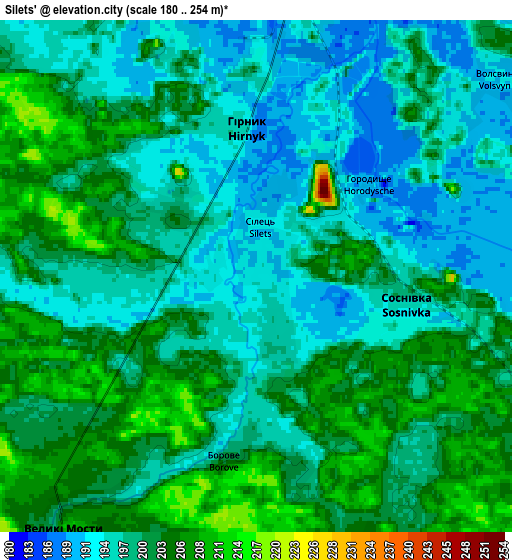
Below is the Elevation map of Silets’, which displays elevation range with different colors. Scale of the first map is from 183 to 254 m (600 to 833 ft) with average elevation of 197 meters (=646 ft) [note 1]
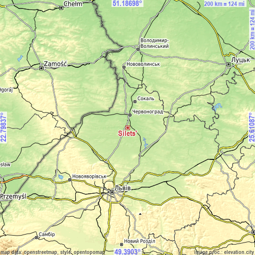
These maps also provides idea of topography and contour of this city, they are displayed at different zoom levels. More info about maps, scale and edge coordinates you can find below images.
| \ | Map #1 | Map #2 | Topo.Map |
| Scale [m] | 183..254 m | 180..254 m | × |
| Scale [ft] | 600..833 ft | 591..833 ft | × |
| Average | 197 m = 646 ft | 199.4 m = 654 ft | × |
| Width | 6.24 km = 3.9 mi | 12.49 km = 7.8 mi | 199.8 km = 124.1 mi |
| Height | 6.24 km = 3.9 mi | 12.49 km = 7.8 mi | 199.8 km = 124.1 mi |
| ↑Max Latitude | 50.325184° | 50.353232° | 51.18698° |
| Latitude at center | 50.29712° | 50.29712° | 50.29712° |
| ↓Min Latitude | 50.269039° | 50.240942° | 49.3903° |
| ← Min Longitude | 24.160675° | 24.116729° | 22.79837° |
| Longitude center | 24.20462° | 24.20462° | 24.20462° |
| →Max Longitude | 24.248565° | 24.292511° | 25.61087° |
Nearby cities:
Cities around Silets’ sort by population:
• Chervonohrad elevation 195 m
10.7 km,  11°
11°
• Sokal’ 198 m
20.5 km,  15°
15°
• Zhovkva 232 m
31.3 km,  211°
211°
• Staryy Dobrotvir 201 m
14.3 km,  120°
120°
• Kulykiv 258 m
36.4 km,  194°
194°
• Belz 200 m
17 km,  303°
303°
• Hlyns'k 259 m
34.1 km,  219°
219°
• Richky 235 m
39.7 km,  266°
266°
• Uhniv 211 m
33.3 km,  283°
283°
• Ivanychi 204 m
39.6 km, 16°
• Radekhiv 227 m
31.2 km,  92°
92°
• Kamianka-Buzka 215 m
23.4 km,  154°
154°
Multilingual:
 En español:
Silets’ elevación 194 m.
 En France:
Silets’ élévation 194 m.


Sources and notes:
- [note 1] Map square and city borders are not equal. Map elevation data is calculated only from area inside that square.
- [src 1] Elevation data from geonames database provided with same terms of usage.
- [src 2] The elevation map of Silets’ is generated using elevation data from NASA's 3 arcsec (90m) resolution SRTM data.
- [src 3] Base (background) map © OpenStreetMap contributors tiles are generated by Geofabrik and OpenTopoMap.
Copyright & License:
This Silets’ Elevation Map is licensed under CC BY-SA. You may reuse any part from this page, if you give a proper credit by linking to this URL:
 More info on terms of use page.