Slavske elevation
Slavske (Lviv), Ukraine elevation is 588 meters and Slavske elevation in feet is 1929 ft above sea level [src 1]. Slavske is a populated place (feature code) with elevation that is 431 meters (1414 ft) bigger than average city elevation in Ukraine.
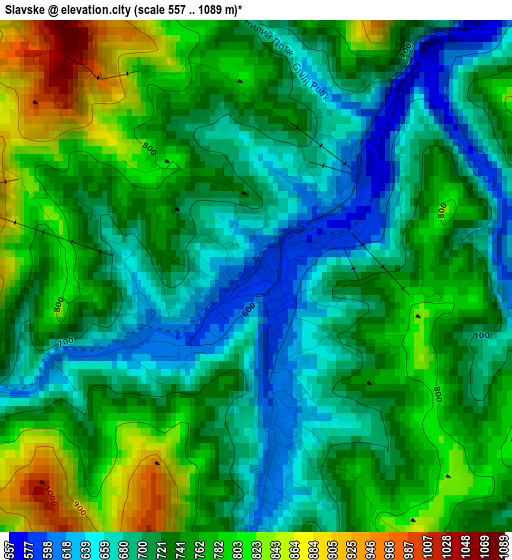
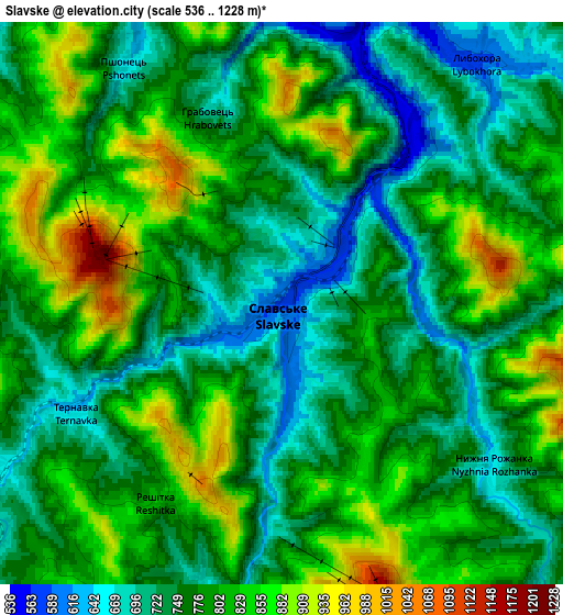
Below is the Elevation map of Slavske, which displays elevation range with different colors. Scale of the first map is from 557 to 1089 m (1827 to 3573 ft) with average elevation of 733.9 meters (=2408 ft) [note 1]
These maps also provides idea of topography and contour of this city, they are displayed at different zoom levels. More info about maps, scale and edge coordinates you can find below images.
| \ | Map #1 | Map #2 | Topo.Map |
| Scale [m] | 557..1089 m | 536..1228 m | × |
| Scale [ft] | 1827..3573 ft | 1759..4029 ft | × |
| Average | 733.9 m = 2408 ft | 780 m = 2559 ft | × |
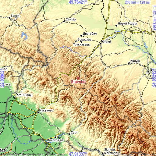
| Width | 6.43 km = 4 mi | 12.86 km = 8 mi | 205.8 km = 127.9 mi |
| Height | 6.43 km = 4 mi | 12.86 km = 8 mi | 205.8 km = 127.9 mi |
| ↑Max Latitude | 48.876251° | 48.905145° | 49.76421° |
| Latitude at center | 48.84734° | 48.84734° | 48.84734° |
| ↓Min Latitude | 48.818413° | 48.789469° | 47.91337° |
| ← Min Longitude | 23.401925° | 23.357979° | 22.03962° |
| Longitude center | 23.44587° | 23.44587° | 23.44587° |
| →Max Longitude | 23.489815° | 23.533761° | 24.85212° |
Nearby cities:
Cities around Slavske sort by population:
• Bolekhiv elevation 365 m
39.1 km,  51°
51°
• Mizhhirya 452 m
36.2 km,  173°
173°
• Skole 439 m
21.7 km,  13°
13°
• Volovets 529 m
24.4 km,  231°
231°
• Synevyr 630 m
42.1 km,  161°
161°
• Verkhnie Synevydne 379 m
30.3 km,  20°
20°
• Lysychovo 337 m
40.6 km,  196°
196°
• Bereznyky 313 m
40.6 km, 204°
• Tukhlia 542 m
7.5 km, 15°
• Synevyrska Poliana 802 m
34.2 km,  148°
148°
• Verchnia Rozhanka 707 m
9 km, 145°
• Pylypets 698 m
24.1 km,  209°
209°
Multilingual:
 En español:
Slavske elevación 588 m.
 En France:
Slavske élévation 588 m.


Sources and notes:
- [note 1] Map square and city borders are not equal. Map elevation data is calculated only from area inside that square.
- [src 1] Elevation data from geonames database provided with same terms of usage.
- [src 2] The elevation map of Slavske is generated using elevation data from NASA's 3 arcsec (90m) resolution SRTM data.
- [src 3] Base (background) map © OpenStreetMap contributors tiles are generated by Geofabrik and OpenTopoMap.
Copyright & License:
This Slavske Elevation Map is licensed under CC BY-SA. You may reuse any part from this page, if you give a proper credit by linking to this URL:
 More info on terms of use page.