Solotvyno elevation
Solotvyno (Transcarpathia), Ukraine elevation is 286 meters and Solotvyno elevation in feet is 938 ft above sea level [src 1]. Solotvyno is a populated place (feature code) with elevation that is 129 meters (423 ft) bigger than average city elevation in Ukraine.
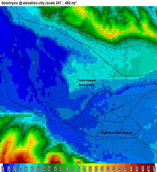
Below is the Elevation map of Solotvyno, which displays elevation range with different colors. Scale of the first map is from 247 to 482 m (810 to 1581 ft) with average elevation of 289.9 meters (=951 ft) [note 1]
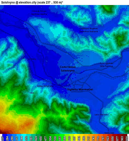
These maps also provides idea of topography and contour of this city, they are displayed at different zoom levels. More info about maps, scale and edge coordinates you can find below images.
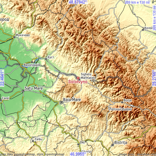
| \ | Map #1 | Map #2 | Topo.Map |
| Scale [m] | 247..482 m | 237..930 m | × |
| Scale [ft] | 810..1581 ft | 778..3051 ft | × |
| Average | 289.9 m = 951 ft | 353.7 m = 1160 ft | × |
| Width | 6.55 km = 4.1 mi | 13.09 km = 8.1 mi | 209.5 km = 130.2 mi |
| Height | 6.55 km = 4.1 mi | 13.09 km = 8.1 mi | 209.5 km = 130.2 mi |
| ↑Max Latitude | 47.975468° | 48.004878° | 48.87942° |
| Latitude at center | 47.94604° | 47.94604° | 47.94604° |
| ↓Min Latitude | 47.916596° | 47.887135° | 46.9955° |
| ← Min Longitude | 23.826405° | 23.782459° | 22.4641° |
| Longitude center | 23.87035° | 23.87035° | 23.87035° |
| →Max Longitude | 23.914295° | 23.958241° | 25.2766° |
Nearby cities:
Cities around Solotvyno sort by population:
• Rakhiv elevation 439 m
27.3 km,  64°
64°
• Tyachiv 213 m
23.5 km,  288°
288°
• Dubove 383 m
25.2 km,  3°
3°
• Bushtyno 206 m
30.9 km, 292°
• Vyshkovo 192 m
35.3 km, 288°
• Kalyny 353 m
21.7 km, 0°
• Serednye Vodyane 272 m
5 km,  37°
37°
• Drahovo 368 m
40.1 km,  323°
323°
• Lazi 493 m
30.2 km, 63°
• Neresnytsya 304 m
20.7 km,  337°
337°
• Bohdan 542 m
37.4 km,  73°
73°
• Kvasy 532 m
37.9 km,  53°
53°
Multilingual:
 En español:
Solotvyno elevación 286 m.
 En France:
Solotvyno élévation 286 m.
 Auf Deutsch:
Solotvyno höhe über dem Meeresspiegel ist 286 m.

Sources and notes:
- [note 1] Map square and city borders are not equal. Map elevation data is calculated only from area inside that square.
- [src 1] Elevation data from geonames database provided with same terms of usage.
- [src 2] The elevation map of Solotvyno is generated using elevation data from NASA's 3 arcsec (90m) resolution SRTM data.
- [src 3] Base (background) map © OpenStreetMap contributors tiles are generated by Geofabrik and OpenTopoMap.
Copyright & License:
This Solotvyno Elevation Map is licensed under CC BY-SA. You may reuse any part from this page, if you give a proper credit by linking to this URL:
 More info on terms of use page.