Tyachiv elevation
Tyachiv (Transcarpathia), Ukraine elevation is 213 meters and Tyachiv elevation in feet is 699 ft above sea level [src 1]. Tyachiv is a seat of a second-order administrative division (feature code) with elevation that is 56 meters (184 ft) bigger than average city elevation in Ukraine.
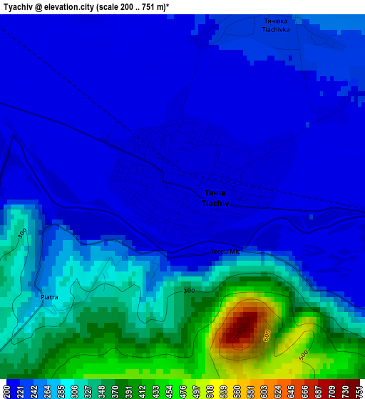
Below is the Elevation map of Tyachiv, which displays elevation range with different colors. Scale of the first map is from 200 to 751 m (656 to 2464 ft) with average elevation of 270.6 meters (=888 ft) [note 1]
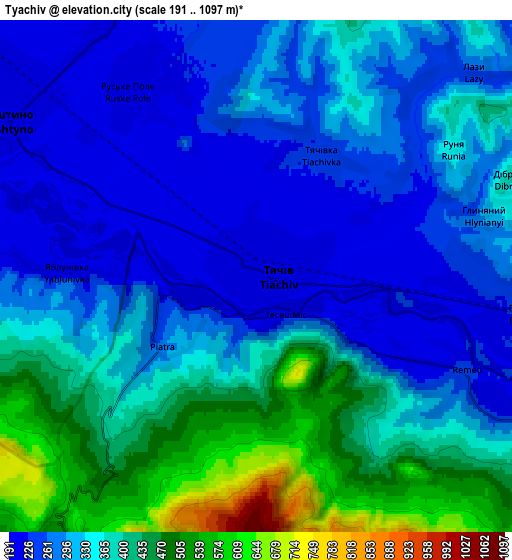
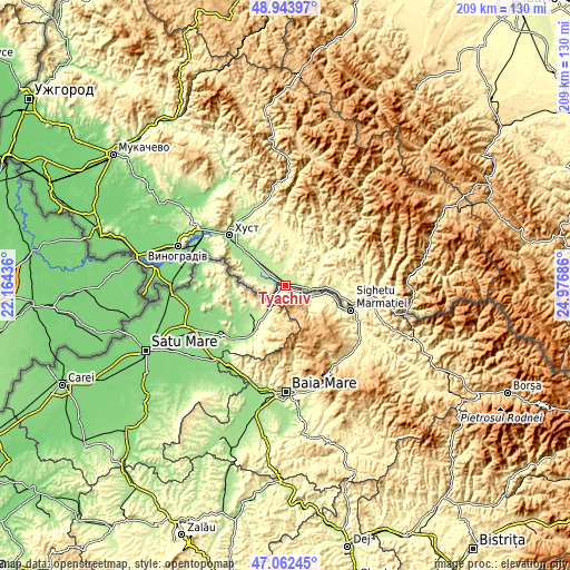
These maps also provides idea of topography and contour of this city, they are displayed at different zoom levels. More info about maps, scale and edge coordinates you can find below images.
| \ | Map #1 | Map #2 | Topo.Map |
| Scale [m] | 200..751 m | 191..1097 m | × |
| Scale [ft] | 656..2464 ft | 627..3599 ft | × |
| Average | 270.6 m = 888 ft | 339.7 m = 1115 ft | × |
| Width | 6.54 km = 4.1 mi | 13.08 km = 8.1 mi | 209.2 km = 130 mi |
| Height | 6.54 km = 4.1 mi | 13.08 km = 8.1 mi | 209.2 km = 130 mi |
| ↑Max Latitude | 48.04118° | 48.070553° | 48.94397° |
| Latitude at center | 48.01179° | 48.01179° | 48.01179° |
| ↓Min Latitude | 47.982383° | 47.95296° | 47.06245° |
| ← Min Longitude | 23.526665° | 23.482719° | 22.16436° |
| Longitude center | 23.57061° | 23.57061° | 23.57061° |
| →Max Longitude | 23.614555° | 23.658501° | 24.97686° |
Nearby cities:
Cities around Tyachiv sort by population:
• Khust elevation 169 m
27.4 km,  312°
312°
• Solotvyno 286 m
23.5 km,  108°
108°
• Dubove 383 m
29.6 km,  53°
53°
• Bushtyno 206 m
7.7 km,  304°
304°
• Vyshkovo 192 m
11.9 km,  290°
290°
• Kalyny 353 m
26.7 km,  57°
57°
• Serednye Vodyane 272 m
25.5 km,  97°
97°
• Iza 183 m
28.9 km,  321°
321°
• Drahovo 368 m
25 km,  356°
356°
• Neresnytsya 304 m
18.7 km, 50°
• Nyzhnye Selyshche 236 m
22.7 km,  336°
336°
• Kopashnovo 241 m
24 km, 344°
Multilingual:
 En español:
Tyachiv elevación 213 m.
 En France:
Tyachiv élévation 213 m.


Sources and notes:
- [note 1] Map square and city borders are not equal. Map elevation data is calculated only from area inside that square.
- [src 1] Elevation data from geonames database provided with same terms of usage.
- [src 2] The elevation map of Tyachiv is generated using elevation data from NASA's 3 arcsec (90m) resolution SRTM data.
- [src 3] Base (background) map © OpenStreetMap contributors tiles are generated by Geofabrik and OpenTopoMap.
Copyright & License:
This Tyachiv Elevation Map is licensed under CC BY-SA. You may reuse any part from this page, if you give a proper credit by linking to this URL:
 More info on terms of use page.