Troyits’ke elevation
Troyits’ke (Luhansk), Ukraine elevation is 111 meters and Troyits’ke elevation in feet is 364 ft above sea level [src 1]. Troyits’ke is a seat of a second-order administrative division (feature code) with elevation that is 46 meters (151 ft) smaller than average city elevation in Ukraine.
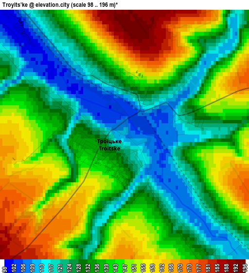
Below is the Elevation map of Troyits’ke, which displays elevation range with different colors. Scale of the first map is from 98 to 196 m (322 to 643 ft) with average elevation of 139.1 meters (=456 ft) [note 1]
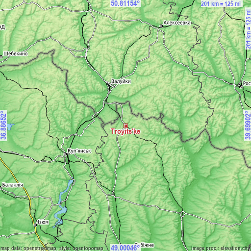
These maps also provides idea of topography and contour of this city, they are displayed at different zoom levels. More info about maps, scale and edge coordinates you can find below images.
| \ | Map #1 | Topo.Map |
| Scale [m] | 98..196 m | × |
| Scale [ft] | 322..643 ft | × |
| Average | 139.1 m = 456 ft | × |
| Width | 6.29 km = 3.9 mi | 201.4 km = 125.1 mi |
| Height | 6.29 km = 3.9 mi | 201.4 km = 125.1 mi |
| ↑Max Latitude | 49.942789° | 50.81154° |
| Latitude at center | 49.9145° | 49.9145° |
| ↓Min Latitude | 49.886194° | 49.00046° |
| ← Min Longitude | 38.248825° | 36.88652° |
| Longitude center | 38.29277° | 38.29277° |
| →Max Longitude | 38.336715° | 39.69902° |
Nearby cities:
Cities around Troyits’ke sort by population:
• Kupjansk elevation 92 m
53.6 km,  244°
244°
• Kivsharivka 95 m
53.7 km,  234°
234°
• Svatove 70 m
57 km,  190°
190°
• Novopskov 69 m
70.4 km,  125°
125°
• Bilokurakyne 88 m
52.7 km,  143°
143°
• Borova 88 m
76.8 km,  219°
219°
• Velykyy Burluk 147 m
67 km,  284°
284°
• Dvorichna 86 m
44.3 km,  260°
260°
• Prykolotne 213 m
73.1 km,  292°
292°
• Nyzhnya Duvanka 79 m
37.7 km, 193°
• Lozno-Oleksandrivka 93 m
33.2 km,  104°
104°
• Pavlivka 94 m
45.3 km, 138°
Multilingual:
 En español:
Troyits’ke elevación 111 m.
 En France:
Troyits’ke élévation 111 m.
 Auf Deutsch:
Troyits’ke höhe über dem Meeresspiegel ist 111 m.

Sources and notes:
- [note 1] Map square and city borders are not equal. Map elevation data is calculated only from area inside that square.
- [src 1] Elevation data from geonames database provided with same terms of usage.
- [src 2] The elevation map of Troyits’ke is generated using elevation data from NASA's 3 arcsec (90m) resolution SRTM data.
- [src 3] Base (background) map © OpenStreetMap contributors tiles are generated by Geofabrik and OpenTopoMap.
Copyright & License:
This Troyits’ke Elevation Map is licensed under CC BY-SA. You may reuse any part from this page, if you give a proper credit by linking to this URL:
 More info on terms of use page.