Zhashkiv elevation
Zhashkiv (Cherkasy), Ukraine elevation is 236 meters and Zhashkiv elevation in feet is 774 ft above sea level [src 1]. Zhashkiv is a seat of a second-order administrative division (feature code) with elevation that is 79 meters (259 ft) bigger than average city elevation in Ukraine.
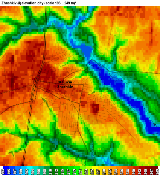
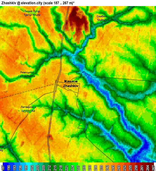
Below is the Elevation map of Zhashkiv, which displays elevation range with different colors. Scale of the first map is from 193 to 249 m (633 to 817 ft) with average elevation of 225.2 meters (=739 ft) [note 1]
These maps also provides idea of topography and contour of this city, they are displayed at different zoom levels. More info about maps, scale and edge coordinates you can find below images.
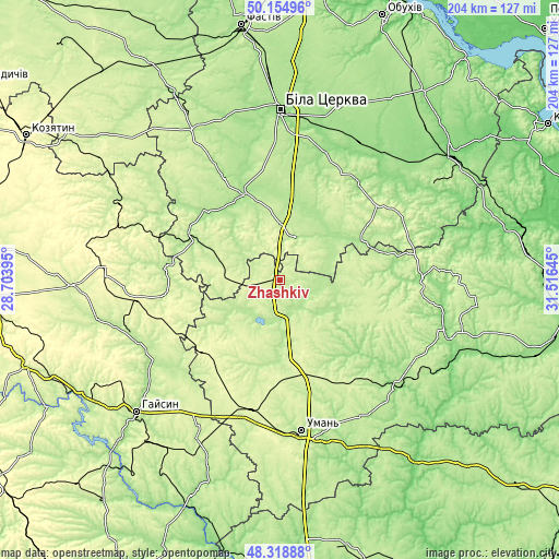
| \ | Map #1 | Map #2 | Topo.Map |
| Scale [m] | 193..249 m | 187..267 m | × |
| Scale [ft] | 633..817 ft | 614..876 ft | × |
| Average | 225.2 m = 739 ft | 228.9 m = 751 ft | × |
| Width | 6.38 km = 4 mi | 12.76 km = 7.9 mi | 204.2 km = 126.9 mi |
| Height | 6.38 km = 4 mi | 12.76 km = 7.9 mi | 204.1 km = 126.8 mi |
| ↑Max Latitude | 49.27413° | 49.302793° | 50.15496° |
| Latitude at center | 49.24545° | 49.24545° | 49.24545° |
| ↓Min Latitude | 49.216753° | 49.18804° | 48.31888° |
| ← Min Longitude | 30.066255° | 30.022309° | 28.70395° |
| Longitude center | 30.1102° | 30.1102° | 30.1102° |
| →Max Longitude | 30.154145° | 30.198091° | 31.51645° |
Nearby cities:
Cities around Zhashkiv sort by population:
• Tetiiv elevation 195 m
35.4 km,  294°
294°
• Tarashcha 189 m
44.4 km,  38°
38°
• Monastyryshche 246 m
36 km,  218°
218°
• Mankivka 218 m
35.3 km,  152°
152°
• Volodarka 172 m
34.2 km,  335°
335°
• Tsibulev 228 m
26.6 km,  225°
225°
• Nove-Misto 261 m
35.8 km,  214°
214°
• Orativ 232 m
42.8 km,  261°
261°
• Roskoshnyy 240 m
15 km,  21°
21°
• Kalynove 174 m
29 km,  58°
58°
• Buky 225 m
27.3 km,  128°
128°
• Stavyshche 210 m
17.2 km, 19°
Multilingual:
 En español:
Zhashkiv elevación 236 m.
 En France:
Zhashkiv élévation 236 m.
 Auf Deutsch:
Zhashkiv höhe über dem Meeresspiegel ist 236 m.

Sources and notes:
- [note 1] Map square and city borders are not equal. Map elevation data is calculated only from area inside that square.
- [src 1] Elevation data from geonames database provided with same terms of usage.
- [src 2] The elevation map of Zhashkiv is generated using elevation data from NASA's 3 arcsec (90m) resolution SRTM data.
- [src 3] Base (background) map © OpenStreetMap contributors tiles are generated by Geofabrik and OpenTopoMap.
Copyright & License:
This Zhashkiv Elevation Map is licensed under CC BY-SA. You may reuse any part from this page, if you give a proper credit by linking to this URL:
 More info on terms of use page.