Kostochkovka elevation
Kostochkovka (Republic of Crimea, Nizhnegorskiy rayon), Ukraine elevation is 51 meters and Kostochkovka elevation in feet is 167 ft above sea level [src 1]. Kostochkovka is a seat of a third-order administrative division (feature code) with elevation that is 106 meters (348 ft) smaller than average city elevation in Ukraine.
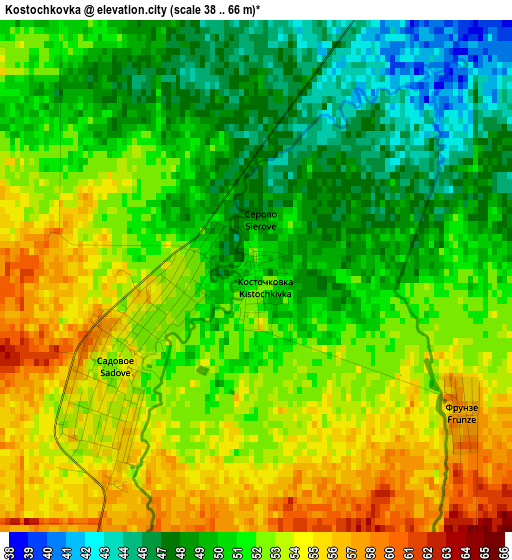
Below is the Elevation map of Kostochkovka, which displays elevation range with different colors. Scale of the first map is from 38 to 66 m (125 to 217 ft) with average elevation of 51.6 meters (=169 ft) [note 1]
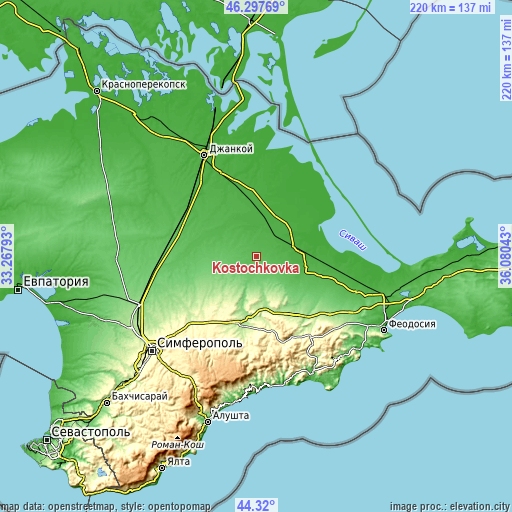
These maps also provides idea of topography and contour of this city, they are displayed at different zoom levels. More info about maps, scale and edge coordinates you can find below images.
| \ | Map #1 | Topo.Map |
| Scale [m] | 38..66 m | × |
| Scale [ft] | 125..217 ft | × |
| Average | 51.6 m = 169 ft | × |
| Width | 6.87 km = 4.3 mi | 219.9 km = 136.6 mi |
| Height | 6.87 km = 4.3 mi | 219.9 km = 136.6 mi |
| ↑Max Latitude | 45.348363° | 46.29769° |
| Latitude at center | 45.31747° | 45.31747° |
| ↓Min Latitude | 45.28656° | 44.32° |
| ← Min Longitude | 34.630235° | 33.26793° |
| Longitude center | 34.67418° | 34.67418° |
| →Max Longitude | 34.718125° | 36.08043° |
Nearby cities:
Cities around Kostochkovka sort by population:
• Sadovoye elevation 53 m
1.9 km,  244°
244°
• Zhelyabovka 30 m
11.2 km,  35°
35°
• Prudy 87 m
9 km,  165°
165°
• Zavetnoye 37 m
10.5 km,  84°
84°
• Mitrofanovka 26 m
14.9 km,  1°
1°
• Zybiny 81 m
9.2 km,  191°
191°
• Zernovoye 76 m
15.1 km,  272°
272°
• Razdol’noye 22 m
14.9 km,  70°
70°
• Zhemchuzhina 66 m
4.9 km,  195°
195°
• Chernozemnoye 25 m
15.2 km,  48°
48°
• Drofino 62 m
5.7 km,  232°
232°
• Ivanovka 37 m
7.3 km,  29°
29°
Multilingual:
 En español:
Kostochkovka elevación 51 m.
 En France:
Kostochkovka élévation 51 m.
 Auf Deutsch:
Kostochkovka höhe über dem Meeresspiegel ist 51 m.

Sources and notes:
- [note 1] Map square and city borders are not equal. Map elevation data is calculated only from area inside that square.
- [src 1] Elevation data from geonames database provided with same terms of usage.
- [src 2] The elevation map of Kostochkovka is generated using elevation data from NASA's 3 arcsec (90m) resolution SRTM data.
- [src 3] Base (background) map © OpenStreetMap contributors tiles are generated by Geofabrik and OpenTopoMap.
Copyright & License:
This Kostochkovka Elevation Map is licensed under CC BY-SA. You may reuse any part from this page, if you give a proper credit by linking to this URL:
 More info on terms of use page.