Masasi elevation
Masasi (Mtwara, Masasi Town), Tanzania elevation is 449 meters and Masasi elevation in feet is 1473 ft above sea level [src 1]. Masasi is a populated place (feature code) with elevation that is 494 meters (1621 ft) smaller than average city elevation in Tanzania.
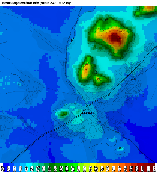
Below is the Elevation map of Masasi, which displays elevation range with different colors. Scale of the first map is from 337 to 922 m (1106 to 3025 ft) with average elevation of 413.9 meters (=1358 ft) [note 1]
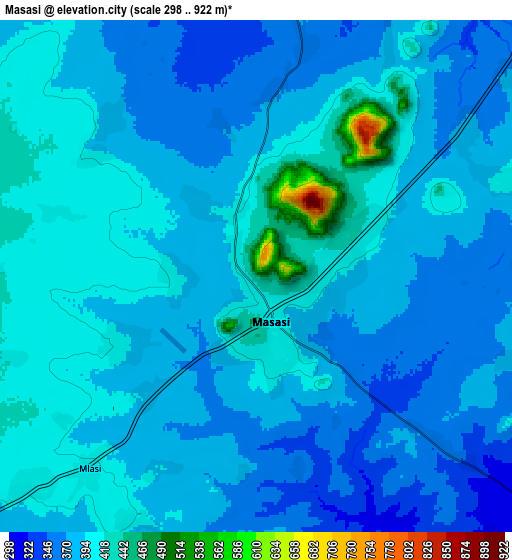
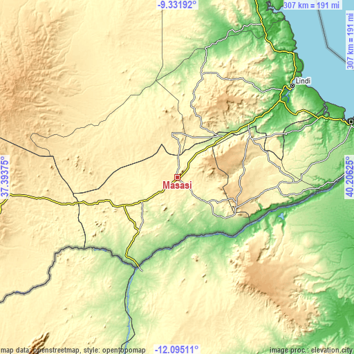
These maps also provides idea of topography and contour of this city, they are displayed at different zoom levels. More info about maps, scale and edge coordinates you can find below images.
| \ | Map #1 | Map #2 | Topo.Map |
| Scale [m] | 337..922 m | 298..922 m | × |
| Scale [ft] | 1106..3025 ft | 978..3025 ft | × |
| Average | 413.9 m = 1358 ft | 388.1 m = 1273 ft | × |
| Width | 9.6 km = 6 mi | 19.2 km = 11.9 mi | 307.2 km = 190.9 mi |
| Height | 9.6 km = 6 mi | 19.2 km = 11.9 mi | 307.3 km = 190.9 mi |
| ↑Max Latitude | -10.673488° | -10.6303° | -9.33192° |
| Latitude at center | -10.71667° | -10.71667° | -10.71667° |
| ↓Min Latitude | -10.759846° | -10.803015° | -12.09511° |
| ← Min Longitude | 38.756055° | 38.712109° | 37.39375° |
| Longitude center | 38.8° | 38.8° | 38.8° |
| →Max Longitude | 38.843945° | 38.887891° | 40.20625° |
Nearby cities:
Cities around Masasi sort by population:
• Newala Kisimani elevation 687 m
58.8 km,  116°
116°
• Lukuledi 339 m
16.7 km,  0°
0°
• Luchingu 607 m
61.7 km,  109°
109°
• Nangomba 293 m
38.6 km,  238°
238°
• Nachingwea 427 m
38.5 km,  353°
353°
• Nanganga 214 m
53.3 km,  45°
45°
• Nyangao 182 m
67.9 km, 51°
• Mahuta 478 m
72.9 km,  103°
103°
• Chiungutwa 268 m
27.3 km,  132°
132°
• Namalenga 280 m
41.8 km, 128°
• Kitangari 468 m
58.7 km,  82°
82°
• Lulindi 441 m
38.1 km, 106°
Multilingual:
 En español:
Masasi elevación 449 m.
 En France:
Masasi élévation 449 m.


Sources and notes:
- [note 1] Map square and city borders are not equal. Map elevation data is calculated only from area inside that square.
- [src 1] Elevation data from geonames database provided with same terms of usage.
- [src 2] The elevation map of Masasi is generated using elevation data from NASA's 3 arcsec (90m) resolution SRTM data.
- [src 3] Base (background) map © OpenStreetMap contributors tiles are generated by Geofabrik and OpenTopoMap.
Copyright & License:
This Masasi Elevation Map is licensed under CC BY-SA. You may reuse any part from this page, if you give a proper credit by linking to this URL:
 More info on terms of use page.