Nangomba elevation
Nangomba (Mtwara, Nanyumbu District), Tanzania elevation is 293 meters and Nangomba elevation in feet is 961 ft above sea level [src 1]. Nangomba is a populated place (feature code) with elevation that is 650 meters (2133 ft) smaller than average city elevation in Tanzania.
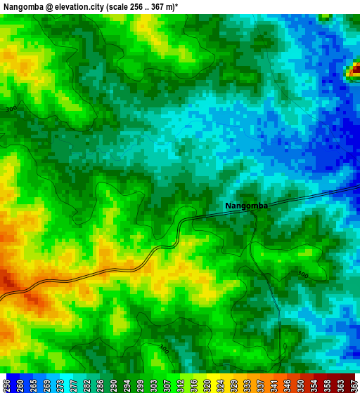
Below is the Elevation map of Nangomba, which displays elevation range with different colors. Scale of the first map is from 256 to 367 m (840 to 1204 ft) with average elevation of 295.3 meters (=969 ft) [note 1]
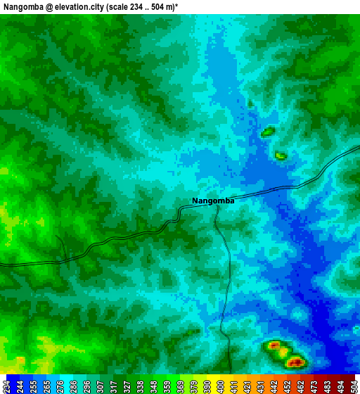
These maps also provides idea of topography and contour of this city, they are displayed at different zoom levels. More info about maps, scale and edge coordinates you can find below images.
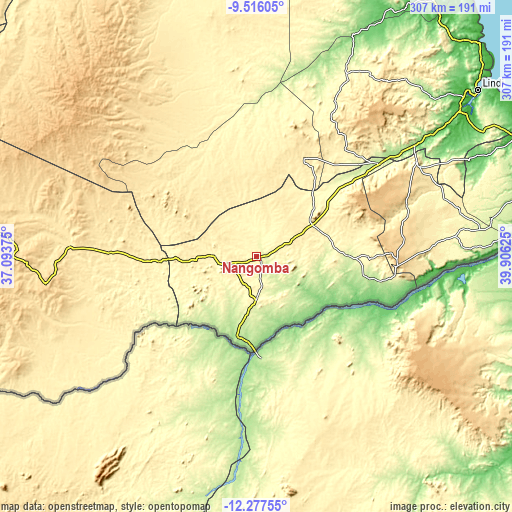
| \ | Map #1 | Map #2 | Topo.Map |
| Scale [m] | 256..367 m | 234..504 m | × |
| Scale [ft] | 840..1204 ft | 768..1654 ft | × |
| Average | 295.3 m = 969 ft | 304.1 m = 998 ft | × |
| Width | 9.6 km = 6 mi | 19.19 km = 11.9 mi | 307.1 km = 190.8 mi |
| Height | 9.6 km = 6 mi | 19.19 km = 11.9 mi | 307.1 km = 190.8 mi |
| ↑Max Latitude | -10.856844° | -10.813683° | -9.51605° |
| Latitude at center | -10.9° | -10.9° | -10.9° |
| ↓Min Latitude | -10.943149° | -10.986292° | -12.27755° |
| ← Min Longitude | 38.456055° | 38.412109° | 37.09375° |
| Longitude center | 38.5° | 38.5° | 38.5° |
| →Max Longitude | 38.543945° | 38.587891° | 39.90625° |
Nearby cities:
Cities around Nangomba sort by population:
• Newala Kisimani elevation 687 m
85.7 km,  93°
93°
• Masasi 449 m
38.6 km,  58°
58°
• Lukuledi 339 m
49.5 km,  41°
41°
• Luchingu 607 m
91 km, 90°
• Nachingwea 427 m
65.3 km,  26°
26°
• Nanganga 214 m
91.4 km,  51°
51°
• Mahuta 478 m
103.8 km, 87°
• Chiungutwa 268 m
52.8 km, 87°
• Namalenga 280 m
65.7 km, 94°
• Kitangari 468 m
95.2 km,  73°
73°
• Masuguru 172 m
52.7 km,  189°
189°
• Lulindi 441 m
69.8 km,  82°
82°
Multilingual:
 En español:
Nangomba elevación 293 m.
 En France:
Nangomba élévation 293 m.
 Auf Deutsch:
Nangomba höhe über dem Meeresspiegel ist 293 m.

Sources and notes:
- [note 1] Map square and city borders are not equal. Map elevation data is calculated only from area inside that square.
- [src 1] Elevation data from geonames database provided with same terms of usage.
- [src 2] The elevation map of Nangomba is generated using elevation data from NASA's 3 arcsec (90m) resolution SRTM data.
- [src 3] Base (background) map © OpenStreetMap contributors tiles are generated by Geofabrik and OpenTopoMap.
Copyright & License:
This Nangomba Elevation Map is licensed under CC BY-SA. You may reuse any part from this page, if you give a proper credit by linking to this URL:
 More info on terms of use page.