Dunda elevation
Dunda (Mbeya, Mbarali district), Tanzania elevation is 1124 meters and Dunda elevation in feet is 3688 ft above sea level [src 1]. Dunda is a populated place (feature code) with elevation that is 181 meters (594 ft) bigger than average city elevation in Tanzania.
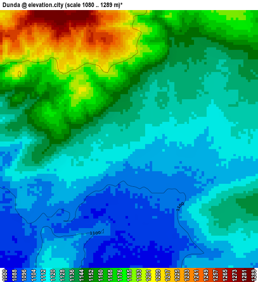
Below is the Elevation map of Dunda, which displays elevation range with different colors. Scale of the first map is from 1080 to 1289 m (3543 to 4229 ft) with average elevation of 1136.8 meters (=3730 ft) [note 1]
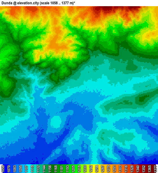
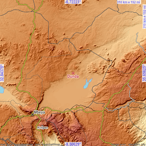
These maps also provides idea of topography and contour of this city, they are displayed at different zoom levels. More info about maps, scale and edge coordinates you can find below images.
| \ | Map #1 | Map #2 | Topo.Map |
| Scale [m] | 1080..1289 m | 1058..1377 m | × |
| Scale [ft] | 3543..4229 ft | 3471..4518 ft | × |
| Average | 1136.8 m = 3730 ft | 1153.9 m = 3786 ft | × |
| Width | 9.67 km = 6 mi | 19.35 km = 12 mi | 309.6 km = 192.4 mi |
| Height | 9.67 km = 6 mi | 19.35 km = 12 mi | 309.6 km = 192.4 mi |
| ↑Max Latitude | -8.073163° | -8.02965° | -6.72223° |
| Latitude at center | -8.11667° | -8.11667° | -8.11667° |
| ↓Min Latitude | -8.160173° | -8.203671° | -9.50629° |
| ← Min Longitude | 34.206055° | 34.162109° | 32.84375° |
| Longitude center | 34.25° | 34.25° | 34.25° |
| →Max Longitude | 34.293945° | 34.337891° | 35.65625° |
Nearby cities:
Cities around Dunda sort by population:
• Mbeya elevation 1697 m
123.8 km,  225°
225°
• Makumbako 1651 m
103.7 km,  141°
141°
• Mafinga 1018 m
131.8 km,  43°
43°
• Rujewa 1078 m
66.5 km,  167°
167°
• Igurusi 1258 m
92.6 km,  208°
208°
• Chimala 1143 m
85.9 km,  196°
196°
• Mtwango 1767 m
116.9 km,  148°
148°
• Ilembula 1425 m
94.5 km,  157°
157°
• Ulenje 1929 m
110.1 km, 214°
• Matamba 2088 m
101.3 km, 197°
• Kandete 1578 m
125.1 km, 203°
• Malangali 1388 m
82.8 km,  127°
127°
Multilingual:
 En español:
Dunda elevación 1124 m.
 En France:
Dunda élévation 1124 m.


Sources and notes:
- [note 1] Map square and city borders are not equal. Map elevation data is calculated only from area inside that square.
- [src 1] Elevation data from geonames database provided with same terms of usage.
- [src 2] The elevation map of Dunda is generated using elevation data from NASA's 3 arcsec (90m) resolution SRTM data.
- [src 3] Base (background) map © OpenStreetMap contributors tiles are generated by Geofabrik and OpenTopoMap.
Copyright & License:
This Dunda Elevation Map is licensed under CC BY-SA. You may reuse any part from this page, if you give a proper credit by linking to this URL:
 More info on terms of use page.