Mugumu elevation
Mugumu (Mara, Serengeti), Tanzania elevation is 1551 meters and Mugumu elevation in feet is 5089 ft above sea level [src 1]. Mugumu is a populated place (feature code) with elevation that is 608 meters (1995 ft) bigger than average city elevation in Tanzania.
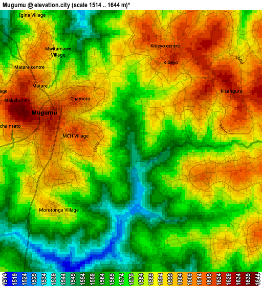
Below is the Elevation map of Mugumu, which displays elevation range with different colors. Scale of the first map is from 1514 to 1644 m (4967 to 5394 ft) with average elevation of 1584.2 meters (=5198 ft) [note 1]
These maps also provides idea of topography and contour of this city, they are displayed at different zoom levels. More info about maps, scale and edge coordinates you can find below images.
| \ | Map #1 | Map #2 | Topo.Map |
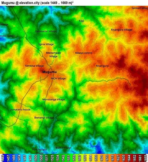
| Scale [m] | 1514..1644 m | 1449..1669 m | × |
| Scale [ft] | 4967..5394 ft | 4754..5476 ft | × |
| Average | 1584.2 m = 5198 ft | 1566.6 m = 5140 ft | × |
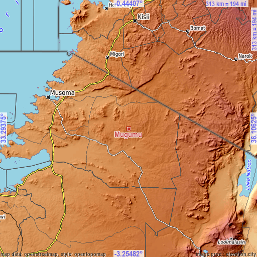
| Width | 9.77 km = 6.1 mi | 19.53 km = 12.1 mi | 312.5 km = 194.2 mi |
| Height | 9.77 km = 6.1 mi | 19.53 km = 12.1 mi | 312.6 km = 194.2 mi |
| ↑Max Latitude | -1.806077° | -1.762153° | -0.44407° |
| Latitude at center | -1.85° | -1.85° | -1.85° |
| ↓Min Latitude | -1.893922° | -1.937843° | -3.25482° |
| ← Min Longitude | 34.656055° | 34.612109° | 33.29375° |
| Longitude center | 34.7° | 34.7° | 34.7° |
| →Max Longitude | 34.743945° | 34.787891° | 36.10625° |
Nearby cities:
Cities around Mugumu sort by population:
• Musoma elevation 1148 m
107.3 km,  291°
291°
• Bunda 1174 m
95.2 km,  256°
256°
• Bariadi 1282 m
132.3 km,  217°
217°
• Tarime 1398 m
66.8 km,  326°
326°
• Sirari 1679 m
70.8 km,  339°
339°
• Maswa 1310 m
122.2 km, 220°
• Nyakabindi 1295 m
118 km, 222°
• Nyamuswa 1386 m
76.1 km,  265°
265°
• Butiama 1500 m
82 km,  276°
276°
• Matonga 1281 m
90.6 km,  229°
229°
• Mugango 1134 m
112.7 km, 279°
• Issenye 1258 m
44 km,  247°
247°
Multilingual:
 En español:
Mugumu elevación 1551 m.
 En France:
Mugumu élévation 1551 m.


Sources and notes:
- [note 1] Map square and city borders are not equal. Map elevation data is calculated only from area inside that square.
- [src 1] Elevation data from geonames database provided with same terms of usage.
- [src 2] The elevation map of Mugumu is generated using elevation data from NASA's 3 arcsec (90m) resolution SRTM data.
- [src 3] Base (background) map © OpenStreetMap contributors tiles are generated by Geofabrik and OpenTopoMap.
Copyright & License:
This Mugumu Elevation Map is licensed under CC BY-SA. You may reuse any part from this page, if you give a proper credit by linking to this URL:
 More info on terms of use page.