Same elevation
Same (Kilimanjaro), Tanzania elevation is 867 meters and Same elevation in feet is 2844 ft above sea level [src 1]. Same is a populated place (feature code) with elevation that is 76 meters (249 ft) smaller than average city elevation in Tanzania.
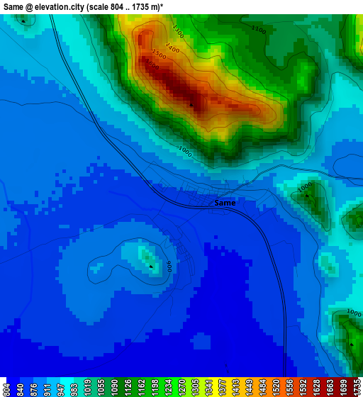
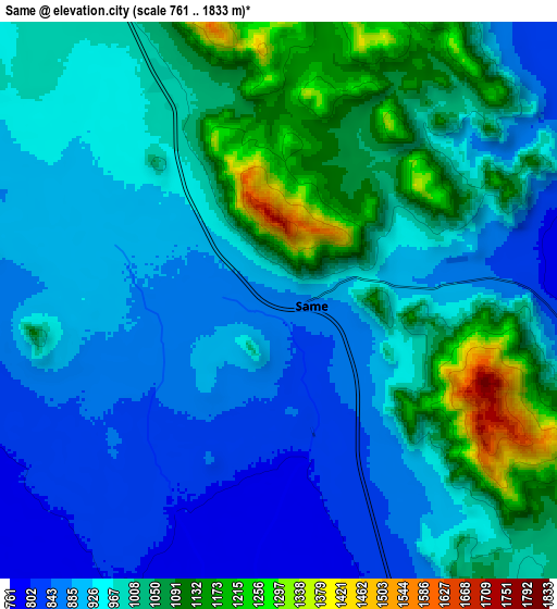
Below is the Elevation map of Same, which displays elevation range with different colors. Scale of the first map is from 804 to 1735 m (2638 to 5692 ft) with average elevation of 972.1 meters (=3189 ft) [note 1]
These maps also provides idea of topography and contour of this city, they are displayed at different zoom levels. More info about maps, scale and edge coordinates you can find below images.
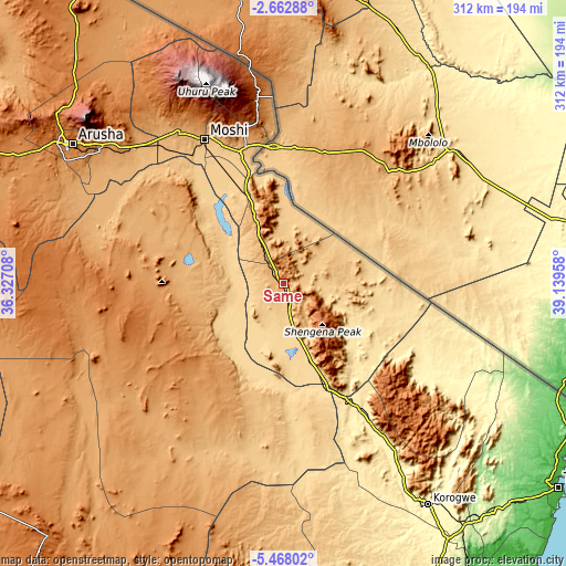
| \ | Map #1 | Map #2 | Topo.Map |
| Scale [m] | 804..1735 m | 761..1833 m | × |
| Scale [ft] | 2638..5692 ft | 2497..6014 ft | × |
| Average | 972.1 m = 3189 ft | 975.2 m = 3199 ft | × |
| Width | 9.75 km = 6.1 mi | 19.5 km = 12.1 mi | 311.9 km = 193.8 mi |
| Height | 9.75 km = 6.1 mi | 19.5 km = 12.1 mi | 311.9 km = 193.8 mi |
| ↑Max Latitude | -4.022834° | -3.978996° | -2.66288° |
| Latitude at center | -4.06667° | -4.06667° | -4.06667° |
| ↓Min Latitude | -4.110503° | -4.154335° | -5.46802° |
| ← Min Longitude | 37.689385° | 37.645439° | 36.32708° |
| Longitude center | 37.73333° | 37.73333° | 37.73333° |
| →Max Longitude | 37.777275° | 37.821221° | 39.13958° |
Nearby cities:
Cities around Same sort by population:
• Moshi elevation 854 m
91.2 km,  330°
330°
• Hedaru 640 m
51.6 km,  159°
159°
• Lembeni 979 m
34.1 km,  337°
337°
• Makuyuni 479 m
84.5 km,  151°
151°
• Ndungu 535 m
48.4 km,  133°
133°
• Naberera 1430 m
90 km,  260°
260°
• Makanya 681 m
35.2 km, 161°
• Mwembe 1009 m
15.9 km, 125°
• Kihurio 531 m
57.8 km,  140°
140°
• Kwakoa 775 m
33.4 km,  356°
356°
• Kisiwani 677 m
25.1 km,  107°
107°
• Kirya 659 m
32.4 km,  301°
301°
Multilingual:
 En español:
Same elevación 867 m.
 En France:
Same élévation 867 m.


Sources and notes:
- [note 1] Map square and city borders are not equal. Map elevation data is calculated only from area inside that square.
- [src 1] Elevation data from geonames database provided with same terms of usage.
- [src 2] The elevation map of Same is generated using elevation data from NASA's 3 arcsec (90m) resolution SRTM data.
- [src 3] Base (background) map © OpenStreetMap contributors tiles are generated by Geofabrik and OpenTopoMap.
Copyright & License:
This Same Elevation Map is licensed under CC BY-SA. You may reuse any part from this page, if you give a proper credit by linking to this URL:
 More info on terms of use page.