Ezinepazarı elevation
Ezinepazarı (Amasya), Turkey elevation is 751 meters and Ezinepazarı elevation in feet is 2464 ft above sea level [src 1]. Ezinepazarı is a seat of a third-order administrative division (feature code) with elevation that is 28 meters (92 ft) bigger than average city elevation in Turkey.
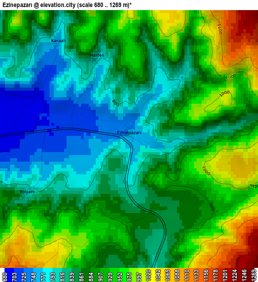
Below is the Elevation map of Ezinepazarı, which displays elevation range with different colors. Scale of the first map is from 680 to 1269 m (2231 to 4163 ft) with average elevation of 884.8 meters (=2903 ft) [note 1]
These maps also provides idea of topography and contour of this city, they are displayed at different zoom levels. More info about maps, scale and edge coordinates you can find below images.
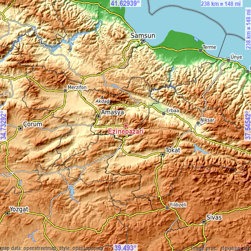
| \ | Map #1 | Topo.Map |
| Scale [m] | 680..1269 m | × |
| Scale [ft] | 2231..4163 ft | × |
| Average | 884.8 m = 2903 ft | × |
| Width | 7.42 km = 4.6 mi | 237.5 km = 147.6 mi |
| Height | 7.42 km = 4.6 mi | 237.5 km = 147.6 mi |
| ↑Max Latitude | 40.603093° | 41.62939° |
| Latitude at center | 40.56972° | 40.56972° |
| ↓Min Latitude | 40.53633° | 39.493° |
| ← Min Longitude | 36.095225° | 34.73292° |
| Longitude center | 36.13917° | 36.13917° |
| →Max Longitude | 36.183115° | 37.54542° |
Nearby cities:
Cities around Ezinepazarı sort by population:
• Turhal elevation 538 m
20.8 km,  193°
193°
• Amasya 402 m
27.5 km,  289°
289°
• Zile 746 m
36.6 km,  215°
215°
• Taşova 241 m
26.2 km,  36°
36°
• Yeşilyurt 574 m
32.3 km,  146°
146°
• Pazar 576 m
34.8 km,  159°
159°
• Dökmetepe 561 m
31.4 km, 155°
• Destek 690 m
31 km,  6°
6°
• Kozlu 928 m
29 km,  81°
81°
• Esençay 569 m
23.1 km,  61°
61°
• Akdağ 441 m
21 km,  319°
319°
• Tekke 357 m
16.8 km,  15°
15°
Multilingual:
 En español:
Ezinepazarı elevación 751 m.
 En France:
Ezinepazarı élévation 751 m.
 Auf Deutsch:
Ezinepazarı höhe über dem Meeresspiegel ist 751 m.

Sources and notes:
- [note 1] Map square and city borders are not equal. Map elevation data is calculated only from area inside that square.
- [src 1] Elevation data from geonames database provided with same terms of usage.
- [src 2] The elevation map of Ezinepazarı is generated using elevation data from NASA's 3 arcsec (90m) resolution SRTM data.
- [src 3] Base (background) map © OpenStreetMap contributors tiles are generated by Geofabrik and OpenTopoMap.
Copyright & License:
This Ezinepazarı Elevation Map is licensed under CC BY-SA. You may reuse any part from this page, if you give a proper credit by linking to this URL:
 More info on terms of use page.