Biga elevation
Biga (Canakkale), Turkey elevation is 37 meters and Biga elevation in feet is 121 ft above sea level [src 1]. Biga is a seat of a second-order administrative division (feature code) with elevation that is 686 meters (2251 ft) smaller than average city elevation in Turkey.
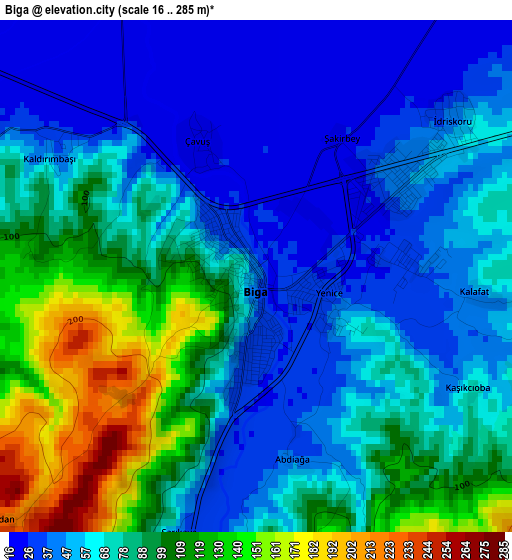
Below is the Elevation map of Biga, which displays elevation range with different colors. Scale of the first map is from 16 to 285 m (52 to 935 ft) with average elevation of 73.8 meters (=242 ft) [note 1]
These maps also provides idea of topography and contour of this city, they are displayed at different zoom levels. More info about maps, scale and edge coordinates you can find below images.
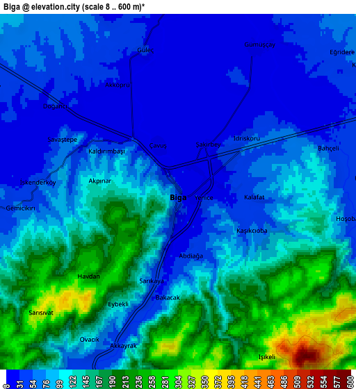
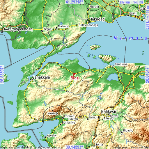
| \ | Map #1 | Map #2 | Topo.Map |
| Scale [m] | 16..285 m | 8..600 m | × |
| Scale [ft] | 52..935 ft | 26..1969 ft | × |
| Average | 73.8 m = 242 ft | 105.9 m = 347 ft | × |
| Width | 7.46 km = 4.6 mi | 14.92 km = 9.3 mi | 238.8 km = 148.4 mi |
| Height | 7.46 km = 4.6 mi | 14.92 km = 9.3 mi | 238.7 km = 148.3 mi |
| ↑Max Latitude | 40.261603° | 40.295129° | 41.29318° |
| Latitude at center | 40.22806° | 40.22806° | 40.22806° |
| ↓Min Latitude | 40.1945° | 40.160924° | 39.14593° |
| ← Min Longitude | 27.198275° | 27.154329° | 25.83597° |
| Longitude center | 27.24222° | 27.24222° | 27.24222° |
| →Max Longitude | 27.286165° | 27.330111° | 28.64847° |
Nearby cities:
Cities around Biga sort by population:
• Gönen elevation 40 m
37.6 km,  111°
111°
• Çan 115 m
27 km,  216°
216°
• Etili 130 m
39.9 km,  227°
227°
• Yenice 274 m
33.1 km,  177°
177°
• Sarıköy 36 m
30.1 km,  94°
94°
• Beyçayırı 462 m
27.1 km,  276°
276°
• Karabiga 9 m
20.2 km,  14°
14°
• Balıklıçeşme 68 m
16.4 km,  303°
303°
• Sinekçi 66 m
14.7 km,  71°
71°
• Bakacak 42 m
13.7 km,  259°
259°
• Gündoğdu 46 m
13.3 km,  287°
287°
• Dimetoka 19 m
6.9 km,  29°
29°
Multilingual:
 En español:
Biga elevación 37 m.
 En France:
Biga élévation 37 m.


Sources and notes:
- [note 1] Map square and city borders are not equal. Map elevation data is calculated only from area inside that square.
- [src 1] Elevation data from geonames database provided with same terms of usage.
- [src 2] The elevation map of Biga is generated using elevation data from NASA's 3 arcsec (90m) resolution SRTM data.
- [src 3] Base (background) map © OpenStreetMap contributors tiles are generated by Geofabrik and OpenTopoMap.
Copyright & License:
This Biga Elevation Map is licensed under CC BY-SA. You may reuse any part from this page, if you give a proper credit by linking to this URL:
 More info on terms of use page.