Çağlayan elevation
Çağlayan (Trabzon), Turkey elevation is 150 meters and Çağlayan elevation in feet is 492 ft above sea level [src 1]. Çağlayan is a seat of a third-order administrative division (feature code) with elevation that is 573 meters (1880 ft) smaller than average city elevation in Turkey.
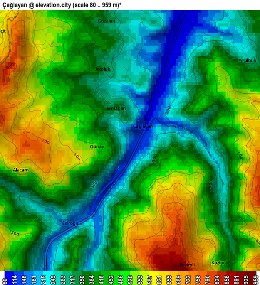
Below is the Elevation map of Çağlayan, which displays elevation range with different colors. Scale of the first map is from 80 to 959 m (262 to 3146 ft) with average elevation of 427.6 meters (=1403 ft) [note 1]
These maps also provides idea of topography and contour of this city, they are displayed at different zoom levels. More info about maps, scale and edge coordinates you can find below images.
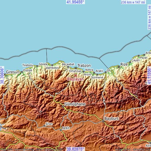
| \ | Map #1 | Topo.Map |
| Scale [m] | 80..959 m | × |
| Scale [ft] | 262..3146 ft | × |
| Average | 427.6 m = 1403 ft | × |
| Width | 7.39 km = 4.6 mi | 236.4 km = 146.9 mi |
| Height | 7.39 km = 4.6 mi | 236.4 km = 146.9 mi |
| ↑Max Latitude | 40.933398° | 41.95455° |
| Latitude at center | 40.90019° | 40.90019° |
| ↓Min Latitude | 40.866966° | 39.82875° |
| ← Min Longitude | 39.668365° | 38.30606° |
| Longitude center | 39.71231° | 39.71231° |
| →Max Longitude | 39.756255° | 41.11856° |
Nearby cities:
Cities around Çağlayan sort by population:
• Trabzon elevation 39 m
11.7 km,  6°
6°
• Akçaabat 21 m
17.9 km,  318°
318°
• Araklı 8 m
29.4 km,  81°
81°
• Yomra 79 m
13.4 km,  63°
63°
• Arsin 16 m
18.9 km,  72°
72°
• Maçka 401 m
13.5 km,  222°
222°
• Düzköy 713 m
25.1 km,  263°
263°
• Çarşıbaşı 12 m
34.3 km,  306°
306°
• Küçükdere 644 m
30.6 km,  109°
109°
• Dağbaşı 587 m
25.5 km,  138°
138°
• Derecik 332 m
11.2 km,  297°
297°
• Esiroğlu 240 m
3.6 km,  214°
214°
Multilingual:
 En español:
Çağlayan elevación 150 m.
 En France:
Çağlayan élévation 150 m.
 Auf Deutsch:
Çağlayan höhe über dem Meeresspiegel ist 150 m.

Sources and notes:
- [note 1] Map square and city borders are not equal. Map elevation data is calculated only from area inside that square.
- [src 1] Elevation data from geonames database provided with same terms of usage.
- [src 2] The elevation map of Çağlayan is generated using elevation data from NASA's 3 arcsec (90m) resolution SRTM data.
- [src 3] Base (background) map © OpenStreetMap contributors tiles are generated by Geofabrik and OpenTopoMap.
Copyright & License:
This Çağlayan Elevation Map is licensed under CC BY-SA. You may reuse any part from this page, if you give a proper credit by linking to this URL:
 More info on terms of use page.