Çaycuma elevation
Çaycuma (Zonguldak), Turkey elevation is 43 meters and Çaycuma elevation in feet is 141 ft above sea level [src 1]. Çaycuma is a seat of a second-order administrative division (feature code) with elevation that is 680 meters (2231 ft) smaller than average city elevation in Turkey.
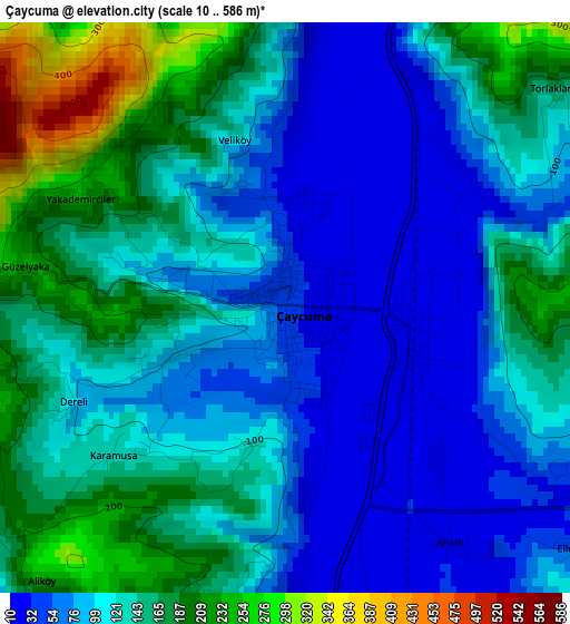
Below is the Elevation map of Çaycuma, which displays elevation range with different colors. Scale of the first map is from 10 to 586 m (33 to 1923 ft) with average elevation of 122.5 meters (=402 ft) [note 1]
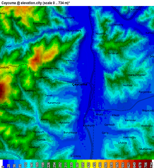
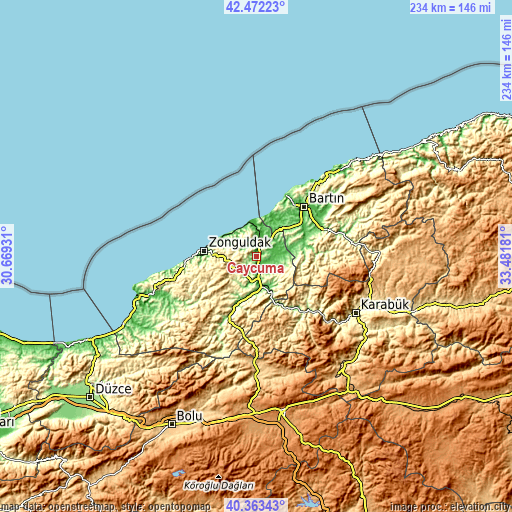
These maps also provides idea of topography and contour of this city, they are displayed at different zoom levels. More info about maps, scale and edge coordinates you can find below images.
| \ | Map #1 | Map #2 | Topo.Map |
| Scale [m] | 10..586 m | 0..734 m | × |
| Scale [ft] | 33..1923 ft | 0..2408 ft | × |
| Average | 122.5 m = 402 ft | 154.3 m = 506 ft | × |
| Width | 7.33 km = 4.6 mi | 14.66 km = 9.1 mi | 234.5 km = 145.7 mi |
| Height | 7.33 km = 4.6 mi | 14.66 km = 9.1 mi | 234.5 km = 145.7 mi |
| ↑Max Latitude | 41.459332° | 41.492258° | 42.47223° |
| Latitude at center | 41.42639° | 41.42639° | 41.42639° |
| ↓Min Latitude | 41.393431° | 41.360456° | 40.36343° |
| ← Min Longitude | 32.031615° | 31.987669° | 30.66931° |
| Longitude center | 32.07556° | 32.07556° | 32.07556° |
| →Max Longitude | 32.119505° | 32.163451° | 33.48181° |
Nearby cities:
Cities around Çaycuma sort by population:
• Zonguldak elevation 24 m
23.7 km,  276°
276°
• Bartın 28 m
31.9 km,  43°
43°
• Devrek 95 m
25.1 km,  203°
203°
• Gökçebey 64 m
14.5 km,  157°
157°
• Kumluca 216 m
32.8 km,  85°
85°
• Kozlu 101 m
27.5 km,  271°
271°
• Kozcağız 118 m
22.4 km,  73°
73°
• Kilimli 11 m
21 km,  290°
290°
• Filyos 31 m
14.8 km,  343°
343°
• Beycuma 185 m
14.1 km,  219°
219°
• Saltukova 13 m
10.6 km,  9°
9°
• Perşembe 73 m
7.1 km,  96°
96°
Multilingual:
 En español:
Çaycuma elevación 43 m.
 En France:
Çaycuma élévation 43 m.


Sources and notes:
- [note 1] Map square and city borders are not equal. Map elevation data is calculated only from area inside that square.
- [src 1] Elevation data from geonames database provided with same terms of usage.
- [src 2] The elevation map of Çaycuma is generated using elevation data from NASA's 3 arcsec (90m) resolution SRTM data.
- [src 3] Base (background) map © OpenStreetMap contributors tiles are generated by Geofabrik and OpenTopoMap.
Copyright & License:
This Çaycuma Elevation Map is licensed under CC BY-SA. You may reuse any part from this page, if you give a proper credit by linking to this URL:
 More info on terms of use page.