Durağan elevation
Durağan (Sinop), Turkey elevation is 218 meters and Durağan elevation in feet is 715 ft above sea level [src 1]. Durağan is a seat of a second-order administrative division (feature code) with elevation that is 505 meters (1657 ft) smaller than average city elevation in Turkey.
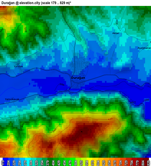
Below is the Elevation map of Durağan, which displays elevation range with different colors. Scale of the first map is from 179 to 829 m (587 to 2720 ft) with average elevation of 367.9 meters (=1207 ft) [note 1]
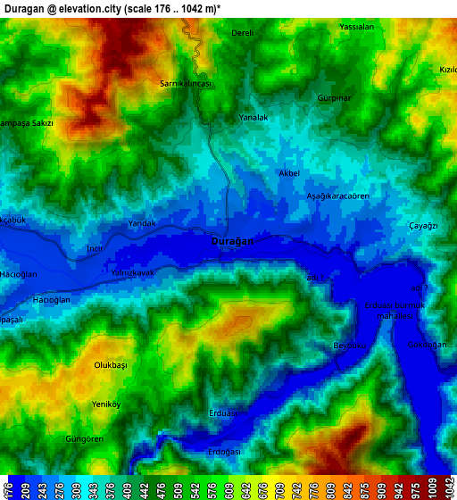
These maps also provides idea of topography and contour of this city, they are displayed at different zoom levels. More info about maps, scale and edge coordinates you can find below images.
| \ | Map #1 | Map #2 | Topo.Map |
| Scale [m] | 179..829 m | 176..1042 m | × |
| Scale [ft] | 587..2720 ft | 577..3419 ft | × |
| Average | 367.9 m = 1207 ft | 452.2 m = 1484 ft | × |
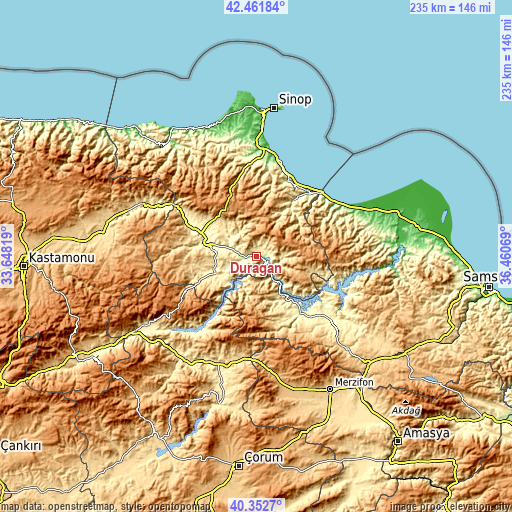
| Width | 7.33 km = 4.6 mi | 14.66 km = 9.1 mi | 234.5 km = 145.7 mi |
| Height | 7.33 km = 4.6 mi | 14.66 km = 9.1 mi | 234.5 km = 145.7 mi |
| ↑Max Latitude | 41.448777° | 41.481708° | 42.46184° |
| Latitude at center | 41.41583° | 41.41583° | 41.41583° |
| ↓Min Latitude | 41.382866° | 41.349885° | 40.3527° |
| ← Min Longitude | 35.010495° | 34.966549° | 33.64819° |
| Longitude center | 35.05444° | 35.05444° | 35.05444° |
| →Max Longitude | 35.098385° | 35.142331° | 36.46069° |
Nearby cities:
Cities around Durağan sort by population:
• Boyabat elevation 314 m
24.7 km,  283°
283°
• Vezirköprü 335 m
45.1 km,  132°
132°
• Gerze 32 m
44.8 km,  15°
15°
• Yakakent 13 m
46.3 km,  58°
58°
• Alaçam 45 m
49.9 km,  65°
65°
• Kabalı 81 m
48.5 km,  0°
0°
• Kâmil 424 m
42.4 km,  215°
215°
• Beşpınar 675 m
33.7 km,  156°
156°
• Dikmen 178 m
31.5 km,  34°
34°
• Mezraa 730 m
24.8 km,  167°
167°
• Saraydüzü 424 m
19.8 km,  240°
240°
• Çerçiler 818 m
15.4 km,  98°
98°
Multilingual:
 En español:
Durağan elevación 218 m.
 En France:
Durağan élévation 218 m.


Sources and notes:
- [note 1] Map square and city borders are not equal. Map elevation data is calculated only from area inside that square.
- [src 1] Elevation data from geonames database provided with same terms of usage.
- [src 2] The elevation map of Durağan is generated using elevation data from NASA's 3 arcsec (90m) resolution SRTM data.
- [src 3] Base (background) map © OpenStreetMap contributors tiles are generated by Geofabrik and OpenTopoMap.
Copyright & License:
This Durağan Elevation Map is licensed under CC BY-SA. You may reuse any part from this page, if you give a proper credit by linking to this URL:
 More info on terms of use page.