Gözyeri elevation
Gözyeri (Karabük), Turkey elevation is 1250 meters and Gözyeri elevation in feet is 4101 ft above sea level [src 1]. Gözyeri is a populated place (feature code) with elevation that is 527 meters (1729 ft) bigger than average city elevation in Turkey.
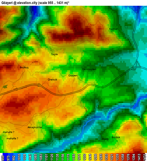
Below is the Elevation map of Gözyeri, which displays elevation range with different colors. Scale of the first map is from 955 to 1431 m (3133 to 4695 ft) with average elevation of 1197.6 meters (=3929 ft) [note 1]
These maps also provides idea of topography and contour of this city, they are displayed at different zoom levels. More info about maps, scale and edge coordinates you can find below images.
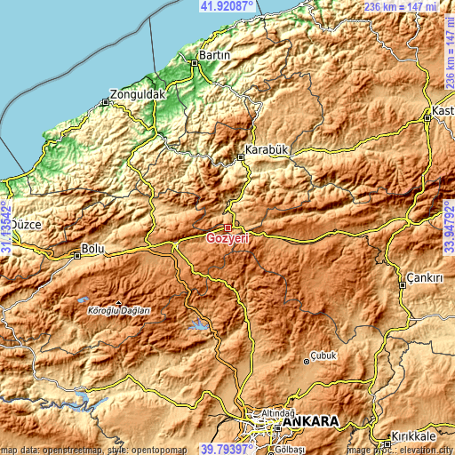
| \ | Map #1 | Map #2 | Topo.Map |
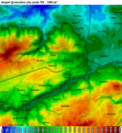
| Scale [m] | 955..1431 m | 759..1690 m | × |
| Scale [ft] | 3133..4695 ft | 2490..5545 ft | × |
| Average | 1197.6 m = 3929 ft | 1177.8 m = 3864 ft | × |
| Width | 7.39 km = 4.6 mi | 14.78 km = 9.2 mi | 236.5 km = 147 mi |
| Height | 7.39 km = 4.6 mi | 14.78 km = 9.2 mi | 236.5 km = 147 mi |
| ↑Max Latitude | 40.899185° | 40.932393° | 41.92087° |
| Latitude at center | 40.86596° | 40.86596° | 40.86596° |
| ↓Min Latitude | 40.832718° | 40.79946° | 39.79397° |
| ← Min Longitude | 32.497725° | 32.453779° | 31.13542° |
| Longitude center | 32.54167° | 32.54167° | 32.54167° |
| →Max Longitude | 32.585615° | 32.629561° | 33.94792° |
Nearby cities:
Cities around Gözyeri sort by population:
• Karabük elevation 316 m
38.4 km,  10°
10°
• Gerede 1325 m
29.9 km,  255°
255°
• Çerkeş 1133 m
30.2 km,  101°
101°
• Çamlıdere 1254 m
42.2 km,  187°
187°
• Yeniçağa 1005 m
44 km, 256°
• Dörtdivan 1166 m
43.4 km,  248°
248°
• Yenice 137 m
41.1 km,  334°
334°
• Mengen 618 m
39.9 km,  281°
281°
• Ovacık 1118 m
39.5 km,  53°
53°
• Güvem 1095 m
32.2 km,  161°
161°
• Pazarköy 714 m
31.1 km, 282°
• Eskipazar 742 m
8.6 km,  353°
353°
Multilingual:
 En español:
Gözyeri elevación 1250 m.
 En France:
Gözyeri élévation 1250 m.
 Auf Deutsch:
Gözyeri höhe über dem Meeresspiegel ist 1250 m.

Sources and notes:
- [note 1] Map square and city borders are not equal. Map elevation data is calculated only from area inside that square.
- [src 1] Elevation data from geonames database provided with same terms of usage.
- [src 2] The elevation map of Gözyeri is generated using elevation data from NASA's 3 arcsec (90m) resolution SRTM data.
- [src 3] Base (background) map © OpenStreetMap contributors tiles are generated by Geofabrik and OpenTopoMap.
Copyright & License:
This Gözyeri Elevation Map is licensed under CC BY-SA. You may reuse any part from this page, if you give a proper credit by linking to this URL:
 More info on terms of use page.