Gökçesu elevation
Gökçesu (Bolu), Turkey elevation is 528 meters and Gökçesu elevation in feet is 1732 ft above sea level [src 1]. Gökçesu is a seat of a third-order administrative division (feature code) with elevation that is 195 meters (640 ft) smaller than average city elevation in Turkey.
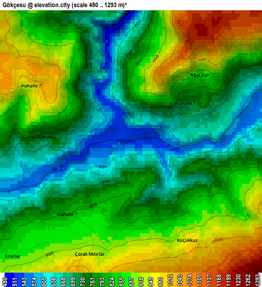
Below is the Elevation map of Gökçesu, which displays elevation range with different colors. Scale of the first map is from 480 to 1293 m (1575 to 4242 ft) with average elevation of 809.2 meters (=2655 ft) [note 1]
These maps also provides idea of topography and contour of this city, they are displayed at different zoom levels. More info about maps, scale and edge coordinates you can find below images.
| \ | Map #1 | Topo.Map |
| Scale [m] | 480..1293 m | × |
| Scale [ft] | 1575..4242 ft | × |
| Average | 809.2 m = 2655 ft | × |
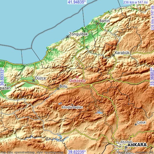
| Width | 7.39 km = 4.6 mi | 236.4 km = 146.9 mi |
| Height | 7.39 km = 4.6 mi | 236.4 km = 146.9 mi |
| ↑Max Latitude | 40.927101° | 41.94835° |
| Latitude at center | 40.89389° | 40.89389° |
| ↓Min Latitude | 40.860662° | 39.82235° |
| ← Min Longitude | 31.915625° | 30.55332° |
| Longitude center | 31.95957° | 31.95957° |
| →Max Longitude | 32.003515° | 33.36582° |
Nearby cities:
Cities around Gökçesu sort by population:
• Bolu elevation 733 m
34.5 km,  239°
239°
• Gerede 1325 m
22.5 km,  117°
117°
• Devrek 95 m
36.2 km,  359°
359°
• Yeniçağa 1005 m
15 km,  155°
155°
• Dörtdivan 1166 m
21.2 km, 155°
• Beycuma 185 m
48.3 km,  0°
0°
• Yenice 137 m
46.1 km,  42°
42°
• Yığılca 330 m
44 km,  279°
279°
• Ormanlı 190 m
41.8 km,  316°
316°
• Eğerci 262 m
25.8 km,  332°
332°
• Pazarköy 714 m
18.9 km,  79°
79°
• Mengen 618 m
11 km,  63°
63°
Multilingual:
 En español:
Gökçesu elevación 528 m.
 En France:
Gökçesu élévation 528 m.


Sources and notes:
- [note 1] Map square and city borders are not equal. Map elevation data is calculated only from area inside that square.
- [src 1] Elevation data from geonames database provided with same terms of usage.
- [src 2] The elevation map of Gökçesu is generated using elevation data from NASA's 3 arcsec (90m) resolution SRTM data.
- [src 3] Base (background) map © OpenStreetMap contributors tiles are generated by Geofabrik and OpenTopoMap.
Copyright & License:
This Gökçesu Elevation Map is licensed under CC BY-SA. You may reuse any part from this page, if you give a proper credit by linking to this URL:
 More info on terms of use page.