İğdir elevation
İğdir (Kastamonu), Turkey elevation is 551 meters and İğdir elevation in feet is 1808 ft above sea level [src 1]. İğdir is a seat of a third-order administrative division (feature code) with elevation that is 172 meters (564 ft) smaller than average city elevation in Turkey.
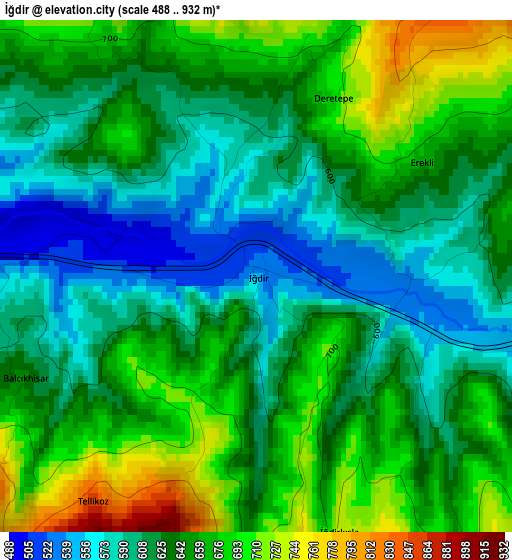
Below is the Elevation map of İğdir, which displays elevation range with different colors. Scale of the first map is from 488 to 932 m (1601 to 3058 ft) with average elevation of 639 meters (=2096 ft) [note 1]
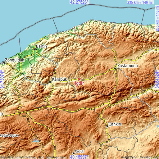
These maps also provides idea of topography and contour of this city, they are displayed at different zoom levels. More info about maps, scale and edge coordinates you can find below images.
| \ | Map #1 | Topo.Map |
| Scale [m] | 488..932 m | × |
| Scale [ft] | 1601..3058 ft | × |
| Average | 639 m = 2096 ft | × |
| Width | 7.35 km = 4.6 mi | 235.2 km = 146.1 mi |
| Height | 7.35 km = 4.6 mi | 235.2 km = 146.1 mi |
| ↑Max Latitude | 41.259214° | 42.27526° |
| Latitude at center | 41.22617° | 41.22617° |
| ↓Min Latitude | 41.19311° | 40.15997° |
| ← Min Longitude | 33.093045° | 31.73074° |
| Longitude center | 33.13699° | 33.13699° |
| →Max Longitude | 33.180935° | 34.54324° |
Nearby cities:
Cities around İğdir sort by population:
• Karabük elevation 316 m
42.7 km,  266°
266°
• Safranbolu 494 m
37.1 km, 274°
• Araç 675 m
16 km,  83°
83°
• Daday 869 m
39.3 km,  44°
44°
• Eflani 908 m
26.5 km,  325°
325°
• Bayramören 861 m
31.9 km,  170°
170°
• İhsangazi 868 m
35 km,  93°
93°
• Pınarbaşı 672 m
42.1 km,  357°
357°
• Ovacuma 361 m
40.4 km,  307°
307°
• Akkaya 783 m
29.1 km, 91°
• Boyalı 676 m
26.2 km,  147°
147°
• Ovacık 1118 m
24.6 km,  227°
227°
Multilingual:
 En español:
İğdir elevación 551 m.
 En France:
İğdir élévation 551 m.


Sources and notes:
- [note 1] Map square and city borders are not equal. Map elevation data is calculated only from area inside that square.
- [src 1] Elevation data from geonames database provided with same terms of usage.
- [src 2] The elevation map of İğdir is generated using elevation data from NASA's 3 arcsec (90m) resolution SRTM data.
- [src 3] Base (background) map © OpenStreetMap contributors tiles are generated by Geofabrik and OpenTopoMap.
Copyright & License:
This İğdir Elevation Map is licensed under CC BY-SA. You may reuse any part from this page, if you give a proper credit by linking to this URL:
 More info on terms of use page.