Of elevation
Of (Trabzon), Turkey elevation is 8 meters and Of elevation in feet is 26 ft above sea level [src 1]. Of is a seat of a second-order administrative division (feature code) with elevation that is 715 meters (2346 ft) smaller than average city elevation in Turkey.
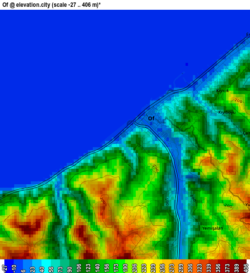
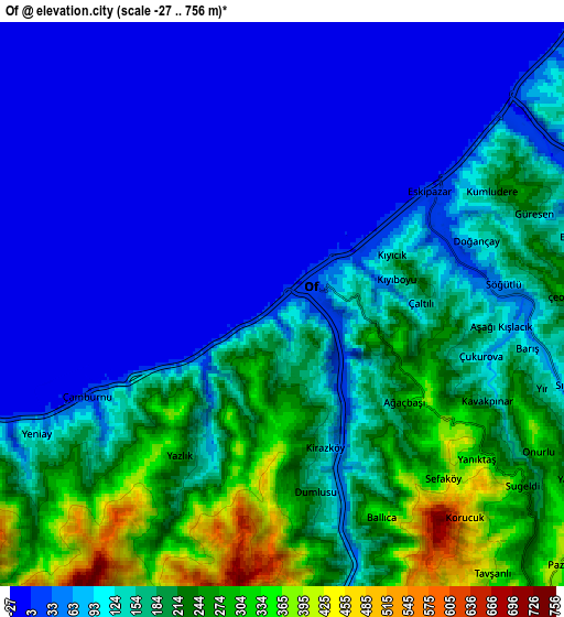
Below is the Elevation map of Of, which displays elevation range with different colors. Scale of the first map is from -27 to 406 m (-89 to 1332 ft) with average elevation of 86 meters (=282 ft) [note 1]
These maps also provides idea of topography and contour of this city, they are displayed at different zoom levels. More info about maps, scale and edge coordinates you can find below images.
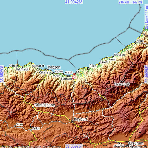
| \ | Map #1 | Map #2 | Topo.Map |
| Scale [m] | -27..406 m | -27..756 m | × |
| Scale [ft] | -89..1332 ft | -89..2480 ft | × |
| Average | 86 m = 282 ft | 133.2 m = 437 ft | × |
| Width | 7.38 km = 4.6 mi | 14.76 km = 9.2 mi | 236.2 km = 146.8 mi |
| Height | 7.38 km = 4.6 mi | 14.76 km = 9.2 mi | 236.2 km = 146.8 mi |
| ↑Max Latitude | 40.973738° | 41.006908° | 41.99426° |
| Latitude at center | 40.94055° | 40.94055° | 40.94055° |
| ↓Min Latitude | 40.907346° | 40.874125° | 39.86976° |
| ← Min Longitude | 40.215235° | 40.171289° | 38.85293° |
| Longitude center | 40.25918° | 40.25918° | 40.25918° |
| →Max Longitude | 40.303125° | 40.347071° | 41.66543° |
Nearby cities:
Cities around Of sort by population:
• Rize elevation 63 m
23.8 km,  67°
67°
• Araklı 8 m
16.9 km,  269°
269°
• Sürmene 81 m
11.7 km,  250°
250°
• Çaykara 601 m
22.1 km,  185°
185°
• Kalkandere 277 m
15.1 km,  98°
98°
• Hayrat 229 m
10.8 km,  124°
124°
• Dernekpazarı 229 m
16.1 km,  184°
184°
• Köprübaşı 469 m
19.2 km,  219°
219°
• İyidere 13 m
11.7 km,  47°
47°
• Küçükdere 644 m
22.7 km,  229°
229°
• Güneyce 566 m
22.2 km,  126°
126°
• Derepazarı 10 m
16.6 km,  56°
56°


Sources and notes:
- [note 1] Map square and city borders are not equal. Map elevation data is calculated only from area inside that square.
- [src 1] Elevation data from geonames database provided with same terms of usage.
- [src 2] The elevation map of Of is generated using elevation data from NASA's 3 arcsec (90m) resolution SRTM data.
- [src 3] Base (background) map © OpenStreetMap contributors tiles are generated by Geofabrik and OpenTopoMap.
Copyright & License:
This Of Elevation Map is licensed under CC BY-SA. You may reuse any part from this page, if you give a proper credit by linking to this URL:
 More info on terms of use page.