Orta elevation
Orta (Çankırı), Turkey elevation is 1257 meters and Orta elevation in feet is 4124 ft above sea level [src 1]. Orta is a seat of a second-order administrative division (feature code) with elevation that is 534 meters (1752 ft) bigger than average city elevation in Turkey.
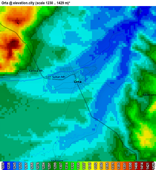
Below is the Elevation map of Orta, which displays elevation range with different colors. Scale of the first map is from 1230 to 1429 m (4035 to 4688 ft) with average elevation of 1279.3 meters (=4197 ft) [note 1]
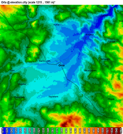
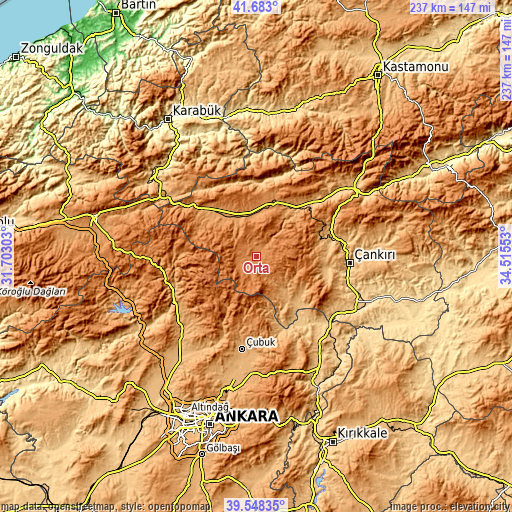
These maps also provides idea of topography and contour of this city, they are displayed at different zoom levels. More info about maps, scale and edge coordinates you can find below images.
| \ | Map #1 | Map #2 | Topo.Map |
| Scale [m] | 1230..1429 m | 1215..1561 m | × |
| Scale [ft] | 4035..4688 ft | 3986..5121 ft | × |
| Average | 1279.3 m = 4197 ft | 1324.4 m = 4345 ft | × |
| Width | 7.42 km = 4.6 mi | 14.83 km = 9.2 mi | 237.4 km = 147.5 mi |
| Height | 7.42 km = 4.6 mi | 14.83 km = 9.2 mi | 237.3 km = 147.5 mi |
| ↑Max Latitude | 40.657546° | 40.690875° | 41.683° |
| Latitude at center | 40.6242° | 40.6242° | 40.6242° |
| ↓Min Latitude | 40.590837° | 40.557458° | 39.54835° |
| ← Min Longitude | 33.065335° | 33.021389° | 31.70303° |
| Longitude center | 33.10928° | 33.10928° | 33.10928° |
| →Max Longitude | 33.153225° | 33.197171° | 34.51553° |
Nearby cities:
Cities around Orta sort by population:
• Khanjarah elevation 727 m
42.8 km,  93°
93°
• Çubuk 999 m
43.4 km,  188°
188°
• Kızılcahamam 980 m
42.4 km,  246°
246°
• Çerkeş 1133 m
27.7 km,  318°
318°
• Kurşunlu 1131 m
27.3 km,  27°
27°
• Şabanözü 1032 m
21.6 km,  136°
136°
• Korgun 907 m
36.6 km,  70°
70°
• Eldivan 949 m
34.5 km,  107°
107°
• Atkaracalar 1247 m
21.5 km,  352°
352°
• Bayramören 861 m
36.3 km,  12°
12°
• Belören 935 m
41.9 km,  50°
50°
• Güvem 1095 m
38 km,  264°
264°
Multilingual:
 En español:
Orta elevación 1257 m.
 En France:
Orta élévation 1257 m.


Sources and notes:
- [note 1] Map square and city borders are not equal. Map elevation data is calculated only from area inside that square.
- [src 1] Elevation data from geonames database provided with same terms of usage.
- [src 2] The elevation map of Orta is generated using elevation data from NASA's 3 arcsec (90m) resolution SRTM data.
- [src 3] Base (background) map © OpenStreetMap contributors tiles are generated by Geofabrik and OpenTopoMap.
Copyright & License:
This Orta Elevation Map is licensed under CC BY-SA. You may reuse any part from this page, if you give a proper credit by linking to this URL:
 More info on terms of use page.