Seben elevation
Seben (Bolu), Turkey elevation is 767 meters and Seben elevation in feet is 2516 ft above sea level [src 1]. Seben is a seat of a second-order administrative division (feature code) with elevation that is 44 meters (144 ft) bigger than average city elevation in Turkey.
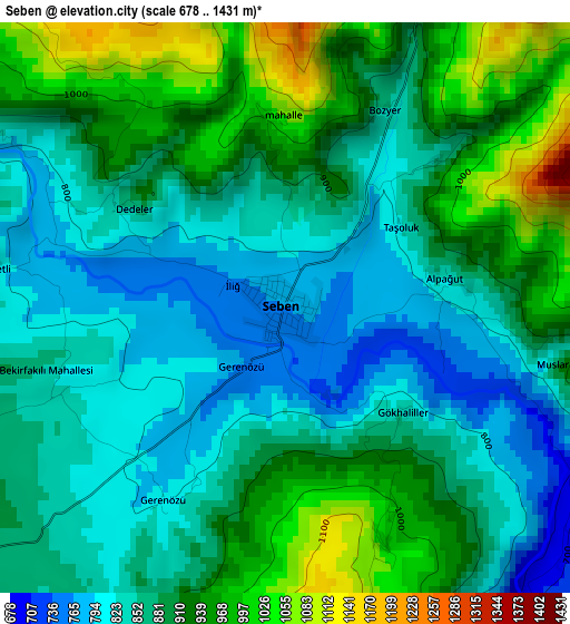
Below is the Elevation map of Seben, which displays elevation range with different colors. Scale of the first map is from 678 to 1431 m (2224 to 4695 ft) with average elevation of 887.9 meters (=2913 ft) [note 1]
These maps also provides idea of topography and contour of this city, they are displayed at different zoom levels. More info about maps, scale and edge coordinates you can find below images.
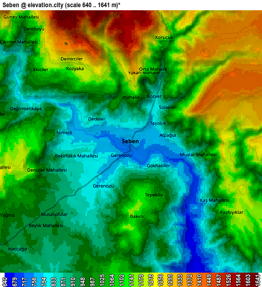
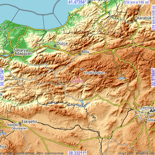
| \ | Map #1 | Map #2 | Topo.Map |
| Scale [m] | 678..1431 m | 640..1641 m | × |
| Scale [ft] | 2224..4695 ft | 2100..5384 ft | × |
| Average | 887.9 m = 2913 ft | 1040.6 m = 3414 ft | × |
| Width | 7.44 km = 4.6 mi | 14.88 km = 9.2 mi | 238.1 km = 147.9 mi |
| Height | 7.44 km = 4.6 mi | 14.88 km = 9.2 mi | 238.1 km = 147.9 mi |
| ↑Max Latitude | 40.444792° | 40.478228° | 41.47354° |
| Latitude at center | 40.41134° | 40.41134° | 40.41134° |
| ↓Min Latitude | 40.377871° | 40.344386° | 39.33211° |
| ← Min Longitude | 31.529645° | 31.485699° | 30.16734° |
| Longitude center | 31.57359° | 31.57359° | 31.57359° |
| →Max Longitude | 31.617535° | 31.661481° | 32.97984° |
Nearby cities:
Cities around Seben sort by population:
• Bolu elevation 733 m
36.2 km,  4°
4°
• Beypazarı 681 m
40 km,  132°
132°
• Nallıhan 630 m
31.3 km,  216°
216°
• Yeniçağa 1005 m
55.8 km,  44°
44°
• Mudurnu 834 m
31.7 km,  282°
282°
• Dörtdivan 1166 m
53.8 km,  50°
50°
• Kıbrıscık 1126 m
23.6 km,  90°
90°
• Uruş 827 m
51.1 km,  110°
110°
• Gelegra 895 m
49.3 km,  153°
153°
• Kaynaşlı 362 m
45.1 km,  331°
331°
• Karaşar 1282 m
36.3 km, 105°
• Çayırhan 493 m
35.8 km,  166°
166°
Multilingual:
 En español:
Seben elevación 767 m.
 En France:
Seben élévation 767 m.


Sources and notes:
- [note 1] Map square and city borders are not equal. Map elevation data is calculated only from area inside that square.
- [src 1] Elevation data from geonames database provided with same terms of usage.
- [src 2] The elevation map of Seben is generated using elevation data from NASA's 3 arcsec (90m) resolution SRTM data.
- [src 3] Base (background) map © OpenStreetMap contributors tiles are generated by Geofabrik and OpenTopoMap.
Copyright & License:
This Seben Elevation Map is licensed under CC BY-SA. You may reuse any part from this page, if you give a proper credit by linking to this URL:
 More info on terms of use page.