Selim elevation
Selim (Kars), Turkey elevation is 1853 meters and Selim elevation in feet is 6079 ft above sea level [src 1]. Selim is a seat of a second-order administrative division (feature code) with elevation that is 1130 meters (3707 ft) bigger than average city elevation in Turkey.
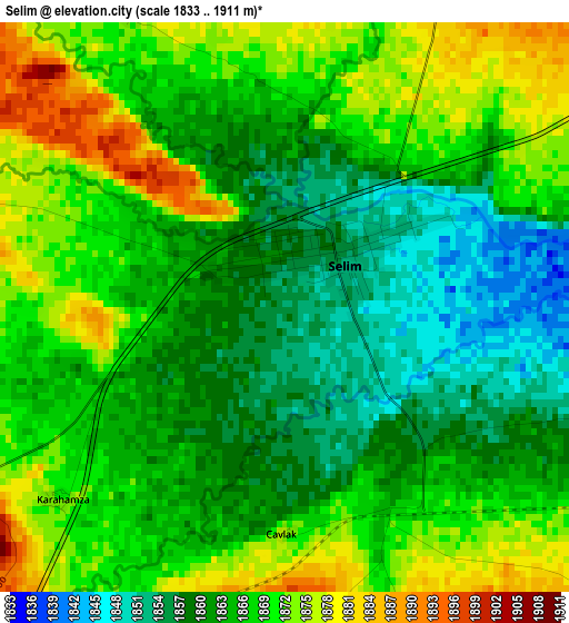
Below is the Elevation map of Selim, which displays elevation range with different colors. Scale of the first map is from 1833 to 1911 m (6014 to 6270 ft) with average elevation of 1865.5 meters (=6120 ft) [note 1]
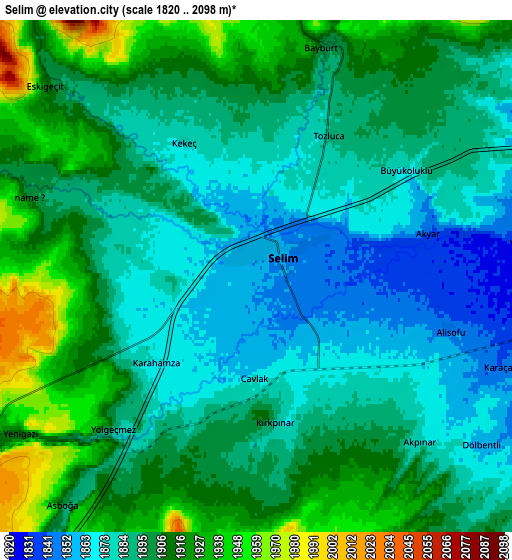
These maps also provides idea of topography and contour of this city, they are displayed at different zoom levels. More info about maps, scale and edge coordinates you can find below images.
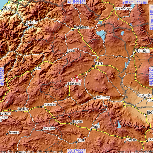
| \ | Map #1 | Map #2 | Topo.Map |
| Scale [m] | 1833..1911 m | 1820..2098 m | × |
| Scale [ft] | 6014..6270 ft | 5971..6883 ft | × |
| Average | 1865.5 m = 6120 ft | 1896.7 m = 6223 ft | × |
| Width | 7.44 km = 4.6 mi | 14.87 km = 9.2 mi | 237.9 km = 147.8 mi |
| Height | 7.44 km = 4.6 mi | 14.87 km = 9.2 mi | 237.9 km = 147.8 mi |
| ↑Max Latitude | 40.491149° | 40.524561° | 41.51918° |
| Latitude at center | 40.45772° | 40.45772° | 40.45772° |
| ↓Min Latitude | 40.424274° | 40.390812° | 39.37922° |
| ← Min Longitude | 42.738925° | 42.694979° | 41.37662° |
| Longitude center | 42.78287° | 42.78287° | 42.78287° |
| →Max Longitude | 42.826815° | 42.870761° | 44.18912° |
Nearby cities:
Cities around Selim sort by population:
• Kars elevation 1767 m
30 km,  58°
58°
• Kağızman 1276 m
44.8 km,  138°
138°
• Sarıkamış 2087 m
22 km,  228°
228°
• Göle 2026 m
39.6 km,  337°
337°
• Susuz 1757 m
46.1 km,  39°
39°
• Şenkaya 1791 m
38.8 km,  286°
286°
• Kömürlü 1401 m
51.9 km,  306°
306°
• Karaurgan 1811 m
49.6 km,  240°
240°
• Akşar 1285 m
43 km,  299°
299°
• Gaziler 1857 m
37 km,  263°
263°
• Karakurt 1485 m
35.8 km,  204°
204°
• Kötek 1435 m
32.5 km,  145°
145°
Multilingual:
 En español:
Selim elevación 1853 m.
 En France:
Selim élévation 1853 m.


Sources and notes:
- [note 1] Map square and city borders are not equal. Map elevation data is calculated only from area inside that square.
- [src 1] Elevation data from geonames database provided with same terms of usage.
- [src 2] The elevation map of Selim is generated using elevation data from NASA's 3 arcsec (90m) resolution SRTM data.
- [src 3] Base (background) map © OpenStreetMap contributors tiles are generated by Geofabrik and OpenTopoMap.
Copyright & License:
This Selim Elevation Map is licensed under CC BY-SA. You may reuse any part from this page, if you give a proper credit by linking to this URL:
 More info on terms of use page.