Suluova elevation
Suluova (Amasya), Turkey elevation is 562 meters and Suluova elevation in feet is 1844 ft above sea level [src 1]. Suluova is a seat of a second-order administrative division (feature code) with elevation that is 161 meters (528 ft) smaller than average city elevation in Turkey.
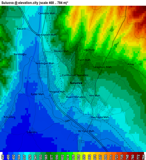
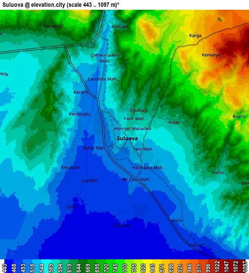
Below is the Elevation map of Suluova, which displays elevation range with different colors. Scale of the first map is from 468 to 784 m (1535 to 2572 ft) with average elevation of 548.5 meters (=1800 ft) [note 1]
These maps also provides idea of topography and contour of this city, they are displayed at different zoom levels. More info about maps, scale and edge coordinates you can find below images.
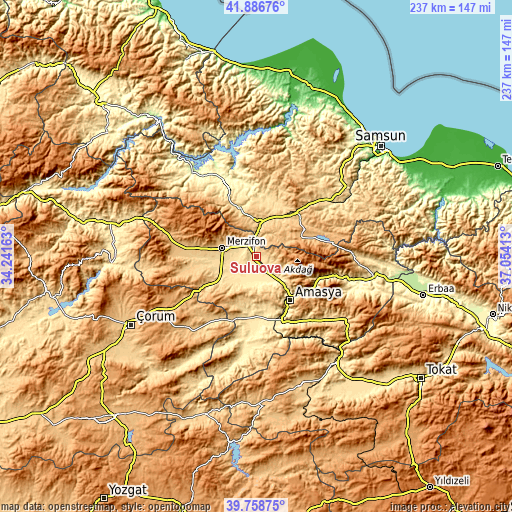
| \ | Map #1 | Map #2 | Topo.Map |
| Scale [m] | 468..784 m | 443..1097 m | × |
| Scale [ft] | 1535..2572 ft | 1453..3599 ft | × |
| Average | 548.5 m = 1800 ft | 604.7 m = 1984 ft | × |
| Width | 7.39 km = 4.6 mi | 14.79 km = 9.2 mi | 236.6 km = 147 mi |
| Height | 7.39 km = 4.6 mi | 14.79 km = 9.2 mi | 236.6 km = 147 mi |
| ↑Max Latitude | 40.864532° | 40.897758° | 41.88676° |
| Latitude at center | 40.83129° | 40.83129° | 40.83129° |
| ↓Min Latitude | 40.798031° | 40.764755° | 39.75875° |
| ← Min Longitude | 35.603935° | 35.559989° | 34.24163° |
| Longitude center | 35.64788° | 35.64788° | 35.64788° |
| →Max Longitude | 35.691825° | 35.735771° | 37.05413° |
Nearby cities:
Cities around Suluova sort by population:
• Amasya elevation 402 m
25.2 km,  141°
141°
• Merzifon 732 m
16.2 km,  286°
286°
• Vezirköprü 335 m
38.3 km,  334°
334°
• Havza 632 m
15.5 km,  4°
4°
• Gümüşhacıköy 822 m
36.7 km,  277°
277°
• Ladik 940 m
22.3 km,  66°
66°
• Şeyhli 947 m
36.4 km, 73°
• Akdağ 441 m
30.6 km,  115°
115°
• Alıcık 703 m
27.6 km,  263°
263°
• Köprübaşı 629 m
26.4 km,  335°
335°
• Doğantepe 524 m
26.2 km,  188°
188°
• Sarıbuğday 547 m
18.3 km,  239°
239°
Multilingual:
 En español:
Suluova elevación 562 m.
 En France:
Suluova élévation 562 m.


Sources and notes:
- [note 1] Map square and city borders are not equal. Map elevation data is calculated only from area inside that square.
- [src 1] Elevation data from geonames database provided with same terms of usage.
- [src 2] The elevation map of Suluova is generated using elevation data from NASA's 3 arcsec (90m) resolution SRTM data.
- [src 3] Base (background) map © OpenStreetMap contributors tiles are generated by Geofabrik and OpenTopoMap.
Copyright & License:
This Suluova Elevation Map is licensed under CC BY-SA. You may reuse any part from this page, if you give a proper credit by linking to this URL:
 More info on terms of use page.