Tepecik elevation
Tepecik (Istanbul), Turkey elevation is 26 meters and Tepecik elevation in feet is 85 ft above sea level [src 1]. Tepecik is a populated place (feature code) with elevation that is 697 meters (2287 ft) smaller than average city elevation in Turkey.
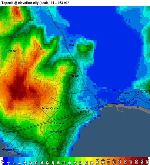
Below is the Elevation map of Tepecik, which displays elevation range with different colors. Scale of the first map is from -11 to 163 m (-36 to 535 ft) with average elevation of 43 meters (=141 ft) [note 1]
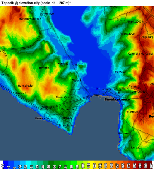
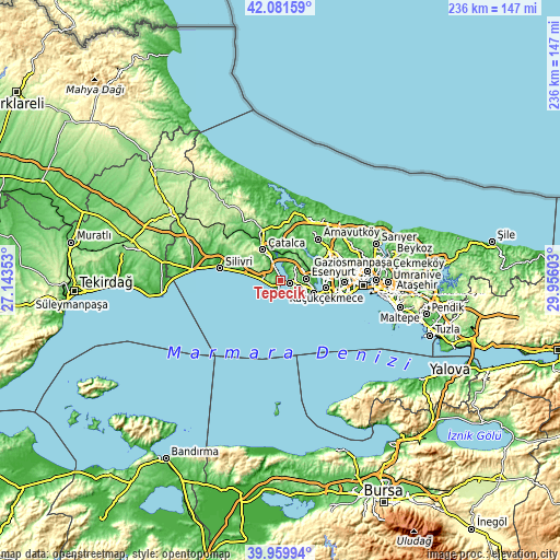
These maps also provides idea of topography and contour of this city, they are displayed at different zoom levels. More info about maps, scale and edge coordinates you can find below images.
| \ | Map #1 | Map #2 | Topo.Map |
| Scale [m] | -11..163 m | -11..207 m | × |
| Scale [ft] | -36..535 ft | -36..679 ft | × |
| Average | 43 m = 141 ft | 73.8 m = 242 ft | × |
| Width | 7.37 km = 4.6 mi | 14.74 km = 9.2 mi | 235.9 km = 146.6 mi |
| Height | 7.37 km = 4.6 mi | 14.74 km = 9.2 mi | 235.9 km = 146.6 mi |
| ↑Max Latitude | 41.062453° | 41.095579° | 42.08159° |
| Latitude at center | 41.02931° | 41.02931° | 41.02931° |
| ↓Min Latitude | 40.99615° | 40.962974° | 39.95994° |
| ← Min Longitude | 28.505835° | 28.461889° | 27.14353° |
| Longitude center | 28.54978° | 28.54978° | 28.54978° |
| →Max Longitude | 28.593725° | 28.637671° | 29.95603° |
Nearby cities:
Cities around Tepecik sort by population:
• Esenyurt elevation 97 m
10.7 km,  91°
91°
• Büyükçekmece 5 m
3.1 km,  107°
107°
• Beylikdüzü 102 m
9.2 km,  124°
124°
• Mimarsinan 4 m
1.6 km,  141°
141°
• Gürpınar 113 m
6.8 km,  127°
127°
• Yakuplu 74 m
11.5 km, 112°
• Çatalca 88 m
14.7 km,  329°
329°
• Kumburgaz 42 m
5.9 km,  261°
261°
• Selimpaşa 17 m
15.6 km,  280°
280°
• Celâliye 57 m
11.3 km, 282°
• Muratbey 76 m
8.9 km, 327°
• Chekmejeh 68 m
2.1 km,  207°
207°
Multilingual:
 En español:
Tepecik elevación 26 m.
 En France:
Tepecik élévation 26 m.


Sources and notes:
- [note 1] Map square and city borders are not equal. Map elevation data is calculated only from area inside that square.
- [src 1] Elevation data from geonames database provided with same terms of usage.
- [src 2] The elevation map of Tepecik is generated using elevation data from NASA's 3 arcsec (90m) resolution SRTM data.
- [src 3] Base (background) map © OpenStreetMap contributors tiles are generated by Geofabrik and OpenTopoMap.
Copyright & License:
This Tepecik Elevation Map is licensed under CC BY-SA. You may reuse any part from this page, if you give a proper credit by linking to this URL:
 More info on terms of use page.