Acarlar elevation
Acarlar (Aydın), Turkey elevation is 30 meters and Acarlar elevation in feet is 98 ft above sea level [src 1]. Acarlar is a populated place (feature code) with elevation that is 693 meters (2274 ft) smaller than average city elevation in Turkey.
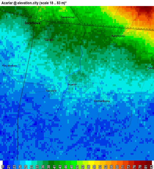
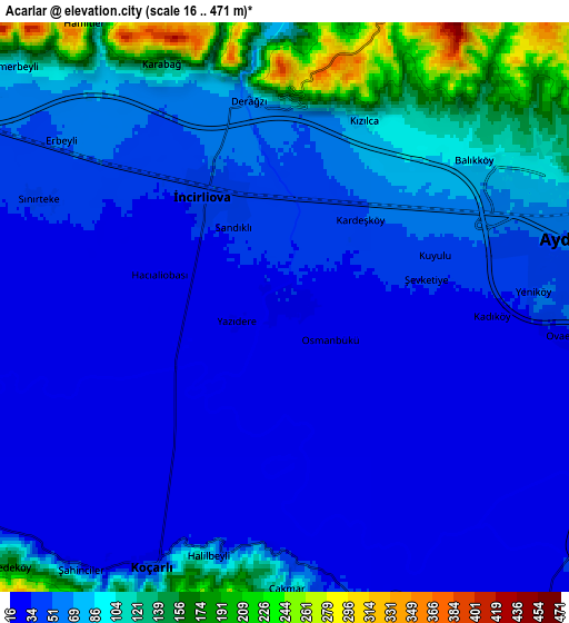
Below is the Elevation map of Acarlar, which displays elevation range with different colors. Scale of the first map is from 18 to 83 m (59 to 272 ft) with average elevation of 31.3 meters (=103 ft) [note 1]
These maps also provides idea of topography and contour of this city, they are displayed at different zoom levels. More info about maps, scale and edge coordinates you can find below images.
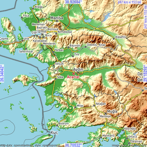
| \ | Map #1 | Map #2 | Topo.Map |
| Scale [m] | 18..83 m | 16..471 m | × |
| Scale [ft] | 59..272 ft | 52..1545 ft | × |
| Average | 31.3 m = 103 ft | 64.1 m = 210 ft | × |
| Width | 7.72 km = 4.8 mi | 15.44 km = 9.6 mi | 247 km = 153.5 mi |
| Height | 7.72 km = 4.8 mi | 15.44 km = 9.6 mi | 247 km = 153.5 mi |
| ↑Max Latitude | 37.859144° | 37.893832° | 38.92684° |
| Latitude at center | 37.82444° | 37.82444° | 37.82444° |
| ↓Min Latitude | 37.78972° | 37.754983° | 36.70532° |
| ← Min Longitude | 27.702725° | 27.658779° | 26.34042° |
| Longitude center | 27.74667° | 27.74667° | 27.74667° |
| →Max Longitude | 27.790615° | 27.834561° | 29.15292° |
Nearby cities:
Cities around Acarlar sort by population:
• Aydın elevation 67 m
8.5 km,  74°
74°
• İncirliova 48 m
3.7 km,  326°
326°
• Germencik 58 m
13.6 km,  292°
292°
• Köşk 75 m
27 km,  83°
83°
• Koçarlı 37 m
7.9 km,  207°
207°
• Tepecik 42 m
11.3 km,  90°
90°
• Dalama 59 m
28.3 km,  97°
97°
• Boğaziçi 81 m
28.6 km,  324°
324°
• Ortaklar 64 m
22.6 km, 288°
• Bağarası 21 m
21.7 km,  233°
233°
• Umurlu 52 m
19.2 km, 81°
• Çakırbeyli 42 m
12 km,  145°
145°
Multilingual:
 En español:
Acarlar elevación 30 m.
 En France:
Acarlar élévation 30 m.


Sources and notes:
- [note 1] Map square and city borders are not equal. Map elevation data is calculated only from area inside that square.
- [src 1] Elevation data from geonames database provided with same terms of usage.
- [src 2] The elevation map of Acarlar is generated using elevation data from NASA's 3 arcsec (90m) resolution SRTM data.
- [src 3] Base (background) map © OpenStreetMap contributors tiles are generated by Geofabrik and OpenTopoMap.
Copyright & License:
This Acarlar Elevation Map is licensed under CC BY-SA. You may reuse any part from this page, if you give a proper credit by linking to this URL:
 More info on terms of use page.