Bitlis elevation
Bitlis, Turkey elevation is 1494 meters and Bitlis elevation in feet is 4902 ft above sea level [src 1]. Bitlis is a seat of a first-order administrative division (feature code) with elevation that is 771 meters (2530 ft) bigger than average city elevation in Turkey.
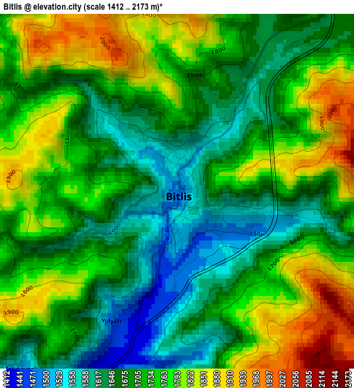
Below is the Elevation map of Bitlis, which displays elevation range with different colors. Scale of the first map is from 1412 to 2173 m (4633 to 7129 ft) with average elevation of 1719.4 meters (=5641 ft) [note 1]
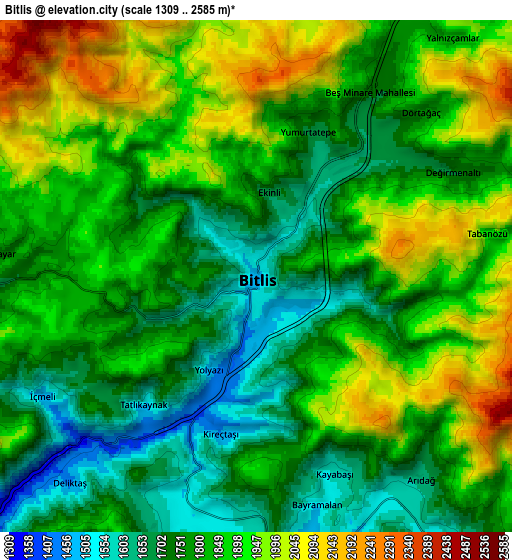
These maps also provides idea of topography and contour of this city, they are displayed at different zoom levels. More info about maps, scale and edge coordinates you can find below images.
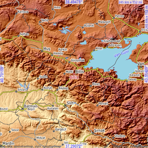
| \ | Map #1 | Map #2 | Topo.Map |
| Scale [m] | 1412..2173 m | 1309..2585 m | × |
| Scale [ft] | 4633..7129 ft | 4295..8481 ft | × |
| Average | 1719.4 m = 5641 ft | 1832.2 m = 6011 ft | × |
| Width | 7.66 km = 4.8 mi | 15.32 km = 9.5 mi | 245.1 km = 152.3 mi |
| Height | 7.66 km = 4.8 mi | 15.32 km = 9.5 mi | 245.1 km = 152.3 mi |
| ↑Max Latitude | 38.435581° | 38.469995° | 39.49478° |
| Latitude at center | 38.40115° | 38.40115° | 38.40115° |
| ↓Min Latitude | 38.366703° | 38.332239° | 37.29072° |
| ← Min Longitude | 42.063895° | 42.019949° | 40.70159° |
| Longitude center | 42.10784° | 42.10784° | 42.10784° |
| →Max Longitude | 42.151785° | 42.195731° | 43.51409° |
Nearby cities:
Cities around Bitlis sort by population:
• Tatvan elevation 1682 m
18.3 km,  56°
56°
• Güroymak 1304 m
21 km,  337°
337°
• Hizan 1491 m
33.4 km,  125°
125°
• Mutki 1567 m
16.4 km,  271°
271°
• Meydan 913 m
29.9 km,  260°
260°
• Narlıdere 897 m
27.1 km,  224°
224°
• Cevizlik 1483 m
27.1 km,  157°
157°
• Kavakbaşı 1360 m
26.7 km,  290°
290°
• Geyikpınar 1710 m
26.7 km,  249°
249°
• Sarıkonak 1215 m
21.8 km, 216°
• Kotum 1739 m
18.9 km,  77°
77°
• Simek 1570 m
10 km,  144°
144°
Multilingual:
 En español:
Bitlis elevación 1494 m.
 En France:
Bitlis élévation 1494 m.


Sources and notes:
- [note 1] Map square and city borders are not equal. Map elevation data is calculated only from area inside that square.
- [src 1] Elevation data from geonames database provided with same terms of usage.
- [src 2] The elevation map of Bitlis is generated using elevation data from NASA's 3 arcsec (90m) resolution SRTM data.
- [src 3] Base (background) map © OpenStreetMap contributors tiles are generated by Geofabrik and OpenTopoMap.
Copyright & License:
This Bitlis Elevation Map is licensed under CC BY-SA. You may reuse any part from this page, if you give a proper credit by linking to this URL:
 More info on terms of use page.