Bucakkışla elevation
Bucakkışla (Karaman), Turkey elevation is 435 meters and Bucakkışla elevation in feet is 1427 ft above sea level [src 1]. Bucakkışla is a seat of a third-order administrative division (feature code) with elevation that is 288 meters (945 ft) smaller than average city elevation in Turkey.
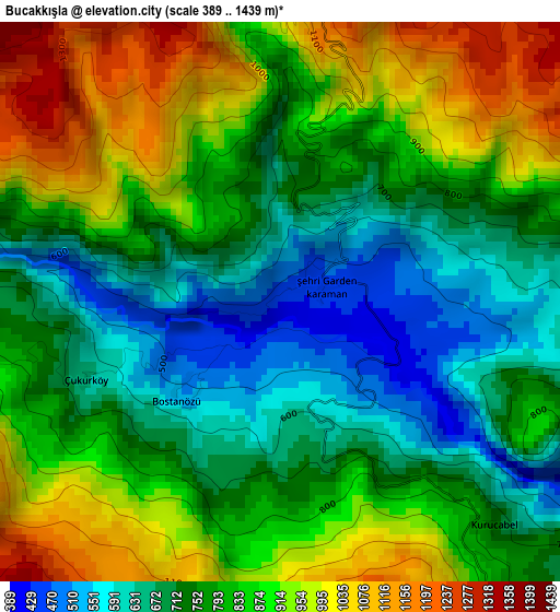
Below is the Elevation map of Bucakkışla, which displays elevation range with different colors. Scale of the first map is from 389 to 1439 m (1276 to 4721 ft) with average elevation of 810.4 meters (=2659 ft) [note 1]
These maps also provides idea of topography and contour of this city, they are displayed at different zoom levels. More info about maps, scale and edge coordinates you can find below images.
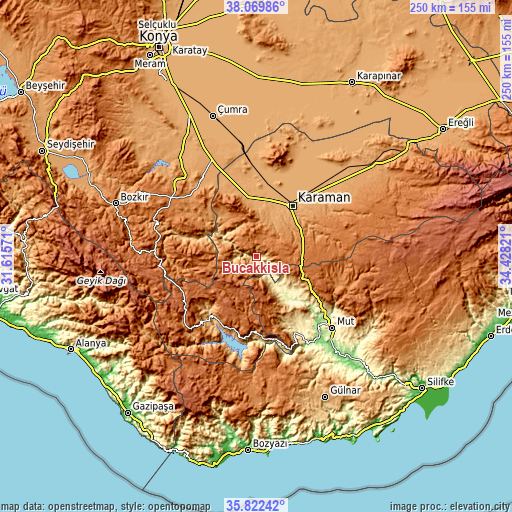
| \ | Map #1 | Topo.Map |
| Scale [m] | 389..1439 m | × |
| Scale [ft] | 1276..4721 ft | × |
| Average | 810.4 m = 2659 ft | × |
| Width | 7.81 km = 4.9 mi | 249.9 km = 155.3 mi |
| Height | 7.81 km = 4.9 mi | 249.9 km = 155.3 mi |
| ↑Max Latitude | 36.989539° | 38.06986° |
| Latitude at center | 36.95443° | 36.95443° |
| ↓Min Latitude | 36.919305° | 35.82242° |
| ← Min Longitude | 32.978015° | 31.61571° |
| Longitude center | 33.02196° | 33.02196° |
| →Max Longitude | 33.065905° | 34.42821° |
Nearby cities:
Cities around Bucakkışla sort by population:
• Karaman elevation 1037 m
30.5 km,  34°
34°
• Hadim 1533 m
50.3 km,  274°
274°
• Ermenek 1312 m
36.8 km,  198°
198°
• Taşkent 1542 m
47.3 km, 265°
• Sarıveliler 1490 m
46.4 km,  231°
231°
• Başyayla 1327 m
37.7 km, 233°
• Kazımkarabekir 1049 m
31.2 km,  349°
349°
• Belören 1375 m
50.6 km,  304°
304°
• Yeşildere 1189 m
49.1 km,  62°
62°
• Kılbasan 1012 m
43.7 km,  19°
19°
• Güneysınır 1122 m
43.6 km,  323°
323°
• Tepebaşı 1059 m
41.7 km,  219°
219°
Multilingual:
 En español:
Bucakkışla elevación 435 m.
 En France:
Bucakkışla élévation 435 m.
 Auf Deutsch:
Bucakkışla höhe über dem Meeresspiegel ist 435 m.

Sources and notes:
- [note 1] Map square and city borders are not equal. Map elevation data is calculated only from area inside that square.
- [src 1] Elevation data from geonames database provided with same terms of usage.
- [src 2] The elevation map of Bucakkışla is generated using elevation data from NASA's 3 arcsec (90m) resolution SRTM data.
- [src 3] Base (background) map © OpenStreetMap contributors tiles are generated by Geofabrik and OpenTopoMap.
Copyright & License:
This Bucakkışla Elevation Map is licensed under CC BY-SA. You may reuse any part from this page, if you give a proper credit by linking to this URL:
 More info on terms of use page.